
Autos Across America; A Bibliography of Transcontinental Automobile Travel: 1903-1940
Los Angeles: Dawson's Book Shop, 1972. Facsimiles. 60pp. 8vo, green cloth. Los Angeles: Dawson's Book Shop, 1972. A near fine copy. One of 315 copies. More
Los Angeles: Dawson's Book Shop, 1972. Facsimiles. 60pp. 8vo, green cloth. Los Angeles: Dawson's Book Shop, 1972. A near fine copy. One of 315 copies. More

Philadelphia: M. Carey & Son. 1823. Map. Original engraving with hand coloring. Sheet measures 17 1/8" x 21 1/2" This educational map of Asia is colored to depict major regions, with delineated areas showing the extents of the empires of Genghis Khan in 1226 and of Tamerlane in 1406. Text surrounding the map provides extensive information on geography, natural history, political divisions, religions and languages, and a summary of the history of the continent. Published by Mathew Carey for Lavoisne's..... More
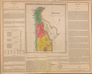
Philadelphia: Carey & Lea, 1822. Map. Engraving with original hand coloring. Map measures 11.75" x 9.75", map plus text measures 16.75" x 21". Fine antique map of Delaware divided into counties, showing towns, major routes and waterways. Includes information pertaining to history, climate and demographics. From "A Complete Historical, Chronological, and Geographical American Atlas..." of 1822. Condition is very good, stain in Governors list. The Philadelphia-based firm of Carey & Lea of Philadelphia was one of the most important publishers..... More
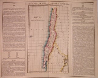
Philadelphia: Carey & Lea, 1823. Map. Engraving with original hand coloring. Image measures 15" x 9", image plus text measure 16.75" x 20.5". Beautiful map of Chili from 1823. Includes information pertaining to history, climate and culture. From "A Complete Historical, Chronological, and Geographical American Atlas..." of 1822. Run by Henry Carey (1793-1879) and Isaac Lea (1792-1886), the company worked with both books and maps, specializing particularly in political commentary. Their "Complete Historical, Chronological, and Geographical American Atlas," first published..... More
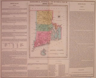
Philadelphia: Carey & Lea, 1822. Map. Engraving with original hand coloring. Image measures 16.5" x 20.25". Page measures 17.5" x 21.75". Great double page map of Rhode Island divided into counties. Shows towns, major routes and waterways. Includes information pertaining to history, climate and culture. Light scattered foxing to margins, and slight toning along centerfold. From "A Complete Historical, Chronological, and Geographical American Atlas..." of 1822. The Philadelphia-based firm of Carey & Lea of Philadelphia was one of the most..... More
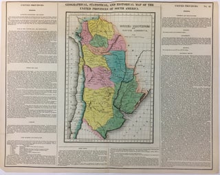
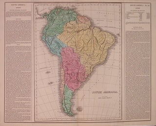
Philadelphia: Carey & Lea, 1822. Map. Engraving with original hand coloring. Image measures 13" x 9", image plus text measures 17" x 21". Includes information pertaining to history, climate and culture. One of the new maps of Argentina after it declared its independence from Spain in 1816. From "A Complete Historical, Chronological, and Geographical American Atlas..." of 1822. Top margin cropped. The Philadelphia-based firm of Carey & Lea of Philadelphia was one of the most important publishers in the early..... More
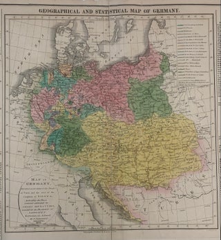
Philadelphia: Carey & Lea, 1823. Map. Engraving with original hand coloring. Map measures 9 3/4" x 11 3/4". Map plus text measures 17 3/4" x 22 3/8". Detailed and informative map of Germany divided according to the Treaty of Paris showing major routes. Austria and Prussia are included. Surrounding text includes geographical information, as well as information on population, commerce, education, religion, and government. Flags note the history ow battles. From Some toning an chips to margins but otherwise in..... More

Philadelphia: Carey & Lea, 1822. Map. Engraving with original hand coloring. Image measures 11 3/4" x 18 1/4", sheet measures 17 1/2" x 21 1/4" Nicely detailed map of the island of Hispaniola (Haiti and the Dominican Republic). Features information pertaining to history, climate and culture, in text below the map, and on accompanying text sheet included. From "A Complete Historical, Chronological, and Geographical American Atlas..." of 1822. In good condition, with one small chip to upper left margin. Otherwise..... More
Philadelphia: Carey & Lea, 1822. Map. Engraving with original hand coloring. Image measures 12.25" x 15 7/8", image plus text measures 16.75 " x 21.75". Nicely detailed map of Jamaica, including information pertaining to history, climate and culture. Maroon rebels are noted in the text. From "A Complete Historical, Chronological, and Geographical American Atlas..." of 1822. The Philadelphia-based firm of Carey & Lea of Philadelphia was one of the most important publishers in the early 19th-century United States. Run by..... More

Philadelphia: Carey & Lea, 1822. Map. Engraving with original hand coloring. Image measures 16 3/4" x 20 1/2" Beautiful double-page map of Maryland divided into counties. Shows towns, major routes, waterways and topography. Major cities are indicated in red. Below the map is text with information pertaining to geography, history, climate, and culture of the state. From "A Complete Historical, Chronological, and Geographical American Atlas..." Includes separate appendix sheet with additional information. In very good condition, with some offsetting. Minor..... More
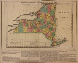
Philadelphia: Carey & Lea, 1823. Map. Engraving with original hand coloring. Map measures 11.75" x 18.25", map plus text measures 16.5" x 19.5". Beautiful double page map of New York state divided into counties. Shows towns, waterways, major routes, and geographical features. A table illustrates the profile levels of the Grand Canal. Includes information pertaining to climate and geography. From "A Complete Historical, Chronological, and Geographical American Atlas..." of 1822. Very small tears to edges. In very good condition... More
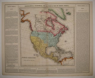
Philadelphia: Carey & Lea, 1823. Map. Engraving with original hand coloring. Image measures 14" x 13.25", image plus text measures 16.5" x 20.5". Beautiful double page map of North America. Towns, states, waterways and topographical details shown in immense detail. Extensive information pertaining to history, climate and culture surrounds map. From "A Complete Historical, Chronological, and Geographical American Atlas...". Minor toning along original centerfold. More
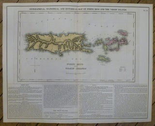
Philadelphia: Carey & Lea, 1822. Map. Engraving with original hand coloring. Image measures 15"x 14.5", image plus text measures 16.5" x 20.5". Beautiful map of Puerto Rico and the Virgin Islands on a large scale. An explanation of colonial activity is provided as well as the publisher's signature text surround pertaining to history, climate and culture. The map was printed in Carey & Lea's "Complete Historical, Chronological, and Geographical American Atlas". Very good condition with no chips or tears or..... More
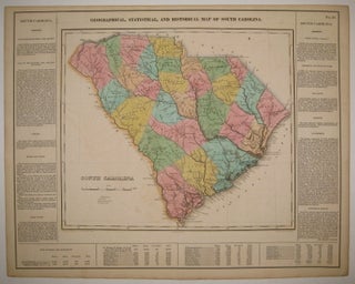
Philadelphia: Carey & Lea, 1822. Map. Engraving with original hand coloring. Image measures 12.75" x 14.75", image plus text measures 16.25" x 20.75". Beautiful double page map of South Carolina divided into counties. Towns, states, waterways and topographical details shown in immense detail. Extensive information pertaining to history, climate and culture surrounds map. From "A Complete Historical, Chronological, and Geographical American Atlas...". Very light offsetting, small tear to right edge. Center fold re-inforced. Small stain to upper right. Otherwise in..... More
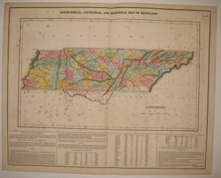
Philadelphia: Carey & Lea, 1822. Map. Engraving with original hand coloring. Image measures 11 7/8" x 10", image plus text measures 16.5" x 20 5/8". Rare double page map of Tennessee divided into counties. Shows towns, major routes, waterways and topography. Extensive information pertaining to history, climate and culture surrounds map. From "A Complete Historical, Chronological, and Geographical American Atlas...". Foxing throughout entire sheet, as is common with this map due to its placement in the atlas. Priced as is..... More

Philadelphia: Carey & Lea, 1822. Map. Engraving with original hand coloring. Image measures 10 3/4" x 10 5/8", image plus text measures 16 3/4" x 20 5/8". Beautiful double page map of Washington D.C. and its environs, including Alexandria. Shows street plan, major roads, waterways, marshlands and topography. Extensive information pertaining to history, climate and culture surrounds map. From "A Complete Historical, Chronological, and Geographical American Atlas..." In very good condition, with minor splitting to ends of centerfold and minimal..... More

Philadelphia: Carey & Lea, 1822. Map. Engraving with original hand coloring. Image measures 12.25" x 15 7/8", image plus text measures 16.75 " x 21.75". Nicely detailed map of the West Indies chain, including information pertaining to history, climate and culture. From "A Complete Historical, Chronological, and Geographical American Atlas..." of 1822. The Philadelphia-based firm of Carey & Lea of Philadelphia was one of the most important publishers in the early 19th-century United States. Run by Henry Carey (1793-1879) and..... More
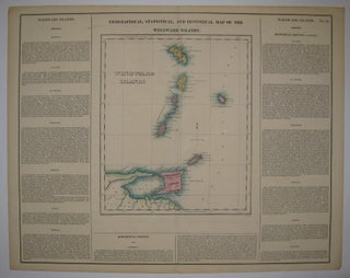
Philadelphia: Carey & Lea, 1822. Map. Engraving with original hand coloring. Image measures 11 5/8" x 10", image plus text measures 16 5/8" x 20.75". Nice map of the Windward Islands, including information pertaining to history, climate and culture of Martinique, St. Lucia, St. Vincent, Barbados, Grenada, Trinidad and Tobago. From "A Complete Historical, Chronological, and Geographical American Atlas..." of 1822. Minor aging along edges, small chip to lower right corner. More
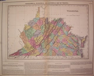
Philadelphia: Carey & Lea, 1823. Map. Engraving with original hand coloring. Map measures 12" x 18". Map plus text measures 16.5" x 20.5". Early map of Virginia divided into counties. Shows towns, waterways, major routes and topographical features. Surrounding text includes geographical information and a separate appendix has information on demographics, chief towns, internal improvements, canals, literary fund, education, agriculture and commerce, government and religion. Appendix included. From "A Complete Historical, Chronological, and Geographical American Atlas..." of 1822. Minor toning..... More
Philadelphia: Carey & Lea, 1822. Map. Engraving with original hand coloring. Image measures 16.5" x 12", image plus text measures 16.5" x 20.25". Includes information pertaining to history, climate and culture. From "A Complete Historical, Chronological, and Geographical American Atlas..." of 1822. Minor foxing along upper margins. More
London: Wertheim, 1858. Translated from the Hebrew. Illustrated with 80 woodcuts and a folding map, some scattered foxing, including the title page and map. 486 pages. Tall 8vo, 3/4 brown morocco, marbled boards. London: Wertheim, Macintosh, and Hunt, 1863. Very good. More
Hampshire, England: The Delphic Press, 1949. Slim 8vo, wrappers housed in black cloth binders. Hampshire, England: The Delphic Press, (1949, 1950, 1951, 1952, 1955). Very good. More
New York: Knopf, 1988. Illustrated. 331pp, 8vo, cloth-backed boards, dust wrapper. N.Y.: Alfred A Knopf, 1988. A near fine copy in a very good dust wrapper. More
New York: Dutton, 1977. Illustrated. 248pp. 8vo, cloth-backed boards. New York: E. P. Dutton, 1977. Near-fine copy in a very good dust wrapper. More
1983. 284pp. 8vo, bds., d.w. N.Y.: St. Martin's Press, 1983. vg. More
An oasis in the restless city. One of my best discoveries in NYC.
Greetings from Ireland... I was in your store on a snowy Thursday last week. I picked up 3 books and you went to a lot of trouble giving me information on having them shipped to Ireland. I purchased the books and they arrived this morning. They were superbly packed... paper, bag and box. They are in perfect condition Despite being in NYC most years its the first time I've been in your wonderful bookstore. It wont be my last visit! Keep up the good work.