
The Soviet Viewpoint
New York: Dodd, Mead & Co., 1983. 219 pages. 8vo, cloth-backed boards, d.w. (chipped at spine top). New York: Dodd, Mead & Co. (1983). A fine copy in a near fine dust wrapper. More
New York: Dodd, Mead & Co., 1983. 219 pages. 8vo, cloth-backed boards, d.w. (chipped at spine top). New York: Dodd, Mead & Co. (1983). A fine copy in a near fine dust wrapper. More
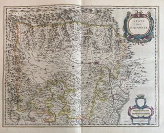
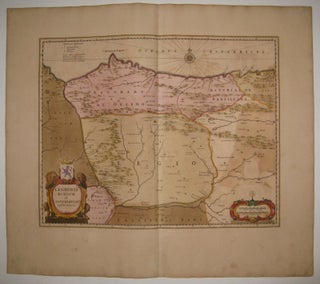
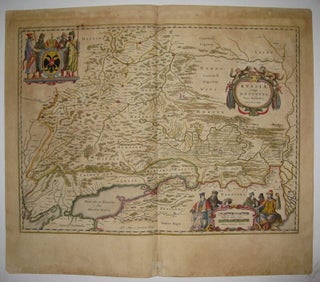
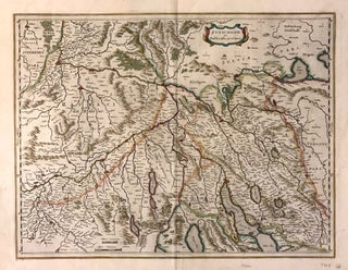
Amsterdam: Johannes Blaeu. Map. Copper plate engraving with original hand coloring. Image measures 15" x 19.5". This lovely map of the Piedmont region of Italy by Johannes Blaeu dates to circa 1667. Featuring the region of Piedmont in northwestern Italy, the map also depicts parts of France in incredible detail. Notes several topographical and political information with mountains and forests beautifully rendered in profile. The region of Piedmont is known for a variety of Italian wines, especially the velvety Barolo..... More
Amsterdam. Map. Engraving with original hand outline. Image measures 15" x 19.75". Beautiful regional map of northern France, circa 1640. Includes Paris in the south east and the winding Seine River. Great cartouche vignette of the goddess of agriculture, Ceres, and a figure in a cart drawn by two winged dragons. Willem Blaeu (1571-1638) was a prolific Dutch mapmaker who started one of the most famous map publishing firms of the 17th century. It was at this time that the..... More

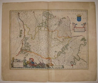
Amsterdam: Willem Blaeu. Map. Engraving with original hand color. Image measures 15 x 19 1/2" This wonderful map from circa 1640 covers the Pays de la Loire region of France, with the city of Le Mans prominently featured in the center right. The map beautifully renders mountains and cities in profile, and notes towns, villages, rivers and other topography. The French region comprising the Loire Valley is famous for its vineyards. The city of Le Mans is the historic heart..... More
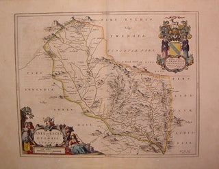
Amsterdam: 1634. Map. Engraving with original hand coloring. Image measures 16.5" x 20.5", page measures 21.5 x 25.75". Rare example from Spanish edition of "Theatrum Obis Terrarum" published in 1634. Shows section of Southern Uplands. Willem Blaeu (1571-1638) was a prolific Dutch mapmaker who started one of the most famous map publishing firms of the 17th century. It was at this time that the Dutch controlled the map trade, and their ornate and beautiful maps had immense popularity. Blaeu was..... More
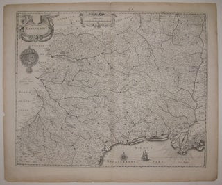
Amsterdam. Map. Uncolored engraving. Image measures 17 3/8" x 21.5". This beautiful map of the province of Languedoc, the French winemaking region in southern France by Willem Bleau dates to circa 1645. Covers from Auvergne to the Mediterranean and includes extraordinary detail throughout, noting several towns, rivers and topographical features. The region of Languedoc is one of the largest wine producing region in France with some of the oldest vineyards. It is also famous for the production of cheeses including..... More
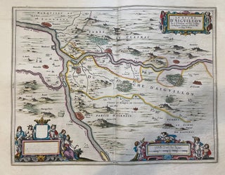
Amsterdam: Willem Blaeu. Map. Engraving with original hand color. Image measures 15 x 19.5". This fine antique map by Willem Blaeu depicts the Duchy of Aiguillon, now a commune of the Lot-et-Garonne department of southwest France. The map identifies important towns, fortifications, rivers, vineyards and villages throughout with beautifully rendered mountains and forests.The Garonne river is prominently featured and it's tributary the Lot river. The Lot-et-Garonne region of France is known for its Buzet wines. The map includes three cartouches..... More
Amsterdam: Willem Blaeu. Map. Engraving with original hand coloring. Image measures 14.75" x 18.75". Beautiful map of northwest Spain in original color with gold highlights, circa 1650. Decorative elements include a compass rose and two ornate cartouches-one with lions holding a coat of arms, and the other with an armillary sphere. Minor overall aging and offsetting, full original margins. Willem Blaeu (1571-1638) was a prolific Dutch mapmaker who started one of the most famous map publishing firms of the 17th..... More

Amsterdam: Willem Blaeu, 1643. Map. Copper plate engraving with original hand coloring. Image measures 14 3/4" x 18 7/8" This beautiful 1643 map by Willem Blaeu depicts the Rio de la Plata region in South America, showing Paraguay, Uruguay, parts of Argentina and Brazil. The Andes mountain range in present-day Peru and Chile is elegantly rendered in pictorial detail. Indigenous groups are extensively noted along the Rio de la Plata. Rivers, towns, cities, lakes, and a host of additional topographic..... More
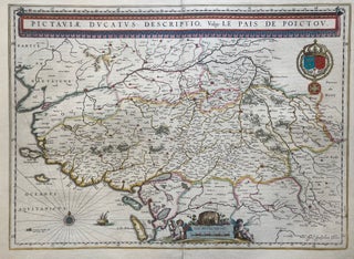
Amsterdam: Willem Blaeu. Map. Engraving with original hand color. Image measures 15 x 19.5". Lovely map of the Poitou region of southwest France with delightful banner title. The map identifies important towns, fortifications, rivers, vineyards and villages throughout with beautifully rendered mountains and forests. The white wines of Haut-Poitou are noted for their powerful aroma. Sauvignon blanc and Cabernet franc is produced in the region. A wine barrel and grapes rest on top of the scale cartouche. In good condition..... More
Amsterdam: 1630. Map. Engraving with hand outline. Image measures 16.25" x 21.25". Beautiful map of northwestern Russia from the White Sea to the Ob River. Great detail along the Northern Dvina River. Dutch text on back. One of the most famous mapmakers of his time, Blaeu (1571-1638) and his family worked out of Amsterdam. Minor aging and tears along edges. Small chips to bottom edge. Full original margins. More
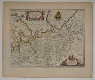
Amsterdam: 1634. Map. Engraving with hand outline. Image measures 15.25" x 20.75". Fine antique map of Russia, centered on Moscow. Beautifully colored and detailed cartouches and coat of arms. Latin text on verso. Willem Blaeu (1571-1638) was a prolific Dutch mapmaker who started one of the most famous map publishing firms of the 17th century. It was at this time that the Dutch controlled the map trade, and their ornate and beautiful maps had immense popularity. Blaeu was instrumental in..... More
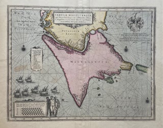
Amsterdam: Willem Blaeu, 1638. Map. Engraving with original hand coloring. Image measures 16.25" x 21" This intriguing 1638 map depicts Tierra del Fuego, an archipelago off the southernmost tip of South America that is separated from Patagonia by the Straits of Magellan. Discovered in 1520 by its namesake, this narrow strip of water attracted significant European attention as the fastest connection between the Atlantic and the Pacific. Enticing, but not easy: as the illustration of seven ships in the lower..... More
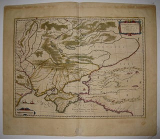
Amsterdam. Map. Engraving with hand outline. Image measures 15" x 19 11/16". Beautiful map of Ukraine showing the area north of the Black Sea including Moscow, circa 1630. Latin text on verso. Willem Blaeu (1571-1638) was a prolific Dutch mapmaker who started one of the most famous map publishing firms of the 17th century. It was at this time that the Dutch controlled the map trade, and their ornate and beautiful maps had immense popularity. Blaeu was instrumental in driving..... More
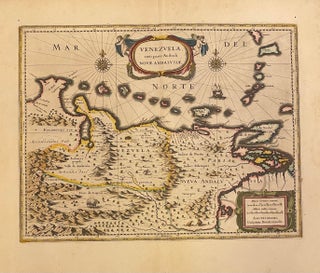
Amsterdam: Willem Blaeu, 1630. Map. Copper plate engraving with original hand coloring. Image measures 14 3/4" x 19" This beautiful 1630 map by Willem Blaeu depicts Venezuela, and the Spanish colony of New Andalusia. The region's topography, flora, and fauna are elegantly rendered in pictorial detail. Rivers, towns, cities, lakes, and other topographic features are labeled. A decorative title cartouche is held up by two cherubs, with two compass roses on either side. Blaeu's inscription is in the lower right..... More
Amsterdam. Map. Engraving with hand coloring. Image measures 15" x 19.75". This striking circa 1640 map by Willem Blaeu depicts the regions of Zurich and vicinity, Switzerland. The map covers northern Switzerland and extends from Mullhouse to the Obersee. The important towns of Basel, Lucerne, Zurich, Argow, and several others are noted in profile. The map also labels lakes, rivers and other topographic features with beautifully rendered mountains and forests. Latin text on verso provides interesting history and description of..... More
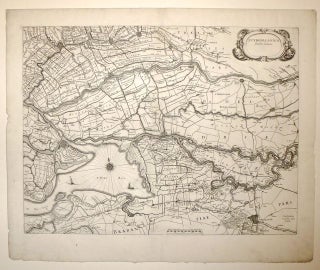
Map. Engraving. Image measures 15 x 20". Sheet measures 18.25 x 22". This region in South Holland and Brabant is surrounded by rivers and marshes. Blaeu renders the map beautifully and depicts dykes, canals, polders and peat moss farms most prominently rather than emphasizing towns and roads. This region is now an extensive tidal freshwater wetlands preserve and a national park. The map is in excellent condition with full margins, no text on verso, possible separate issue map for use..... More
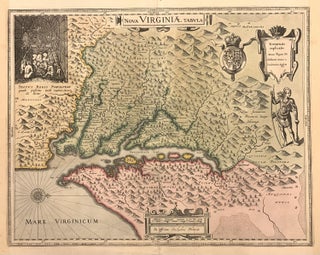
Amsterdam: Willem Blaeu, 1630. Map. Engraving with original hand coloring. Image measures 14.75" x 18.75". This rare and early 1630 map of the Chesapeake Bay and the Virginia Colony, originally derived from John Smith's 1612 map, was created by Willem Blaeu in 1630. Oriented with north to the right, it covers the Chesapeake Bay from Cape Henry to the Susquehanna River, depicting settlements, geographical features, and Smith's exploration limits. Settlements are marked with a house and the parameters of Smith's..... More
New York: Knopf, 1997. 444pp. 8vo, cloth-backed boards, dust wrapper. New York: Alfred A. Knopf, 1997. Near fine. More

1922. Portrait photograph of Dutch conductor Willem Mengelberg signed and dated May, 1922. Inscribed to Steinway and Sons "With heartfelt thanks". Please inquire for more information. Joseph Wilhelm Mengelberg was a Dutch conductor, famous for his performances of Beethoven, Brahms, Mahler and Strauss with the Concertgebouw Orchestra in Amsterdam. He is widely regarded as one of the greatest symphonic conductors of the 20th century. More
Los Angeles: Borden, 1953. 24 color plates, 96 black & white illustrations, 9 figure illustrations. 204 pages. Tall 8vo, burgundy cloth, d.w. Los Angeles: Borden Publishing, 1953. A fine copy in a very good dust wrapper. Presentation by the author. More
Los Angeles: Borden, 1953. 24 color plates, 96 black & white illustrations, 9 figure illustrations. 204 pages. Tall 8vo, burgundy cloth, lightly edgeworn d.w. Los Angeles: Borden Publishing, 1953. Ownership signature, still a very good(+) copy in a very good dust wrapper. More
New York: Simon & Schuster, 1933. 3 color illustrations and many in black & white. 8vo, green cloth with colored pictorial label, dust wrapper. New York: Simon & Schuster, 1933. First Edition. The binding is rubbed and soiled & the spine faded; the chipped dust wrapper is heavily reinforced on the verso, but the book is special because of the original watercolor & ink drawing of an elephant family, along with a 1933 presentation covering an entire blank fly-leaf... More
Many thanks for your prompt reply informing me that the book is now set aside for the library. It's great that you are willing and able to send an invoice with the book -- it makes life a little easier when you work for a very large institution! Thanks again.
Dear Argosy, Thank you for arranging a cheaper price on delivery to Hong Kong. I can say on my honnour, that if Spielberg, Jackson or Lucas, signed a contract with me for the most incredible Spiritual Byzantine blockbuster Saga of all times in Motion pictures, I will come to your shop in person when we will release the 1st movie of the 1st trilogy among the 22 and I will give you back this money :-) Truly, in God! May the Mother of God and all Saints of Mount Athos bless you for ever and ever. - J
