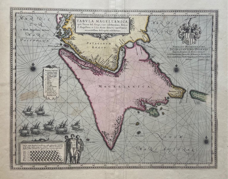
Tabula Magellanica qua Tierrae del Fuego, cum celeberrimis fretis
Amsterdam: Willem Blaeu, 1638.
Map. Engraving with original hand coloring. Image measures 16.25" x 21"
This intriguing 1638 map depicts Tierra del Fuego, an archipelago off the southernmost tip of South America that is separated from Patagonia by the Straits of Magellan. Discovered in 1520 by its namesake, this narrow strip of water attracted significant European attention as the fastest connection between the Atlantic and the Pacific. Enticing, but not easy: as the illustration of seven ships in the lower left corner of the map suggests, the straits were subject to unpredictable wind and currents. Largely unexplored, the archipelago's main island (labeled as Magellanica) is mostly blank, save for some descriptive topographical drawings along the coastlines. Water features are intricately labeled, perhaps because many sailors found themselves shipwrecked as they traveled the straits. At the right of the map is the Le Maire Strait, which at the time of its discovery was thought to separate Tierra del Fuego from the Great Southern Continent of Antarctica. In addition to decorative cartouches, the map also features an elaborate coat of arms, below which Blaeu has dedicated the map to the Dutch statesman Sir Constantijn Huygens (1596-1687). At left beneath the ships is a diagram of the region's latitude, to the right of which stand four indigenous figures: perhaps the giants that many Europeans believed to inhabit the Patagonia region up through the 18th century.
The map appeared in the French edition of Blaeu's "Le Theatre du Monde". The map is in good condition with minimal wear along the original centerfold and minor foxing. Expert verso repair over worm holes near left and right margins. Original plate mark visible.
Willem Blaeu (1571-1638) was a prolific Dutch mapmaker who started one of the most famous map publishing firms of the 17th century. It was at this time that the Dutch controlled the map trade, and their ornate and beautiful maps had immense popularity. Blaeu was instrumental in driving this dominance in his lifetime, and this legacy was continued by his sons. This map of Tierra del Fuego is one of the most handsome of the region.
Binding: Unbound
Language: Latin
Price: $750.00
Item #299794