
Antique Maps of the 19th Century World
New York: Portland House, 1989. Large folio. Dust wrapper taped at corners. 179 pages, 84 full color maps. In very good condition. New York: Portland House, 1989. More
New York: Portland House, 1989. Large folio. Dust wrapper taped at corners. 179 pages, 84 full color maps. In very good condition. New York: Portland House, 1989. More

London: Tallis, John, 1851. Map. Steel engraving with outline hand color. Sheet measures 10 5/8" x 14 1/4". This beautiful 1851 map by John Tallis depicts the Arabian Peninsula and extends from the Syrian Desert south to the Bad-el-Mandeb Strait and the Gulf of Aden. Several important towns, cities are noted and topography is detailed throughout. The map, typical of all Tallis' maps shows decorative vignettes that amplify the cultural milieu perceived at the time. These include a view of..... More
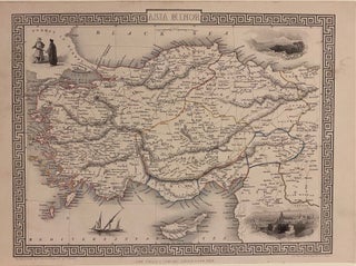
London: Tallis, John, 1857. Map. Steel engraving with modern coloring. Image measures 10 1/4" x 12 3/4" This map of Turkey and the Middle East covers the regions between the Black Sea and Mediterranean, extending from Constantinople to Raqqa. The region is abundantly labeled with the names of cities, rivers, roads, and topographical features. The decorative vignettes, illustrated by H. Warren and engraved by J. H. Kernot, depict Olympus and Rhodes. An illustration of figures in traditional dress, and a...... More
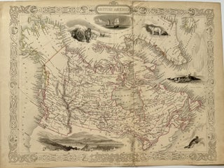
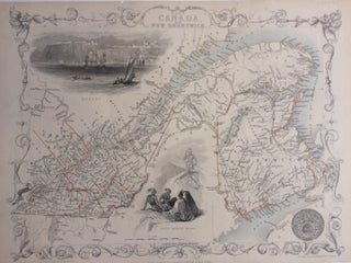
London: Tallis, John, 1849. Map. Steel engraving with original hand coloring. Image measures 10.5" x 12.75". Detailed map of Canada, showing Forts and Stations (noted as houses) of 'The Hudson's Bay Company'. It was the oldest corporation in North America, founded in 1670. Regional divisions are indicated with hand colored outline. This is the rare first state of the map supporting the British centric claim of the disputed territory in Oregon, showing the land south to the Columbia River called..... More
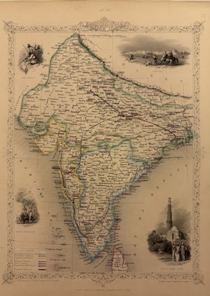
London: John Tallis & Company, 1860. Map. Steel engraving with outline hand color. Page measures 13 7/8" x 10 5/8" Lovely map of India in the mid-19th century. Features four vignettes showing the Beloochee's; Lahore; Cootub Minar, Delhi (a world heritage site); and Indian Procession in the lower left with elephants. Hand colored to show proposed railroads connecting Bombay, Calcutta, and Delhi. Regions are also colored, representing the Presidencies of Madras, Calcutta, and Bombay; as well as territories controlled by..... More
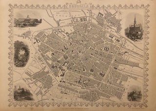
London: John Tallis & Company, 1851. Map. Original engraving. Page measures 13 7/8" x 10 5/8" Lovely map of Brussels, Belgium in the mid-19th century surrounded by a decorative border. Five vignettes adorn the map, featuring illustrations of the Palace Royal, Hotel de Ville, Church of St. Gudule, an Avenue in the Park, and Brussels near the Porte D'Anderlecht. Map drawn and engraved by J. Rapkin; illustrations drawn and engraved by J. Watkins. In very good condition. John Tallis Jr...... More

London: Tallis, John, 1851. Map. Steel engraving with color hand outline. Image measures 14.5" x 10.25". Illustrations drawn and engraved by Henry Winkles. Highly detailed map of Ceylon, the island today known Sri Lanka. Vignettes in black and white include Temple of Buddha Kalany, Ruins of a Dagoba at Toopharamaya, Lake Kandy, Adams Peak from the Lake of Colombo, and a view of the city of Colombo. Hand coloring outlines provinces and districts. Beautiful decorative border encapsalates this map. John..... More
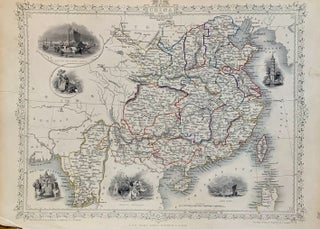
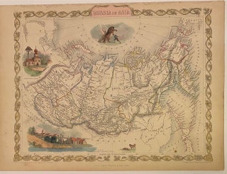
London: J. Rapkin, 1851. Map. Steel engraving with original hand colored outlining. Image measures 10 1/2" x 14 1/2". This map of China and Burma offers both geographical and cultural overviews. Map also extends to parts of Tibet, Bhutan, Assam, and Bengal in the west, Mongolia in the north, Korea and Liaoning in the northeast, Siam and Lao in the south. China and Burma are abundantly labeled with the names of cities, counties, rivers. The decorative vignettes around the map..... More
London: J. Rapkin. Map. Steel engraving with original hand coloring. Image measures 10.5" x 12.75". In good condition, with no center fold or crease as is common with this map. This map of Eastern Canada and New Brunswick shows the span of the St. Lawrence river from Gaspe to Montreal. Decorative vignettes show a view of Quebec from the river, and a grouping of North American Indians. The map is from R. Montgomery's "Illustrated Atlas and Modern History of the..... More

London: Tallis, J & F, 1851. Set of two maps. Steel engraving with hand coloring. Image measures 9.75" x 13". Beautiful world map in two sheets of the western and eastern hemispheres with a highly decorative border featuring twelve vignettes with illustrations of native fauna and peoples. The western hemisphere map shows North and South America, as well as the Atlantic and Pacific Oceans - including the Azores and Cape Verde islands, and the South Seas. The eastern hemisphere map..... More
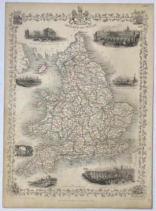
London: Tallis, John, 1851. Map. Steel engraving with hand-coloring. Image measures 14" x 10". This lovely map of England and Wales includes districts, railroads, and canals. County borders are hand-colored. Six vignettes of famous locales are included: the Race Ground in Doncaster, London, Oxford, Portsmouth Harbour, Sunderland Bridge, and Newcastle-Upon-Tyne. A seventh vignette depicts men on jumping horses. This map is from Tallis's 1851 "Illustrated Atlas", and was drawn and engraved by J. Rapkin. Illustrations by N. Whittock and engraved..... More

London: John Tallis & Company, 1860. Map. Steel engraving with outline hand color. Page measures 13 7/8" x 10 5/8" Lovely map of Holland in the mid-19th century surrounded by a decorative border. Three vignettes adorn the map, featuring illustrations titled "On the Dort", "Dutch Peasants", and "Rotterdam". Hand colored to show regional divisions, with cities, towns, rivers, canals, and railroads labeled. Map drawn and engraved by J. Rapkin, illustrations by H. Warren and engraved by J.B. Allen. In very..... More
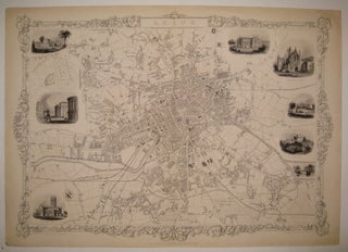
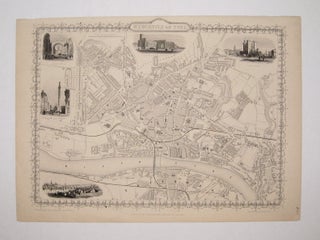
London: Tallis, John, 1851. Map. Steel engraving. Image measures 14.25" x 19.75". Classic town plan of Leeds in North East England on the Aire River in West Yorkshire. Includes districts, Railroads, cricket fields, moors and canals. The plan is surrounded eight lovely vignettes of notable buildings. No stains or chips or cropping usually seen in the Tallis series, in excellent condition. John Tallis Jr. (1817-1876) was a London born bookseller who continued the prolific map publishing company started by his..... More
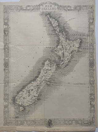
London: Tallis, John, 1851. Map. Steel engraving. 14 x 10 1/4 inches. Beautiful map of New Zealand without the typical vignettes. Tallis substitutes his usual decorative border for a traditional Maori pattern. In very good condition, with minor chips to margins. Folded as issued with several creases. John Tallis Jr. (1817-1876) was a London born bookseller who continued the prolific map publishing company started by his father. After a partnership with his brother, Tallis Jr. expanded the business to New..... More
London: Tallis, John, 1851. Map. Steel engraving. Image measures 9 3/4" x 13 1/4". Lovely town plan of Newcastle on Tyne in Northeast England, with the River Tyne running along the bottom edge. Includes districts, Railroads, and canals and five vignettes of notable buildings. No stains or chips usually seen in the Tallis series. The top margin, however, is closely cropped. John Tallis Jr. (1817-1876) was a London born bookseller who continued the prolific map publishing company started by his..... More
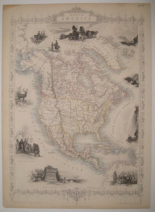
London: Tallis, John, 1851. Map. Steel engraving with original hand outline. Image measures 14" x 9.5". Beautifully detailed and decorative map of North America. States and territories are demarcated in the United States, Canada and Mexico. Vignettes include "Esquimaux Dog-Sledge", "Mount Hekla", "Beavers", "Falls of Niagara", "Convoy of Diamonds", "Ancient Monument, Mexico", "North American Indians", "Wapiti Deer" and "Cossacks". Minor toning to edges. John Tallis Jr. (1817-1876) was a London born bookseller who continued the prolific map publishing company started..... More
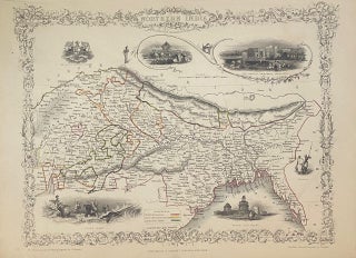
London: Tallis, John, 1851. Map. Steel engraving with original hand outline. Image measures 9 3/4" x 13" Beautiful map of Northern India from the Gulf of Cambay and Bay of Bengal to the Great Indian Desert and Nepal. Vignettes include the seal of the East India Company, "Car of Juggernaut", "The British Presidency, Hyderabad", a scene of a tiger hunt, ruins in Old Delhi and two "Hindoos". A color coded key shows British possessions, states under British protection and independent..... More
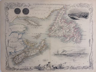
London: J. Rapkin. Map. Steel engraving with original hand coloring. Image measures 10.5" x 12.75". This map of Nova Scotia and Newfoundland offers both geographical and cultural overviews of this eastern region of Canada. The two islands, as well as Prince Edward Island, are shown as they are situated off the coasts of New Brunswick and Labrador. Each is abundantly labeled with the names of cities, counties, rivers, and most importantly, bays and harbors, as these sites were the keys..... More
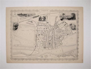
London: Tallis, John, 1851. Map. Steel engraving. Image measures 14.25" x 19.75". Lovely town plan of Perth, Scotland with the River Tay running along the bottom edge. Includes districts, Railroads, and canals and five vignettes of notable buildings. No stains, chips or cropping usually seen in the Tallis series. John Tallis Jr. (1817-1876) was a London born bookseller who continued the prolific map publishing company started by his father. After a partnership with his brother, Tallis Jr. expanded the business..... More
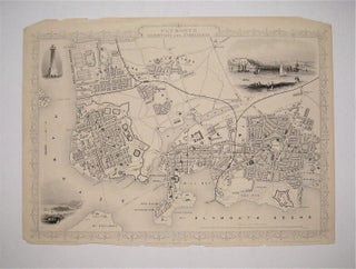
London: Tallis, John, 1851. Map. Steel engraving. Image measures 9 3/4" x 13 1/4". Lovely town plans of Plymouth, Devonport and Stonehouse in Deovon, England, bordered to the south by the Plymouth Sound and the Hamoaze stretch of the River Tamar. Includes districts, Railroads, and canals and three vignettes of notable buildings. The map is in good condition. Corners are worn and there are minor chips and small tears to the other edges, but they do not affect the image..... More
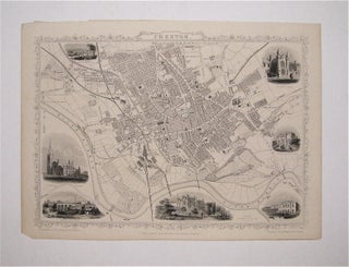
London: Tallis, John, 1851. Map. Steel engraving. Image measures 9 3/4" x 13 1/4". Lovely town plan of Preston in Lancashire, England, bordered to the south by the River Ribble. Includes districts, Railroads, and canals and seven vignettes of notable buildings. No stains or cropping usually seen in the Tallis series. Minor chips to top edge and bottom left corner not affecting the image. John Tallis Jr. (1817-1876) was a London born bookseller who continued the prolific map publishing company..... More
London: Tallis, John, 1851. Map. Steel engraving with hand coloring. Image measures 10" x 12.5". Detailed map of the eastern portion of Russia, from the Ural Mountains to the Bering Strait. Vignettes include "Skorskarskoi Pagost", "Kamtchatkan dogs", the town of "Troitsk" and a bear attack. Foxing in Japan Sea and stains to margins but otherwise in good condition. Map drawn and engraved by J. Rapkin, illustrations by A. Fussell and engraved by J. B. Allen. John Tallis Jr. (1817-1876) was..... More
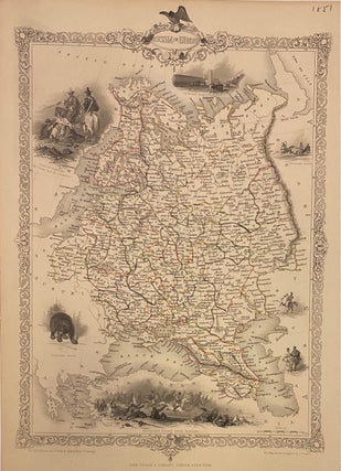
London: Tallis, John, 1851. Map. Steel engraving with original hand outline. Image measures 13.75" x 9.5". Detailed map of the western portion of Russia, from the Baltic Sea to Ural Mountains. Vignettes include "Napoleon's Flight from Moscow", a "Traveling Sledge", "Polish Captives on their way to Siberia" and a "Russian Bear". Map drawn and engraved by J. Rapkin, illustrations by A. H. Wray and engraved by T. Fleming. John Tallis Jr. (1817-1876) was a London born bookseller who continued the..... More
London: Tallis, John, 1851. Map. Steel engraving. Image measures 9 3/4" x 13 1/4". Lovely town plan of Sheffield in Yorkshire, England. Includes districts, Railroads, and canals and two vignettes of notable buildings. No stains, chips or cropping usually seen in the Tallis series. John Tallis Jr. (1817-1876) was a London born bookseller who continued the prolific map publishing company started by his father. After a partnership with his brother, Tallis Jr. expanded the business to New York in 1849..... More
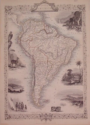
London: Tallis, John, 1851. Map. Steel engraving with original hand outline. Image measures 14" x 9.5". Includes black and white vignettes, "Gold Washing in Brazil", "Brazilian Bridge of Ropes", "Rio Janeiro", "Natives of Chili", "Descent of the Cordilleras", "Valparaiso", "Condor and Llamas of Peru". Some discoloration along edges. More
Dear Argosy, I just finished watching TV. Now I know there is the old books store called Argosy in Manhattan, New York. I've been looking for first edition of Little Women written by Louisa May Alcott. Do you have it? If you do please let me know.
Hello You are not going to believe this but the book was delivered YESTERDAY - we were out so they came again today. That's what I call service!!!!!!!! Thanks for the careful packing - the book is lovely. Thanks again