
Songs of Manhattan
Boston: Cornhill, 1918. Small slim 8vo. (12), 70 pages. Black cloth-backed pictorial tan boards; upper front joint neatly repaired. Boston: Cornhill Co., (1918). First Edition. Very good(+). More
Boston: Cornhill, 1918. Small slim 8vo. (12), 70 pages. Black cloth-backed pictorial tan boards; upper front joint neatly repaired. Boston: Cornhill Co., (1918). First Edition. Very good(+). More

New York: Beers, Comstock & Cline, 1867. Map. Lithograph with original hand coloring. Image measures 15 3/4" x 13" Beautifully hand colored map of New York City, showing Manhattan up to 155th St., Brooklyn to Prospect Park, as well as Queens and parts of the Bronx and New Jersey. Published in 1867, this map is highly detailed, hand-colored by ward and labeled to show street names, neighborhoods, railroads, parks, ferry lines, and major landmarks. Parks are colored in green, with..... More
Philadelphia: G.W. Bromley, 1925. Map. Original Lithograph. 11.5 x 16.5 inches This ward map of Manhattan shows on the recto the area between East Broadway and the East River, from Manhattan Bridge and Pike Slip to Montgomery St. On the verso, it depicts from the East River at Corlears Hook Park to Grand St., East Broadway, and Montgomery St. Ward maps were used by fire insurance companies to determine the potential hazards of particular buildings. Color-coding indicates building materials: pink..... More
![Item #332592 Plate 106 and Plate 105, Part of Section 5 [Upper East Side]. George W. BROMLEY,...](https://argosybooks.cdn.bibliopolis.com/pictures/332592.jpeg?width=320&height=427&fit=bounds&auto=webp&v=1765489669)
Philadelphia: G.W. Bromley, 1925. Map. Original Lithograph. Sheet measures 11 1/8" x 16" This ward map of Manhattan shows the area from E 71st St. to E 65th St. on the recto, from Central Park to Third Ave. Some notable buildings include Hunter College, St Vincent Ferrer, the Park Avenue Armory, and the Frick Collection. On the verso, it depicts E 59th St. to E 65th St, from Third Ave to Avenue A (York Ave.), showing the entrance to the..... More
Philadelphia: G.W. Bromley, 1925. Map. Original Lithograph. Sheet measures 11 3/8" x 16" This ward map of Manhattan shows the area from E 71st St. to E 65th St. on the recto, from Third Ave to Avenue A (York Ave). Some notable buildings include Central Opera House, Julia Richman School, and St. Catherine's Church. On the verso, it depicts E 59th St. to E 67th St, from Avenue A to the East River, showing the Queensboro Bridge and Rockefeller Institute..... More
![Item #332593 Plate 138 and Plate 139, Part of Section 7 [Morningside Heights]. George W. BROMLEY,...](https://argosybooks.cdn.bibliopolis.com/pictures/332593.jpeg?width=320&height=427&fit=bounds&auto=webp&v=1778524975)
Philadelphia: G.W. Bromley, 1925. Map. Original Lithograph. Sheet measures 11 3/8" x 16" This ward map of Manhattan shows the area from W 122nd St. to W 125th St. between the Hudson River and Amsterdam Ave on the recto, and from E 116th St. to 122nd St., from Second Ave to the East River on verso. Some notable buildings include General Ulysses S. Grant's tomb. Ward maps were used by fire insurance companies to determine the potential hazards of particular..... More
![Item #301369 Plate 163, Part of Section 8 [Washington Heights]. George W. BROMLEY, Walter S. BROMLEY](https://argosybooks.cdn.bibliopolis.com/pictures/301369.jpg?width=320&height=427&fit=bounds&auto=webp&v=1626466418)
Philadelphia: G.W. Bromley, 1925. Map. Original Lithograph. 11 1/4" x 16 1/4" This ward map of Manhattan shows the area from W. 157th Street to W 163nd Street, Riverside Drive to Broadway. On the verso, it depicts from Broadway to Amsterdam. Notably, a wooden structure is visible on Riverside Drive between 160th and 158th Streets. This structure, 857 Riverside Dr., was built in 1851, possibly by John Woodhouse Audubon, son of the famous naturalist. The property was owned by sugar..... More
Mineola: Dover, 1997. Profusely illustrated in color. 164 pages. Square 4to, brick cloth, d.w. New York: Rizzoli, (1997). Near fine. Some edgewear to top of dust wrapper and at corners. Foreward by Tony Hiss. More

New York: COLTON, G. W. and COLTON, C. B., 1869. Map. Engraving with hand coloring. Sheet measures 24 1/2" x 24 3/4" Rare elegant large scale map of the New York metropolitan area, including parts of New Jersey, Long Island, Connecticut, and Westchester and Rockland counties. Counties, townships, cities, post offices, and neighborhoods are labeled. Turnpike and common roads, as well as canals and railroads are indicated. Centered on the island of Manhattan, the map features a circular shape to..... More
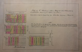
New York. Map. Color lithograph. 15" x 25". This is a rare and unusual street map showing part of SoHo in New York City. The map depicts from Broadway to Wooster Street, including Green Street, and Mercer Street, and extends from Broome Street to Prince Street to include Spring Street. As the title suggests, it depicts the William Beekmans' lots on Bayard's West Farm, showing his distribution thereof among his nephews and nieces.Issued separately, the map is most likely one..... More

New York: Geo. F. Cram, 1899. Map. Color lithograph. Image measures 10 1/8" x 11 1/8" Detailed map of Northern Brooklyn showing streets, parks and cemeteries, elevated railroads, ferry lines, canals and basins, and major landmark buildings. An index in the right margin lists elevated rail stations and political districts. In excellent condition. Color overprint slightly offset. After serving in the Union army, George F. Cram (1842-1928) joined his uncle's map business and later established his own engraving and publishing..... More

Barre: Barre Publishers, 1967. Black and white illustrations throughout. 144 pages. Square 4to, orange cloth, d.w. (spine/edges sunned). Barre: Barre Publishers, 1967. First edition. A near fine copy in a very good dust wrapper. More
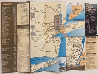
New York: DCP, 1997. Map. Lithograph. 17" x 24 3/4" "Map of New York City's private regional bus carriers, a group of private bus carriers which links New York City with many surrounding communities." Depicts bus networks throughout New Jersey, Long Island, and service to Pennsylvania. Verso includes inset maps of Midtown and Downtown, with a chart for Bus Boarding locations and their respective operators. More
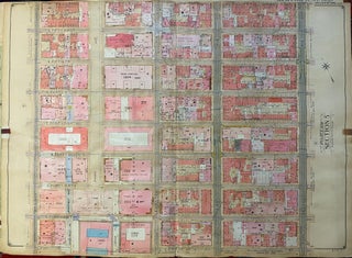
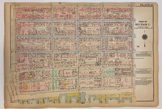
E. Belcher Hyde, 1907. Grid map. Page measures 26 1/2" x 36 1/2". This scarce grid map depicts part of Midtown Manhattan extending from Madison Avenue to Second Avenue, and from 44th St. to 51st Street. Many points of interest appear on the map, including the Waldford Astoria Hotel, the Grand Central Palace, and the Villard Houses. This particular map is from Volume Two of the "Atlas of the Borough of Manhattan, City of New York, Complete in Four Volumes"..... More
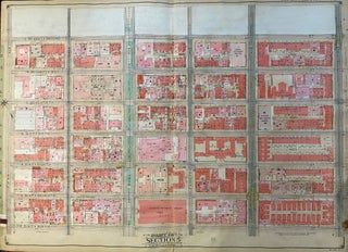
E. Belcher Hyde, 1907. Grid map. Page measures 26 1/2" x 36 1/2". This scarce grid map depicts part of the Upper East Side extending from 66th Street to 72nd Street, between 5th Avenue and 2nd Avenue. Buildings are numbered and at times, labeled, with paste-downs used to update the map as lots changed. Some notable sites on this map include Hunter College and the Park Avenue Armory. This particular map is from Volume Two of the "Atlas of the..... More
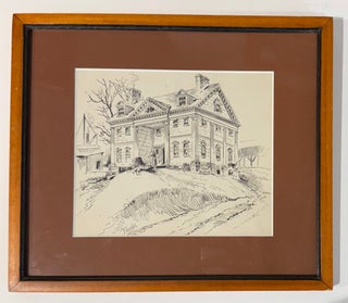
Drawing, pen and ink, signed, archival frame with wood finish 9 by 10 1/4 inches This drawing depicts the Apthorp Mansion, an enormous estate built by British Loyalist Charles Ward Apthorp in 1764. Located, as described by an annotation on the back, on 91st St near 9th Ave--now 90th and 91st Street and Columbus Avenue--the mansion was among the largest in the peaceful, rural area of Manhattan known at the time as Bloomingdale. But the peaceful life of "Elmwood," as..... More

A. T. Goodrich, 1828. Map. Uncolored lithograph. Sheet measures 24 3/4" x 16 1/4" This elegant map of New York city covers the Island of Manhattan from the Battery north as far as 86th St. with an inset in the top left featuring the northern portion of Manhattan. Part of Brooklyn is also included. The map identifies streets, parks, squares, piers, ferry lines, forts, etc. Lower Manhattan, which was more populated than the northern portions at the time, reveals far..... More
New York: John Hardy, 1870. Color lithograph. 17.5" x 39.5". Expertly repaired on verso. In very good condition. This is a large 1870 map of New York City issues by John Hardy. Actually five maps on one sheet, each map depicts a different aspect of the political landscape of the city. The large map at the bottom shows Ward Boundaries, Assembly Districts, and Election Districts. Four smaller maps on top are divided into Wards and Senate Districts, Wards and Congressional..... More

New York: John Hardy, 1870. Color lithograph. 13" x 17". Expertly repaired on verso. In good condition. This is a very unusual and rare map of New York City from the 1870 edition of the The Manual of the Corporation of the City of New York. First issued in 1831 By William Hooker and Peabody, this reissue is oriented with the southern end of Manhattan at the top, near the title, making the map appear upside-down. The map is incredibly..... More

New York: Harper's Weekly, 1870. Print. Woodcut. Sheet measures 15 3/4" x 21 3/4" Impressively detailed, this beautiful bird's-eye view looks south on Lower Manhattan, Staten Island, and Brooklyn to showcase a projection of the Brooklyn Bridge. Though not completed for almost 13 more years, construction had begun on the bridge's foundation at the time of publication. Trolleys, pedestrians, and carriages on the bridge reflect plans to create roads, train tracks, and a raised pedestrian promenade. Many ships are shown..... More

New York: Goupil & Co., 1851. View. Original color lithograph with hand coloring. Measures 27 1/4" x 39 1/4". In archival sliver-leaf frame. This 1851 dramatic bird's-eye view of mid-19th century New York City, created by German/American artists Wilhelm Heine, Julius Hermann Kummer, and Karl Emil Dopler, offers a striking depiction of the city as seen from a balloon above Governor's Island. The detailed illustration captures New York's rapid development up Manhattan Island, with the city's frontier visible in the..... More

New York: 1944. ix + 141 pages, thin 8vo, gilt-lined and lettered blue cloth; lettering very faded, cloth lightly rubbed. New York, 1944. A very good copy. More
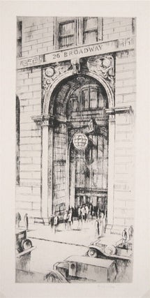
Etching. Signed in pencil. Image measures 12 1/8" x 5 1/2". This beautiful etching depicts the entrance to 26 Broadway, otherwise known as the Standard Oil Building after its original occupant. Built in 1885, the building was renovated in 1921-1928 by Thomas Hastings almost to the point of being unrecognizable. This print dates to shortly after this rebuilding and shows the elaborate vaulted entrance with a globe-shaped lamp and carved decoration. A number of cars and people stand outside, all..... More
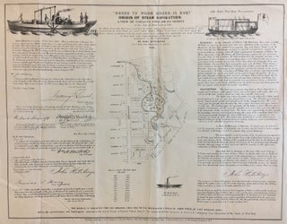
New York: John Hutchings, 1846. Map. Lithograph. 14 1/2" x 18". Fascinating map of the section in lower Manhattan from Lispenard Street and Broadway, down to Warren and Centre Streets, where the Alms House was. The focus of the map is Collect Pond, centered at the intersection of Centre and Leonard Streets. Besides the map to the left are letters to John Hutchings certifying that a steam boat was seen on Collect Pond in 1796. To the right are remarks..... More

New York City: Koch & Co, 1840. Lithographed pocket map of lower Manhattan with an inset panel of railroad connections between Buffalo and Albany. 17 1/2 x 13 1/2 inches. folding into publisher's 12mo format printed card wrappers; original hand-color in outline; light wear. New York, late 1840s From the Battery to 32nd Street with Brooklyn Heights included. More
Hello from England. I received the book today, and just wanted you to know that I'm really happy with it -- its condition is really amazing, and a lot better than I had hoped. It also happens to be a really excellent book, which helps. I also wanted to say thanks for the great packaging: it's surprisingly often that companies don't pack their books properly and they end up getting damaged during the shipping process! Kind regards,
Got it today. That is an awesome package job you did... wow! Much appreciated.