
Krushchev of the Ukraine: a Biography.
New York: Philosophical Library, 1957. 8vo, blue cloth (edge worn and spine faded). New York: Philosophical Library, (1957). A very good(-) copy. More
New York: Philosophical Library, 1957. 8vo, blue cloth (edge worn and spine faded). New York: Philosophical Library, (1957). A very good(-) copy. More
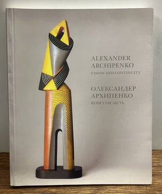
New York: Ukrainian Museum, 2005. Profusely illustrated in color and b/w. 256 pages with text in English and Ukranian. 4to, pictorial wrappers. New York: Ukranian Museum, (2005). A near fine copy. More
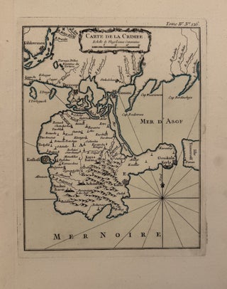
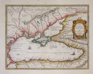
Paris: Bellin, Nicolas, 1764. Map. Copper plate engraving. Image measures 8 1/2" x 6 3/4". Disputed territory in the Black Sea with strategic deep water ports. Jacques Nicolas Bellin (1703-1772), was the official hydrographer to the French king and the first person to hold the title of "Ingenieur de la Marine of the Depot des cartes et plans de la Marine" (chief engineer of the French Hydrographical Office). More
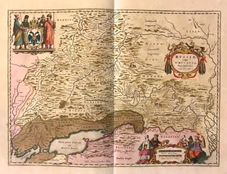
Amsterdam: Johannes Blaeu. Map. Copper plate engraving with original hand coloring with highlights in gold. Image measures 15.25" x 21". This beautiful circa 1650 map by Johannes Blaeu depicts southern Russia in detail. Covering the southwest part of Russia and Eastern Ukraine, the map extends from Vologda south to the Sea of Azov and from Mykolaiv east to the Volga River, where it discharges into the Caspian Sea. Throughout, the map notes rivers, towns, cities, lakes, and a host of..... More
Amsterdam. Map. Engraving with hand outline. Image measures 15" x 19 11/16". Beautiful map of Ukraine showing the area north of the Black Sea including Moscow, circa 1630. Latin text on verso. Willem Blaeu (1571-1638) was a prolific Dutch mapmaker who started one of the most famous map publishing firms of the 17th century. It was at this time that the Dutch controlled the map trade, and their ornate and beautiful maps had immense popularity. Blaeu was instrumental in driving..... More

London: John Cary, 1799. Map on two sheets. Engraving with hand coloring. Sheet measures 21 x 42 inches. This lovely, two-page map depicts the portion of the Russian Empire that extended into Europe in 1799, spanning from Finland on the left to Siberia on the right. The index includes towns and provinces, as well as rivers, plains, swamps and forests. The map also features graphic depictions of the territory's mountain ranges and forests. The "Bhering Strait" and the tip of..... More
Berlin: Springer, 1991. 124 illustrations, 47 tables. xxiii + 367pp., 8vo, illustrated boards. Berlin: Springer, (1991). A fine copy. More

Milan: Italgeo, 1950. Small card portfolio atlas, 13 x 9 1/2 inches. Patterned in green with brown title label and brown cloth spine. 19 color lithographs. In very good condition. Special edition Farmitalia: Milan, 1950. Special edition of Nicouline's pictorial masterpiece of 19 maps, one of all of Italy and 18 of the regions. Card wrappers titled to upper cover, historical notes and geographical descriptions of the area. Playful advertisements printed in color for Farmitalia, also by Nicouline. Maps loosely..... More
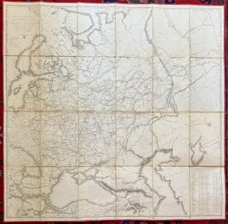
Paris: Depot Topographique Militaire, 1818. Case map. Engraving with outline hand coloring. Dissected and laid on linen, with red silk selvedge, total size 60 by 50 inches. Marbled paper slipcase with paper label and some wear. Map in very good condition, with some stains library stamp below title, otherwise in very good condition. St. Petersburg: Depot Topographique Militaire, 1818. Official large scale map of Russia in French spurred by the invasion plans. The French invasion of Russia, also known as..... More

New York: Fortune, 1941. Original map. Color Lithograph. 13 7/8" x 22 3/8" Artistically rendered map of the Soviet Union drawn by Richard Edes Harrison in May 1941. The map is drawn on a globular projection, with the terminator line (or twilight zone) depicted along the eastern border with Germany, with a notation describing the time of day - "when dawn breaks at 5:30 over the Carpathians, it is 8:00 in the Urals, noon at Vladivostok, and 4:30pm at the..... More
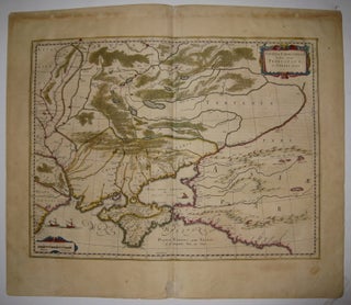
Amsterdam: Jansson, J. Map. Hand colored engraving. Image measures 14.1/2" x 18 3/4". This impressive map of the Black Sea and the Crimean Peninsula with its surrounding regions dates to circa 1650. Covers parts of the Ukraine, Russia, Georgia, Romania and Turkey. The map displayed detailed geographical and topographical features with mountains and forests beautifully rendered. Ships can be seen sailing in the Black Sea. A beautiful title cartouche adorns the right center. Published in Jan Jansson's historical atlas, based..... More
New York: Norton, 2011. Illustrated in black and white. 8vo, 1/2 cloth boards, d.w. New York: Norton, (2011). A fine copy in fine dust wrapper. More
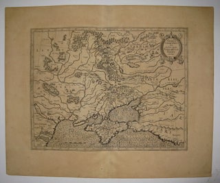
Amsterdam: Jocus Hondius. Map. Uncolored engraving. Image measures 12.25" x 15.75". Beautiful impression of Ukraine showing the area north of the Black Sea including Moscow, circa 1620. Nicely detailed geographic features. Latin text on verso. Overall toning. Full original margins. Small tear to bottom left edge. Mercator (1512-1594) was an accomplished mathematician, cartographer, globe maker and engraver but is best known for the Mercator Projection. Incorporating the newly accepted fact that the world is round, Mercator was able to render..... More
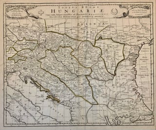
London: 1695. Map. Engraving with outline coloring. 17 1/2 x 21 1/4 inches, sheet measures 20 1/8 x 23 1/2 inches. Scarce map of Hungary and surrounding regions including Ukraine, Romania, Balkans as far west as Koningratz and Prague. Robert Morden (c.1650-1703) was a geographer, publisher, bookseller, and globe maker who collaborated with many other publishers in particular Thomas Cockerill to produce high quality atlases and maps (Burden 519-524). More

1947. Autograph musical quotation and personal note written and signed by famed cellist Gregor Piatigorsky. Inscription reads ' to Ruth with all my good wishes and friendly feelings Gregor Piatigorsky April 1947". Framed with a black and white photograph of Piatigorsky performing. Please inquire for more information. One of the pre-eminent string players of the 20th century, Gregor Piatigorsky was born in Ukraine in 1903, and died in Los Angeles in 1976. His international solo career lasted over 40 years..... More

Winnipeg: Winnipeg Art Gallery, 2008. Well-illustrated in color. 64 pages. Slim square 4to, black boards, d.w. Winnipeg: Winnipeg Art Gallery, (2008). First edition. Fine in fine dust wrapper. Scarce exhibition catalogue. More

Leningrad: Gakken/Aurora Art Publishers, 1984. Illustrated in b/w and color. 238 pages with text in English, Japanese, and Russian. Folio, decorative red cloth with gilt lettering, matching slipcase. Leningrad: Gakken/Aurora Art Publishers, (1984). Tiny stain on back bottom edge, still a fine copy in a near fine slipcase. More

Privately Printed, 1945. 309 pages. 8vo, light blue cloth with maroon spine lettering, d.w. (edgeworn, spine sunned). Privately Printed, (1945). Boldly inscribed and dated by Tucker on the dedication page. Spine cloth is slightly wrinkled, still a very good(+) copy in a very good(-) dust wrapper. Privately Printed before the first trade edition. More
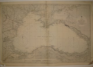
London: 1880. Sea chart. Uncolored engraving. Image measures 24.5" x 37.75". Beautiful map of the Black Sea based on Russian government surveys. Soundings in fathoms. Minor aging along edges. Expert repair to chip to lower left corner. Small tear to left edge. More
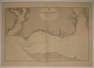
London: 1892. Sea chart. Uncolored engraving. Image measures 22 3/8" x 35.25". Beautifully detailed map of the coast line of Kherson Bay in the northern section of the Black Sea. Soundings in feet. Minor overall wear. More
Hello from Germany. The book came just 2 days after you sent it and i really enjoy it !!! It's really perfect !!! Thank you so much !!! Best Regards
An oasis in the restless city. One of my best discoveries in NYC.