Russiae, vulgo Moscovia, Pars Australis
Amsterdam: Johannes Blaeu.
Map. Copper plate engraving with original hand coloring with highlights in gold. Image measures 15.25" x 21".
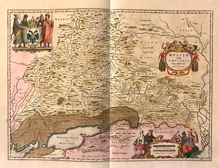
This beautiful circa 1650 map by Johannes Blaeu depicts southern Russia in detail. Covering the southwest part of Russia and Eastern Ukraine, the map extends from Vologda south to the Sea of Azov and from Mykolaiv east to the Volga River, where it discharges into the Caspian Sea. Throughout, the map notes rivers, towns, cities, lakes, and a host of additional topographic features, and renders forests and mountains in profile. The cities of Moscow, Smolensk, Vologda, Nizhniy Novgorod, and Azov are identified. Small illustrations of animals can also be seen.
Perhaps the most interesting feature of this map is the "Fossa Kamouz", a canal connecting the Don and Volga rivers. Although non-existent at the time, the idea of connecting the two rivers has a long history. The first recorded work on the canal was done by the Ottomans in the late 16th century. Today the Lenin Volga Don Shipping Canal, opened in 1952, connects the two rivers at approximately the same location.
The map includes three elaborate cartouches. The strapwork title cartouche features wild animals and credits Isaac Massa. Massa was a Dutch mapmaker who returned to Holland in 1609 after traveling to Russia and bringing back original manuscript cartographic material. These manuscripts served Blaeu and Jansson as a basis for a number of their maps.
The top left cartouche features Russian huntsmen bearing weapons surrounding the crest bearing the Russian Imperial Eagle. Another cartouche in the bottom right includes richly dressed people. The map is in good condition with minor wear along the original centerfold and some foxing throughout. Centerfold margins repaired on verso.
One of the most prolific Dutch mapmakers of his time, Willem Blaeu (1571-1638) started one of the most famous map publishing firms of the 17th century. It was at this time that the Dutch controlled the map trade, and their ornate and beautiful maps had immense popularity. Blaeu and his family worked out of Amsterdam and was instrumental in driving this dominance in his lifetime, and this legacy was continued by his sons. This series was published by his son Johannes (c. 1599-1673), who took over the business upon his father's death.
Binding: Unbound
Language: English
Price: $750.00
Item #272640