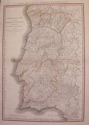
Chorographical Map of the Kingdom of Portugal Divided into it's Grand Provinces.
London: William Faden, 1797. Map. Engraving with original hand coloring. Image measures 29" x 20". Beautiful topographical details. Minor aging around edges. More
London: William Faden, 1797. Map. Engraving with original hand coloring. Image measures 29" x 20". Beautiful topographical details. Minor aging around edges. More
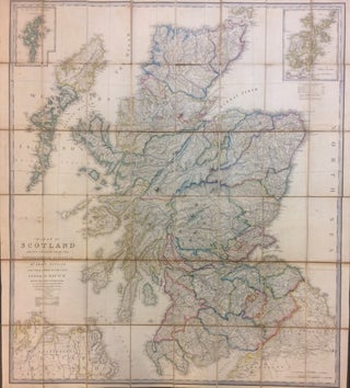
London: James Wyld, 1840. Case map. Engraving with hand coloring. 44" x 39". In very good condition. This large map of Scotland depicts the region in impressive detail. Topography is beautifully rendered by hachure, and county divisions are hand colored. Cities, rivers, towns, lakes, mountains, and roads are labeled. Insets show The Orkney Islands and The Shetland Islands. William Faden (1750-1836) was an 18th century English cartographer, engraver mapseller and publisher and 'Geographer to His Majesty & to his H.R.H...... More
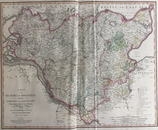
London: William Faden, 1804. Map. Engraving with hand coloring. 23" x 31". This scarce map of the disputed territory of the Duchy of Holstein in 1804 when it still belonged to Denmark. The chart notes fortified towns, market towns, castles, and other important notations which are visibly marked with a detailed key. Original hand colour. Important cities of Hamburg, Lubeck, and Eutin are identified. In 1848, there was an uprising in the Duchies of Schleswig (directly north of Holstein), and..... More
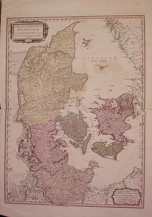
London: William Faden, 1790. Map. Engraving with original hand coloring. Image measures 28" x 20.5". Includes both Schleswig and Holstein, while today part of the former and all of the latter are northern Germany. Shows rail lines, post roads and tracks of post vessels. Some offsetting and creases to upper and lower left corners. More
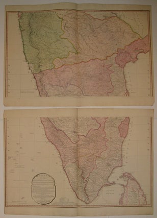
London: William Faden, 1800. Map in two sheets. Engraving with original hand coloring. Each image measures 19.5" x 32". Beautiful and rare map of India and part of Ceylon. In high detail showing geographical features and prominent roads. Delineates political boundaries. Minor aging along edges. William Faden (1750-1836) was an 18th century English cartographer and publisher. Faden is best known for his important publication of the North American Atlas, which covered a region of particular interest to him... More
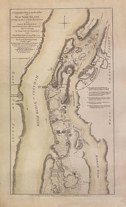
London: William Faden, 1777. Military map. Separately issued broadside on laid paper. Image 18 1/2 x 10 1/4 inches. Original color Some light toning, foxing and creases, old frame hinges, and mat burn otherwise in good condition. State 1 of Faden's battle plan map of Upper Manhattan, north of what is now 105th Street and also the coast of New Jersey and the Bronx. Shows positions and movements of forces. Also shows roads, vegetation, some buildings and a few landowner..... More
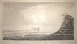
London: William Faden, 1788. Aquatint. Image measures 14 x 24.5". This beautiful view of the Mediterranean Sea shows the north side of the Rock of Gibraltar on the right. Published in 1788, the print depicts the area in the aftermath of the Siege of Gibraltar. Although the focal point of the print is ostensibly a puff of smoke arising from the land, the scene's most striking feature is its wide expanse of sky. Here, the technique of aquatint allows for..... More

London: 1793. Map. Uncolored engraving. Image measures 19" x 16.75". Foxing and toning with creases and repairs to overlay, otherwise in good condition. Additional overlay measures 6" x 9". This rare plan of Bunker Hill is one of the most prized of William Faden's battle plans of the American Revolution. Based on the work of Captain John Montressor, the map shows the American fort at Breed's Hill, the site of one of the war's most significant early battles, which was..... More
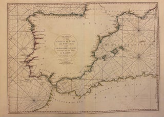
London: William Faden, 1780. Sea chart. Engraving with original hand outline. Image measures 20" x 27.5". Beautiful detailed map of the coast of Iberia and northern Africa, with rhumb lines and depths. Coastal features, cities, and rivers are extensively labeled. Regions and kingdoms are noted along the coasts, and minimal inland detail is included. In very good condition, with minor offsetting. Louis Stanislas d'Arcy De la Rochette (1731 - 1802) was a British cartographer and engraver based in late 18th..... More
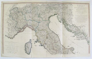
London: 1800. Map on two sheets. Engraving with original hand coloring. Each image measures 24 3/4" x 42 1/2". This large and detailed map of Italy includes the main peninsula, as well as Siciily, Sardinia, Corsica, Malta, Dalmatia, Croatia and the Adriatic. It was printed on 4 sheets, joined 2 by 2. Major roads, towns, rivers, lakes, islands, ports, harbors and topographical features are all labeled. The map is on two sheets, with the top half extending from southern Germany..... More
Wow - This is amazing - the book arrived in the post this morning! It was quicker for your book to get from New York to New Zealand, than the two books I ordered from Australia at the same time! Many thanks for that - I know it was sent by cheapest post (at my request) but somewhere along the line I got lucky. Love the book by the way - and it arrived here in such perfect condition I could almost think no one has even touched it before...
Bountiful thanks! I just returned from a business trip, and the "Armenian Art Treasures of Jerusalem" book had arrived at my office in perfect condition. Thank you for your kindness and professional courtesy!