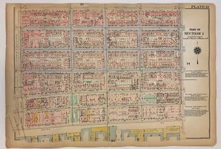
Part of Section 1 [Lower East Side, East River, Manhattan Bridge, Corlears Hook Park]
Philadelphia: G.W. Bromley, 1925. Map. Original Lithograph. 11.5 x 16.5 inches This ward map of Manhattan shows on the recto the area between East Broadway and the East River, from Manhattan Bridge and Pike Slip to Montgomery St. On the verso, it depicts from the East River at Corlears Hook Park to Grand St., East Broadway, and Montgomery St. Ward maps were used by fire insurance companies to determine the potential hazards of particular buildings. Color-coding indicates building materials: pink..... More
![Item #332592 Plate 106 and Plate 105, Part of Section 5 [Upper East Side]. George W. BROMLEY,...](https://argosybooks.cdn.bibliopolis.com/pictures/332592.jpeg?width=320&height=427&fit=bounds&auto=webp&v=1765489669)
![Item #332591 Plate 107 and Plate 108, Part of Section 5 [Upper East Side]. George W. BROMLEY,...](https://argosybooks.cdn.bibliopolis.com/images/noimage.png?auto=webp)
![Item #332593 Plate 138 and Plate 139, Part of Section 7 [Morningside Heights]. George W. BROMLEY,...](https://argosybooks.cdn.bibliopolis.com/pictures/332593.jpeg?width=320&height=427&fit=bounds&auto=webp&v=1778524975)
![Item #301369 Plate 163, Part of Section 8 [Washington Heights]. George W. BROMLEY, Walter S. BROMLEY](https://argosybooks.cdn.bibliopolis.com/pictures/301369.jpg?width=320&height=427&fit=bounds&auto=webp&v=1626466418)