
The Decorative Arts and Crafts of Nantucket.
New York: Dodd, Mead & Co., 1987. 75 color and 209 b/w illus. 4to, 1/2 blue cloth, d.w. New York : Dodd Mead, (1987). Very good. More
New York: Dodd, Mead & Co., 1987. 75 color and 209 b/w illus. 4to, 1/2 blue cloth, d.w. New York : Dodd Mead, (1987). Very good. More
Garden City: Natural History Press, 1964. Illus. 8vo, two-toned cloth, d.w. slightly chipped, top of cloth spine with small tear. Garden City: Natural History Press, 1964. More
New York: Crown, 2004. A few illustrations. 141 pages, thin 12mo, boards, d.w.; a few pages dog eared. New York: Crown, (2004). First edition. A near fine copy in a near fine dust wrapper. More

Paris: Cuchet, 1787. Traduites de l'Anglois. 5 copper engraved folding maps. 4 plates. 3 vols. 8vo, later 1/2 sheep; (spines rubbed, board edges of all volumes lightly worn, light foxing to all title pages, some light foxing to margins of text, not affecting maps). Paris: Chez Cuchet, 1787. First Edition. Very good (+). A tight, bright set. "best French edition-and most complete of all editions. Description of American life of great influence in attracting European immigration in the post-revolutionary period..... More
Intro. by Stuart P. Feld. Color frontis., 266 illus. in color and b/w, 268pp., 4to, cloth, d.w. Nantucket: Nantucket Historical Assoc., (1982). Near Fine. Limited Edition, one of 2000 numbered copies signed by the author. More
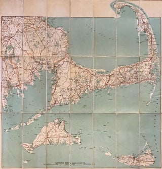
Boston: Geo. H. Walker & Co., 1906. Map. Colored lithograph. Sheet measures 30.5" x 29.5". This beautiful 1906 pocket map of Cape Cod, Nantucket, and Martha's Vineyard from 1906 was issued by George H. Walker & Co. Specifically designed for the automobile traveler, it identifies state roads, good automobile routes, electric railways and other routes. Covers from Bridge Water to Nantucket Island. Beautifully detailed, it also notes several towns, cities, bays, islands, ferry routes, lighthouses, shoals, banks, and several other..... More
8vo, cloth, d.w. N.Y.: Summit, (1979). vg. More

Nantucket: Nantucket Historical Association, 1994. Illustrated in black and white and in color. 107 pages. Slim 4to, glossy pictorial wrappers (lightly edgeworn). Nantucket: Nantucket Historical Association, (1994). Internally clean and tight. Very good(+). More
New York: Dover, 1979. 180 Illus. 4to, pr. wrs. New York: Dover, (1979). vg. More
Nantucket: Wesco Publishing, 1994. Illus. 8vo, pr. wrs., small dampstain to right margins throughout. Nantucket: Wesco Publishing, 1994 Presentation copy from Robert F. Mooney to Wendell (Garrett). More
Washington: National Geographic Society, 1981. Many color Illus. 4to, blue boards, d.w. lightly soiled. Washington: National Geographic Society, (1981). Very good. More

New Bedford, Massachusetts: New Bedford News Co., 1947. Map. C.T. ART-Colortone print. Measures 6 7/8" x 10 3/4" This charming mid-century map of Martha's Vineyard and Nantucket was printed on a giant postcard, with a lovely pictorial border featuring 15 color photographs of major points of interest on the islands. Shows major roads, airports, ferry routes from New Bedford, and towns. Dated according to production number on verso (D8685). In very good condition, with wear to top edge of paper..... More
Wow - This is amazing - the book arrived in the post this morning! It was quicker for your book to get from New York to New Zealand, than the two books I ordered from Australia at the same time! Many thanks for that - I know it was sent by cheapest post (at my request) but somewhere along the line I got lucky. Love the book by the way - and it arrived here in such perfect condition I could almost think no one has even touched it before...
The book was in my mailbox when I got home last night. Wonderful condition for a 40-year-old book. Nice condition in any case. I am very pleased. Thank you. A bit of trivia: You are only the second seller in six years not to tape the pull strip so it can't be used! Congratulations. Take care, and many, many thanks. I was really looking forward to this one, and you didn't disappoint.