
William Merritt Chase: Summers at Shinnecock, 1891-1902
New York: Universe, 1987. Illustrated, mostly in color. 95 pages. Slim oblong 4to, glossy pictorial wrappers. New York: Universe & National Gallery of Art, 1987. Fine. More
New York: Universe, 1987. Illustrated, mostly in color. 95 pages. Slim oblong 4to, glossy pictorial wrappers. New York: Universe & National Gallery of Art, 1987. Fine. More

Bryn Mawr: Franklin Press, 1956. 98 photo Illus., folding map. 276pp. 8vo, blue cloth, d.w. chipped and lightly soiled, otherwise very good. Bryn Mawr: Franklin Press, (1956). Yachting cruises on Chesapeake Bay and Long Island Sound starting in 1897. This volume is a reprint of the Bryn Mawr, 1909 edition. More
Port Jefferson: Times Steam Job Print, 1888. This volume contains the entire records from 1798 to March, 1856 inclusive, copied from the original records...and published by the authority of the town. xxix, 5-551pp. (with no loss of pages). 8vo, original green cloth, cloth lightly soiled, last blank page chipped in corner. Port Jefferson: Times Steam Job Print, 1888. First Edition. More
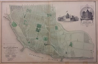
New York: Beers, Comstock, & Cline, 1873. Map. Lithograph with original hand coloring. Sheet measures 15 1/2" x 24". This 1873 map by Frederick W. Beers shows Sea Cliff Grove in the Glen Cove in Suffolk County. The map beautifully renders topographic features, such as swamps, harbors, and lakes, and notes streets, wards, settlements, wards, major buildings, landowners, bridges, wharves, railroads, cemeteries, etc. Shows from Main Avenue down to Hempstead Harbor. Also includes two small insets, one of a famous..... More

New York: Beers, Comstock, & Cline, 1873. Map. Lithograph with original hand coloring. Sheet measures 24" x 15". This 1873 map by Frederick W. Beers shows Far Rockaway from Central Avenue to the Atlantic Ocean. Railroads, streets, buildings, and features such as ice ponds and hills are marked with detail. Included in Beers' Atlas of Long Island, New York (1873). Verso shows Westville or North West Point with an inset of Little Neck. Map has some visible offsetting but otherwise..... More

New York: Beers, Comstock, & Cline, 1873. Map. Lithograph with original hand coloring. Sheet measures 15 1/2" x 30 1/8". This 1873 map by Frederick W. Beers shows the village of Glen Cove in Oyster Bay, which at the time was part of Queens County. The map beautifully renders topographic features, such as hills, harbors, and lakes, and notes streets, wards, settlements, wards, major buildings, landowners, bridges, railroads, cemeteries, etc. Shows from Glen Cove Landing in the west to Elm..... More

New York: Beers, Comstock, & Cline, 1873. Map. Lithograph with original hand coloring. Sheet measures 15 1/2" x 12". Detailed map of Greenport from in the Town of Southold in Suffolk County. The map beautifully renders topographic features, such as swamps, harbors, and lakes, and notes streets, wards, settlements, wards, major buildings, landowners, bridges, wharves, railroads, cemeteries, etc. Shows from Sterling Creek and Bridge Street down to Clark Street and includes an inset from Clark Street down to Fanning's Point..... More
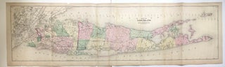
New York: Beers, Comstock, & Cline, 1873. Map. Lithograph with original hand coloring. Sheet measures 15.5" x 54". Shows some foxing. Shows some tears and chips at edges, image unaffected. This 1873 map by Frederick W. Beers shows all of Long Island. Includes part of New Jersey, Westchester and Fisher's Island. Fish oil factories are noted as well as early RR lines. Included in Beers' Atlas of Long Island, New York (New York: Beers, Comstock, & Cline, 1873). Frederick W...... More

New York: Beers, Comstock, & Cline, 1873. Map. Lithograph with original hand coloring. Sheet measures 15 1/2" x 12". Detailed map of North Hempstead, with inset maps of Great Neck and Roslyn, at the time located in Queens County (now Nassau). The map beautifully renders topographic features, such as ponds, harbors, and lakes, and notes streets, wards, settlements, wards, major buildings, landowners, bridges, wharves, railroads, cemeteries, etc. Shows Manhasset bay to the west as far south as eighth avenue. Also..... More
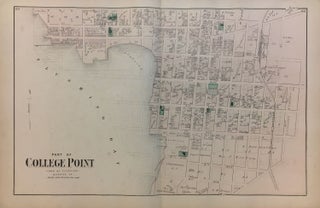
New York: Beers, Comstock, & Cline, 1873. Map. Lithograph with original hand coloring. Sheet measures 15.5" x 24". Shows some small tears at edges, image unaffected. In very good condition. This 1873 map by Frederick W. Beers shows College Point, Flushing, Queens, from River Street and Flushing Bay to 21st Street, and from 2nd Avenue to 9th Avenue. Verso is blank with manuscript notes in pencil. Included in Beers' Atlas of Long Island, New York (New York: Beers, Comstock, &..... More
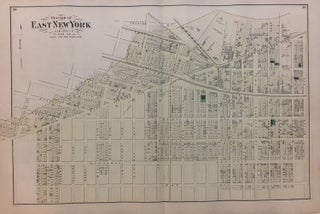
New York: Beers, Comstock, & Cline, 1873. Map. Lithograph with original hand coloring. Sheet measures 15.5" x 23.5". Shows some small tears at edges, image unaffected. In very good condition. This 1873 map by Frederick W. Beers shows the East New York neighborhood of Brooklyn, at the convergence of Brownsville, East New York and Cypress Hills. Verso shows details of Gravesend and Fort Hamilton. Included in Beers' Atlas of Long Island, New York (New York: Beers, Comstock, & Cline, 1873)..... More

1871. Map. Engraving with original hand coloring. 15 1/2 x 24 inches. Detailed map of the neighborhood of Woodhaven in Jamaica, Queens County, New York. Includes an inset map of South Woodhaven. Union Race Course, Silver lake, churches, and property owners are marked. Verso shows Freeport, Greenwich Point, Springfield Store, Willow Tree Station, and Inglewood. Map is in good condition, some faint offsetting is visible. Frederick W. Beers (flourished 1858-1929) came from a family of surveyors, cartographers and publishers originally..... More
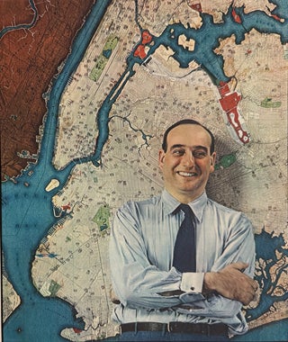
New York: Fortune, 1938. Print. Offset Lithograph. 12 7/8" x 11 1/8" This portrait of Robert Moses - notorious urban planner and public official who was highly influential in shaping the city of New York - features him posing in front of a large wall map of New York City. Photographed by Fernand Bourges for the June 1938 issue of Fortune magazine. See #33235 for map of Moses' projects, printed in the same issue as this portrait. More
Bridge Hampton Village Improvement Society, 1974. Illus. 108pp. 8vo, spiral bound, wrs. lightly soiled. N.p.: (Bridge Hampton Village Improvement Society, 1974). Very good. More
New York: Burr Printing, 1893. This volume contains the entire records from 1856 to December, 1895, inclusive, copied from the original records...and published by the authority of the town. xxxviii, 1081pp. Very thick 8vo, original brown cloth, cloth lightly soiled, corners lightly bumped, otherwise very good. New York: Burr Printing, 1893. More
Bridgehampton: Ernest S. Clowes, 1953. 8vo, red cloth, spine sunned. Bridgehampton: Ernest S. Clowes, (1953). Very good. More

New York: COLTON, G. W. and COLTON, C. B., 1869. Map. Engraving with hand coloring. Sheet measures 24 1/2" x 24 3/4" Rare elegant large scale map of the New York metropolitan area, including parts of New Jersey, Long Island, Connecticut, and Westchester and Rockland counties. Counties, townships, cities, post offices, and neighborhoods are labeled. Turnpike and common roads, as well as canals and railroads are indicated. Centered on the island of Manhattan, the map features a circular shape to..... More

New York: Coverdale & Colpitts, 1965. Oblong folio, 11 1/2 x 18" Red paperback, 69pp with 47 exhibits. White plastic binding comb. Stains to cover and ink inscription but otherwise in very good condition. Sponsored by the City of New York, Borough of Queens, New York city transit authority, Nassau County, Tri-State Transportation Committee and the Long Island Railroad with assistance from Housing and Home Finance Agency. More
New York: Abrams, 2004. Numerous black & white photographic illustrations with several in full color. Tall 4to, beige cloth. New York: Harry N. Abrams, 2004. Second edition. A fine copy. More
illus. 63pp. 4to, cloth. (Cold Spring Harbor): Whaling Museum, (1966). vg. More
Wainscott: Medway Press, 1975. Illus. 8vo, pr. wrs. Wainscott: Medway Press, (1975). Very good. More
Charleston: Arcadia Publishing, 2003. Many photo Illus. 8vo, pr. wrs. (Charleston): Arcadia Publishing, (2003). Fine. More
New York: Privately Printed, 1914. Frontispiece portrait and many other illustrations, some with lettered tissue guards , facsimile letters and documents. 275 pp., tall 8vo, grey cloth (lightly rubbed). New York: Privately Printed, 1914. First Edition. Scarce. A personal memoir of the horse racing and trotting sport as it evolved in New York through the 19th century. The author's family and he owned and raced thoroughbreds, and trotting horses, and were key members in the Union Course, Long Island. Of..... More

New York: Frank Leslie's Illustrated Newspaper, 1890. Print. Woodcut engraving. Sheet measures 11" x 15 1/2" This print, published on October 25, 1890, depicts a duck farm in Long Island. An smaller illustration in the upper right shows farmers feeding the ducklings. Some chips and tears to the edges, evenly toned. Frank Leslie's Weekly, originally known as Frank Leslie's Illustrated Newspaper, was a leading American illustrated news magazine published between 1852 and 1922. Its pioneering use of mass-market reproduction techniques--wood..... More
Hallo from Bavaria, Book has been received. I am highly pleased. All the best wishes.
My book order was received today in good time and the book is in wonderful condition and very thoughtfully wrapped. Thank you! 5 Stars.