
Fire in Beirut: Israel's War in Lebanon with the PLO.
New York: Stein and Day, 1984. 261pp. 8vo, 1/2 red cloth, d.w. New York: Stein & Day, (1984). Very good. More

New York: Stein and Day, 1984. 261pp. 8vo, 1/2 red cloth, d.w. New York: Stein & Day, (1984). Very good. More
New York: Haymarket Doyma Inc., 1988. 101 pages. Thin 8vo, orange leatherette with gilt lettering at spine, d.w. (worn at head of spine). New York: Haymarket Doyma Inc., (1988). First Edition. A fine copy in a near fine dust wrapper. More
Beirut: Les Editions Dar an-Nahar, 1994. Many illustrations (color and b/w), some mounted. 240 pages + appendix. Folio, stamped blue silk cloth, dust wrapper; corners lightly bumped. Beirut: Les Editions Dar an-Nahar, 1994. Avec les compliments de la Banque Audi. First edition. A very good(+) copy. Inscribed on presentation page sponsored by Banque Audi: "Dear [...] with lots of best wishes May and Raymond Audi" More

London: Laurie & Whittle, 1764. Map. Engraving with hand colored outline. Image measures 19 3/4" x 23 3/4" Beautifully detailed map of modern-day Turkey as it was in ancient times, extending from the Aegean Sea to Armenia. Regions are labeled with classical place names, and cities, rivers, and major topographical features are shown. Mountains are depicted pictorially. In very good condition, with some staining to upper margin near centerfold, and very faint offsetting. Jean Baptiste Bourguignon d' Anville (1697-1782) was..... More
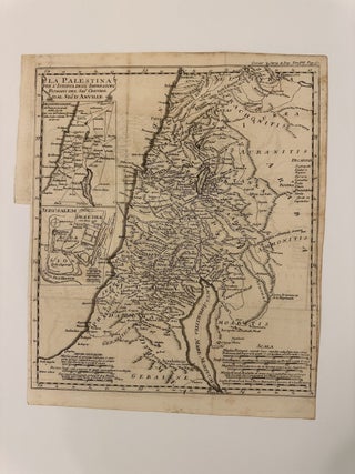
Map. Uncolored engraving. Image measures 13 3/8" x 11 3/4" This scarce edition of D'Anville's map of Palestine was published in volume 7 of Jean-Baptiste Louis Crevier's "Storia degli Imperatori Romani" or "The History of the Roman Emperors," first printed in 1750. The map, based on D'Anville's work, depicts the region comprising modern day Palestine, Israel, Jordan, and Lebanon. Regions, cities, rivers, and lakes are labeled according to Roman place names. Mountains are rendered pictorially. Two insets in the left..... More

Paris: Joseph Nicolas De l'Isle, 1764. Map. Engraving with hand color. Image measures 22" x 16.25" This is a lovely 1764 map of Syria and Lebanon by Joseph Nicolas De l'Isle. Part of the Ottoman Empire at the time, the map extends from the Asia River in the south of modern day Turkey south as far as Sidon in modern Lebanon. Shows incredible detail with important cities and mountains depicted pictorially. Also notes towns, rivers, lakes, and other important features..... More
Camden: Thomas Nelson, 1970. Map, many illus., 8vo, brown cloth, d.w., Camden, N.J.: Thomas Nelson, (1970). Very good. More
New York: Random House, 1982. Illustrated in black and white. 392 pages. 8vo, burgundy cloth-backed boards, d.w. (spine sunned, worn). New York: Random House, (1982). A very good copy in a very good dust wrapper. More

b/w illus., 308pp., 8vo, two-toned boards, d.w. New York, (1991). Near fine. Inscribed and signed by the author on the half-title. More
Princeton: Karz-Cohl, 1983. Introduction by Abba Eban. 136 pages. 8vo, glossy printed wrappers. Princeton: Karz-Cohl, (1983). First Edition. Fine. More

New York: Norton, 2008. 303pp. 8vo, two-toned boards, dust wrapper. New York: W.W. Norton, (2008). First Edition. Near fine. More
London: BCA, 1993. Illus. 524pp. 8vo, blue cloth, d.w. lightly soiled. London: BCA, (1993). John McCarthy's ordeal as a British hostage in Beirut, Lebanon from 1986 to 1991. More

London: Jonathan Cape, 2010. Texts by Barnaby Rogerson. Profusely illustrated with large well-printed b.w photographs. 272 pages. Large oblong 4to, pictorial boards, d.w London: Jonathan Cape, (2010). First edition. Fine in near fine dust wrapper. Scarce. Spanning several trips over a number of years, McCullin has been to explore the southern fringes of the Roman Empire. Southern Frontiers is divided into two parts. The first, The Levant, begins in the ruins of Baalbek in Lebanon and follows a trail to..... More
Dubai: Lawrie Shabibi, 2013. With color illustrations throughout. 36 pages. 4to, pictorial wrappers, loose as issued. (Dubai: Lawrie Shabibi, 2013). A very good(+) copy, light scuffing and sunning to spine. More
New York: Gilbert & Sons, 1994. 294 pages, 8vo, gilt stamped brown cloth, dust wrapper (just lightly rubbed). New York: Gilbert & Sons. A fine copy in a near fine dust wrapper. Presentation copy signed Liston on front free endpaper. More

London: Day & Son, 1855. View. Color lithograph. Sheet measures 7 7/8" x 11 1/4" From Roberts's octavo edition of "Views in the Holy Land...Egypt and Nubia." Born in Scotland, Roberts (1796-1864) gained renown as a landscape artist from documenting his extensive travels through Spain and the Near and Middle East. His most well known work, "Views in the Holy Land...Egypt and Nubia" illustrates Roberts' trip in 1838-39. The subsequent publication was issued in 41 parts between 1842 and 1849..... More

NP: Eric Baschet, 1979. Richly illustrated with b/w photographs. Unpaginated. Thin 4to, b/w pictorial boards. NP: Eric Baschet, (1979). A few pages unopened. A fine copy. Limited edition of 250 copies. More
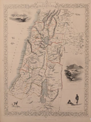
London: Tallis, John, 1851. Map. Steel engraving with original outline color. Image measures 13 3/4" x 10 1/8" Beuaituflly detailed map of Palestine in 1851, showing the Kaza subdivisions, the administrative divisions of the Ottoman Empire. Includes historically and culturally relevant vignettes such as views of Jaffa and Nazareth, a gazelle and Natives of Mount Lebanon. Topography is depicted by hachure. In very good condition, with minor chips and tears to right margin, not affecting the image. John Tallis (1817-1876)..... More
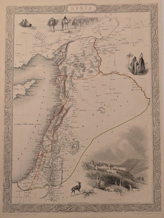
London: Tallis, John, 1851. Map. Steel engraving with original hand colored outlines. Image measures 13 1/2" x 9 7/8" This map of Syria covers the Eastern Mediterranean coast extending from the Euphrates River to Petra. The region is abundantly labeled with the names of cities, rivers, roads, and topographical features. Regional divisions are outlined in hand-color. The decorative vignettes, illustrated by H. Warren and engraved by J. Rogers, depict Baggage Camels, Arabs, and the city of Jerusalem. The map is..... More
New York: Knopf, 1982. Translated by Miguel Acoca. 167pp., thin 8vo, cloth-backed boards, d.w. New York: Alfred A.Knopf, 1982. First edition. Near fine copy in a very good dust wrapper. More
I write to you these few words to tanks for your friendly service and to notify the correct arrive in Rome of my two maps (New York and Paris). Tank you and good bye to my next visit in NY.
Your wonderful antique book Third Year of the War" written by Edward A Pollard and published by Charles B Richardson arrived Today in Australia. I'm very excited to be the new owner of this Historical record of the American Civil War - this wonderful book has found a good home. Kindest Regards