
The Coming of the Italian-Ethiopian War
Cambridge: Harvard University Press, 1967. Map. 404pp. 8vo, gray cloth, d.w. with a small tear and lightly soiled. Cambridge: Harvard University Press, 1967. More
Cambridge: Harvard University Press, 1967. Map. 404pp. 8vo, gray cloth, d.w. with a small tear and lightly soiled. Cambridge: Harvard University Press, 1967. More
London: Macmillan, 1871. Illustrated with 25 black & white plates. 568 pages. Short, very thick 8vo, rebound in plain green library cloth with gilt- lettered spine. London: Macmillan and Co., 1871. Third edition. Near fine. More
New York: Abrams, 1990. Text by Graham Hancock. Illustrated with 328 excellent photographs, including 244 in color; 75 drawings. 320 pages. Folio, gray silk, d.w. New York: Abrams, (1990). First American edition. Bump on bottom edges, still a near fine copy in a near fine dust wrapper. More
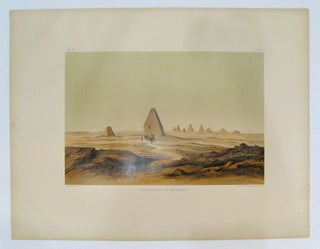
Buffalo, NY: American Polytechnic Company, 1887. Color lithograph. Image measures 12" x 18". Sheet measures 21" x 27 1/4". Plate XII. This color lithograph depicts the Ethiopian pyramids located on the western side of Mount Barkal. Published in 1887, the scene clearly demonstrates the vast difference in architectural style between these Ethiopian pyramids and their more famous Egyptian brethren, the former being taller, narrower, and steeper in slope than the latter. A hazy green sky floats above the small pyramids..... More
New York: Paul Holberton Publishing, 2005. Profusely illustrated in color. 128 pages. 4to, pictorial wrappers (lightly scuffed). New York: Paul Holberton Publishing, (2005). A near fine copy of this uncommon exhibition catalogue. Introduction by C. Griffith Mann. More
Zurich: Atlantis, 1972. Text in German. Several maps, black & white and color illustrations throughout. 172 pages. Large 4to, orange cloth with gilt lettering at the spine, pictorial d.w. (edgeworn, torn at the front). Zurich: Atlantis, (1972). A near fine copy in a very good(-) dust wrapper. More
Trenton: Red Sea, 1989. 375 pages, 8vo, red cloth, d.w. Trenton: Red Sea Press, (1989). First Edition. Presentation by the author on the fly-leaf. More
Addis Ababa: Holy Trinity, 1973. More than 200 crosses depicted in black-and-white photographs, plus several in color. Oblong 8vo, blue cloth, d.w.; dust wrapper worn, with chipping along bottom edge. Addis Ababa: Holy Trinity Cathedral, (1973). First edition. A very good(+) copy in a very good(-) dust wrapper. More
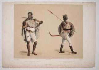
Arthus Bertrand. Lithograph with hand-coloring. Image measures 11.5" x 13.75". This plate from Lefebvre's "Voyage en Abyssinie" features two figures against a yellow background showing the local costume of Abyssinie, now Ethiopia. The figure on the left wears traveling clothes and is carrying a rifle. The figure on the right is outfitted for battle with a spear and shield. The print is in good condition, with browning and tears limited generally to the margins where they do not affect the..... More
London: Merlin Press, 1964. Translated from the French by Claire Pace. Color and black & white plates throughout. 120 pages. Large 4to, gray cloth with red lettering and overlaid illustration, black slipcase (several small tears). London: Merlin Press, (1964). A fine copy in a very good(+) slipcase. More
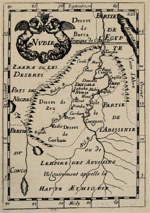
Paris: Denys Thierry, 1683. Miniature map. Uncolored copper plate engraving. Image measures 5 3/4" x 4". Sheet measures 8 1/4" x 5 1/2". This miniature map of northern Ethiopia published in 1683 is from the original French edition of Manesson-Mallet's "Description de L'Univers." The map shows the part of the Abyssinian Empire known as Nubia, which encompassed the region west of the Red Sea around the Nubia and Nile Rivers, below the Tropic of Cancer. Decorative title cartouche at upper..... More
New York: Dutton, 1966. Illustrated in black and white. 318 pages. 8vo, green cloth with orange lettering. New York: Dutton, 1966. First Edition. A touch faded at head of spine, else a near fine copy. More

London: Herman Moll, 1728. Map. Engraving with original hand coloring. Image measures 8 x 10 3/4 inches. Fascinating map of West Africa spanning from modern-day Senegal to Cameroon. Evidence of European colonization and slave trade is abundant on this map, with English, Dutch, and Danish territories marked, resources such as gold mines labeled, and "slave coast" marked in southern Guinea. The term "Negroland" was only used briefly to refer to this area during the Age of Exploration, further exemplifying the..... More
London: Cadell, 1818. 464 pages, 8vo, full blind stamped brown calf, red leather spine label. London: T. Cadell, 1818. Third Edition. Very good (+). More
New York: Reynal, 1959. Illustrated. 190 pages. 8vo, cloth, d.w. New York: Reynal, 1959. More
Munich: Hanns Reich, 1963. Text in German. Color and black & white photographic illustrations. 83 pages. Thin 4to, black cloth-backed glossy pictorial boards. Munich: Hanns Reich Verlag, (1963). A very good copy. More
London: 1970. Illustrated, some in color. 8vo, cloth, d.w. London, (1970). A very good (+) copy in a very good (+) dust wrapper. Travel to North Africa and Ethiopia. More
Just wanted to let you know that I got your name off an envelope from July 1939. Your store looks wonderful and very cozy. I live in McDonough,Georgia and at 71 I will probably not get to visit. But what a store!
I am very pleased that you took the time to consult me on the price before just adding the additional shipping cost onto my credit card. Ordering things on-line, one runs into all kinds of less-than-considerate business practices... Thanks again for taking the time to contact me. I'm looking forward to the book.