
The Land And Wildlife Of South America.
color and b/w illus. 4to, pict. boards. New York, (1964). vg. Life Nature Library. More
color and b/w illus. 4to, pict. boards. New York, (1964). vg. Life Nature Library. More
New York: Aristide D. Caratzas, 1987. 79 pages. Slim 8vo, burgundy cloth with silver lettering. New Rochelle: Aristide D. Caratzas, (1987). Reprint of the original 1912 edition. Fine. More
New York: David McKay, 1958. Illus. 8vo, black cloth, d.w. very torn, cloth dampstained, corners of cloth bumped. New York: David McKay, (1958). Author's four year journey in South America with his family. He travelled down the Amazon in Western Brazil to the Rio Negro and on to the Orinoco River. More
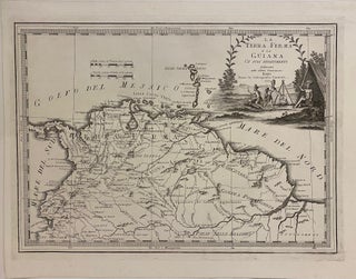
Rome: G. M. Cassini, 1798. Map. Engraving. Image measures 13 1/2 x 18 3/4" This hard to find map by Giovanni Maria Cassini dates to 1798. It details the northern coast of South America, showing Colombia, Venezuela, Guyana, Suriname, French Guiana, Ecuador, and parts of Panama, Peru, and Brazil. The map labels colonial cities and towns, and feature extensive references to indigenous groups. Rivers are prominently depicted, and topography is rendered pictorially. The most striking feature of the map is..... More
8vo, cloth, d.w. London: Heinemann, (1985). vg. More
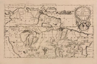
1695. Map. Engraving 13 x 19 3/4 inches. Beautifully engraved map of the northern half of the South American continent. It describes the Amazon basin with Pacific, Caribbean and Atlantic coasts delineated, large armorial cartouche of Giovanni da Verrazzano, the dedicatee, surmounted by title within garland, scale of Italian miles within smaller decorative ribbon cartouche connected to a playful sea monster, topographical features of mountain ranges and water courses elegantly engraved, numerous depictions of indigenous peoples including settlements and farming..... More
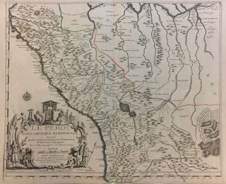
Paris: 1719. Map. Engraving with original hand outline color. Image measures 19 x 23". Sheet measures 20 x 28". Unusual map of Peru from the early 18th century. Includes part of Ecuador, Bolivia and Brazil, based on Jesuit activity in the area. Amazon rain forest is visualized with a dynamic design. Cartouche describes the mining industry. Nicolas de Fer (1646-1720) was a prolific cartographer, engraver and publisher who took over the family map business from his mother when she retired..... More
New York: Simon & Schuster, 1954. Illustrated. 353 pages. Thick 8vo, cloth. New York: Simon & Schuster, 1954. More
New York: Farrar Straus & Giroux, 2010. Illustrated in black and white. ix, 322 pages. 8vo, black boards, d.w. New York: Farrar, Straus and Giroux, (2010). American First Edition. Slightly cocked, small black ink mark at bottom outer edge of text block -- still internally clean and tight. A very good(+) copy in a near fine dust wrapper. More
color illus. 8vo, cloth, d.w. New York, (1973). Presentation copy. More
illus. 4to, cloth, d.w. London: Verso, (1989). vg. More

London: Verso, 1989. Illustrated in black and white. x, 266 pages. 8vo, green boards, d.w. London: Verso, (1989). Near fine in a near fine dust wrapper. More
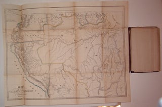
U.S. Government, 1854. Case Map. Lithograph. Image measures 9.5" x 5.75". Case map of three maps pertaining to the Amazon River and it's surrounding area. Embossed cloth cover with gilt title; on the back is embossed "House Document". Some wear to spine and front cover, but all three maps are attached. First map is "Map of the Valley of the Amazon" (by H.C. Elliot), with lithographed color outline. Minor scattered foxing and stains from original glue to booklet. Measures 17.75"..... More
New York: Harper, 1964. 148 illus., 48 in full color. 4to, two-toned cloth, d.w. chipped. New York: Harper & Row, (1964). Study of the Amahuaca Indians of Peru. More
illus. 8vo, cloth-backed boards, d.w. New York, (1989). More
color and b/w illus. 8vo, cl.-backed bds. Boston, 1931. A novel set in the Amazon. More

London: Thames & Hudson, 1970. 75 photographs, 42 line drawings, 15 maps. 256 pages, 8vo, cloth, d.w.; dust wrapper price clipped. London: Thames & Hudson, (1970). A near fine copy in a near fine dust wrapper. More
392 color illus. square 4to, cloth, d.w. (Washington): National Geographic, (1982). vg Studies of Indians of Mexico, the Andes, and the Amazon. More
New York: Century, 1927. Color folding map, and some b/w illustrations. 526 pages. 8vo, green cloth (head of spine significantly repaired; pages toned). New York, (1927). A good copy. More
New York: Scribner, 2010. Map, some black & white photographic illustrations. ix, 273 pages. 8vo, green cloth-backed white boards with gilt lettering at spine, pictorial d.w. New York: Scribner, (2010). Pages toned, still a fine copy in a fine dust wrapper. More
illus. 8vo, cloth, d.w. N.Y.: Funk & Wagnalls, (1968). vg. More
It has been a very l-o-n-g time in ordering another book from you but nonetheless very happy to have done so. My book arrived today in perfect condition and I do thank you for the prompt shipping along with the aforementioned condition. I still miss not having a decent bookshop in my neck of the woods but I am grateful to still have the ability to use my computer and search engine to find such treasures such as sellers like you and find items to purchase for my various interests!
I have received my book, and it is a beautiful copy! It was very lovingly wrapped, and arrived in great shape. Thank you so much! I will definitely consider you for my next order.