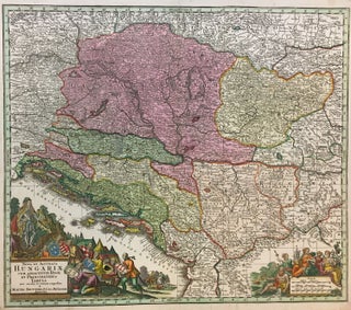
Nova et Accurata Hungariae Cum Adiacentib. Regn. et Principatibus Tabula
Augsburg. Map. Hand colored engraving. 19 3/4" x 22 3/4". Fine antique map of Hungary and surrounding areas shown in just one configuration of the many possible snapshots of the 18th century border changes in the region. Depicted around 20 years following the second Battle of Mohacs which, through the end of the 17th century led to Transylvania becoming a part of Hungary again. By 1718, only a few years prior to this map, the entire Kingdom of Hungary had..... More