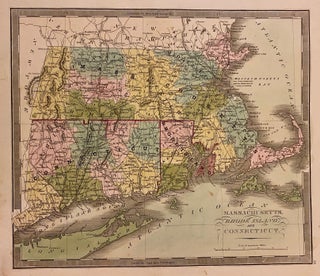
Maine.
Brattleboro: G. R. French, 1849. Map. Engraving with original hand coloring. Image measures 12 1/2" x 10 3/4" Classic map of Maine divided into counties. Shows many place names, major routes, railroads, waterways and topographical details. Greenleaf's delicate treatment of this map complements the natural beauty of Maine's geographical elements. Unlike earlier editions of this map, the northern boundary line is colored to its present-day border as established in the Treaty of 1842, previously labeled as "Boundary as recommended by..... More