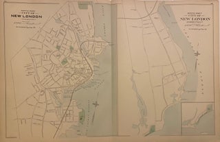
City of New London, Connecticut.
Boston: D.H. Hurd & Co., 1893. Map. Lithograph with hand coloring. Image measures 18 x 28". This double-page map of New London, Connecticut shows the north and south parts of the city on two sheets. The north part extends from a cemetery near present-day Riverside Park, to Fort Trumbull. The south part extends from Green's Harbor to Ocean Beach Park, with an additional inset of Ocean Beach Park. Significant roads, railroads, topographical features, buildings, and landmarks are all labeled. The..... More