
Labyrinths Of Iron; A History of the World's Subways.
illus. 8vo, cloth. N.Y.: Newsweek, (1982). vg. More
illus. 8vo, cloth. N.Y.: Newsweek, (1982). vg. More
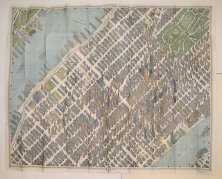
New York: Pictorial Maps, Inc., 1963. Map. Colored lithograph. Image measures 32 1/2" x 41 1/2". Original visitors guide booklet measures 9 3/8" x 5". This pictorial map of New York City was included as part of the "Official World's Fair Edition" map and guide for the 1964 World's Fair. As the description printed on the inside of the outer sleeve notes, this bird's-eye-view of midtown Manhattan was "the first such map to be drawn of the city since 1866."..... More
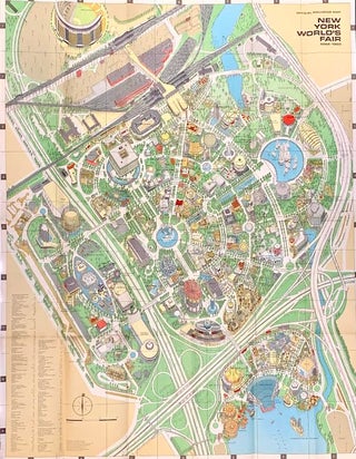
New York: Time-Life Books, 1964. Map. Colored lithograph. Image measures 32 3/8" x 25" This vibrant double-sided map was distributed for the 1964/1965 World's Fair in Queens, New York. It features a detailed pictorial map of the fair grounds, created by Hermann Bollmann for Time magazine. The map is extensively labeled with charming illustrations of the pavilions, the Unisphere, fountains, transportation centers, Shea Stadium, and more. On the verso is a map titled "The Approaches to the Fair" depicting Manhattan..... More
Maplewood: Four Oceans Press, 1990. Many black & white illustrations, diagrams, and maps. Title pages hand-colored. 3 vols in 4 books. Thick 4to, perfectly bound in printed wrappers. Maplewood: Four Oceans Press, 1990-2013. Vol I Revised (Books 1 and 2), 789 pages, limited edition of 60, (1997-2013). Inscribed by the author on fly leaf. Vol II, 448 pages, limited edition of 255, (1990). First edition. Vol III, 412 pages, limited edition of 255, (1994). First edition. All books include index..... More
Brattleboro: Stephen Greene Press, 1975. With a handful of b/w photos and transit maps throughout. 79 pages. Slim 8vo, mustard cloth, d.w. Brattleboro: Stephen Greene Press, (1975). A near fine copy with ex-libris plate to front pastedown; in a near fine dust wrapper. More
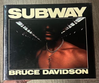
New York: Aperture, 1986. Illustrated throughout with color plates. 87 pages. Slim oblong 4to, gray silk cloth, d.w. New York: Aperture, (1986). First edition. Cloth is just a touch sunned at edges, else fine. The New York subway and its passengers provide the setting for Davidson's first extensive series in color. More
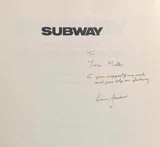
New York: Aperture, 1986. Illustrated throughout with color plates. 87 pages. Slim oblong 4to, gray silk cloth, d.w. New York: Aperture, (1986). First edition. Cloth is just a trifle sunned at bottom edge, still fine in fine dust wrapper. An excellent association copy, inscribed on the title by Davidson to an editor at Aperture: "To... For your support of my work and your help on Subway. Bruce Davidson '90." The New York subway and its passengers provide the setting for..... More
Chicago: Owen Davies, Publisher, 1963. Numerous Illus. Small folio, purple cloth, d.w. chipped and lightly soiled. Chicago: Owen Davies, Publisher, (1963). Illustrations reproduced from the Electric Railway Dictionary, published in 1911. More
Milwaukee: Kalmbach, 1975. Lightly illustrated in b/w, with several folding terminal maps. 410 pages. 8vo, navy cloth, d.w. Milwaukee: Kalmbach, 1975. A very good(+) copy in a very good dust wrapper, sunned and edgeworn. Reprint of the 1916 McGraw-Hill edition, fourth printing. More
Milwaukee: Kalmbach, 1969. Lightly illustrated in b/w, with several folding terminal maps. 410 pages. 8vo, navy cloth, d.w. Milwaukee: Kalmbach, 1969. A fine copy in a near fine dust wrapper. Reprint of the 1916 McGraw-Hill edition, third printing. More
numerous illus., some in color. 4to, cloth. London: Paul Hamlyn, (1967). History of public road transportation in Great Britain. More
London: Paul Hamlyn, 1969. Numerous Illus., some in color. 4to, red cloth, d.w. with light foxing to back panel. London: Paul Hamlyn, (1969). History of public road transportation in Great Britain. More
London: Hamlyn, 1967. Numerous illustrations, some in color. 4to, red cloth. London: Paul Hamlyn, (1967). Very good. History of public road transportation in Great Britain. More
Brick: Joseph Eid, 1980. Illus. Thin 4to, pr. wrs., wrappers with light foxing, otherwise very good. (Brick: Joseph Eid, 1980). History of New Jersey trolleys from Long Branch to Red Bank and Rumson. More
New York: Stewart Tabori & Chang, 2004. Many color illustrations throughout. 241 pages. Oblong 4to, black cloth, d.w. New York: Stewart, Tabori & Chang, (2004). First edition. Small patch of black paper pasted onto black endpaper, else a fine copy. More
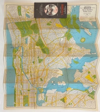
New York: Hagstrom Company, 1937. Map. Color lithograph. Pamphlet measures 8 3/4" x 4 1/4". Map measures 30 x 25 inches. Early folding map of the Bronx from 1937. The map is titled House Number and Transit Guide, and is incredibly detailed with streets, highways, subway, trolly, and bus lines, railroads, ferry routes, and more. Parks and cemeteries are colored in green, with walking paths and gardens shown. The map extends to show upper Manhattan north of 90th St., as..... More
San Francisco: Friends of the San Francisco Public Library, 1976. Illus. 8vo, pr. wrs., wrs. lightly soiled. (San Francisco): Friends of the San Francisco Public Library, (1975). More
illus. 4to, cloth. Stanford UP, (1946). vg. More
H & H Productions, 2000. Soft cover box with folded maps. H & M Productions: 2000 New York. Some toning and dings to box but maps in excellent condition. Twelve historical maps of the New York City area reprinted to their original size in a slim box. They are accompanied by a 16 page pamphlet pointing out each maps salient points. Beautifully printed. More
Urbana: University of Illinois Press, 1997. 75 Illus. 4to, blue cloth, d.w. Urbana: University of Illinois Press, (1997). Very good. More
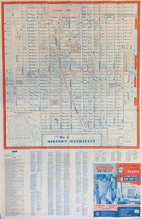
Boston: Map Corporation of America, 1964. Map. Lithograph. Unfolded pamphlet 33 1/2" x 22". Extremely detailed maps of Manhattan contained in a pamphlet entitled: "Visitor's Approved souvenir Maps of New York City." Subtitle reads: Including World's Fair Area, Manhattan, Mid-town, Subways, Financial Area. On the large map of Midtown, streets are clearly labeled as well as important buildings and institutions such as the Empire State Building, the UN, Port Authority, and Central Park. There is an index listing countless buildings..... More
Brooklyn: New York City Transit Authority, 1964. New York City transit map and station guide published in 1964 by the New York City Transit Authority. Measures 18 3/4 x 15 1/2" unfolded and 5 1/4 x 3 3/4 as pamphlet. Historical deluxe edition of the New York City subway map for the 1964 World's Fair held in Flushing Meadow Park, Queens. The subway map design includes a prominent blue arrow highlighting the special subway route that was implemented from Times..... More
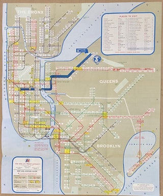
Brooklyn: New York City Transit Authority, 1974. New York City subway guide published in 1974 by the New York City Transit Authority. Designed by Massimo Vignelli. Page unfolded measures 21" x 18" and folded 7" x 3 1/2". This 1974 subway map features the iconic design made by Massimo Vignelli of the New York subway system. Prioritizing readability and aesthetics over geographical accuracy, Vignelli's design provoked immediate criticism and even ire from the public, contrasted by critical acclaim for its..... More
New York: Arno Press, 1971. Illustrated in b/w throughout. 150 pages. Slim 4to, blue cloth. New York: Arno Press, (1971). A near fine copy with light toning to endpapers; lacking dust wrapper. Facsimile of the 1904 edition. More
New York: Arno Press, 1971. Illustrated in b/w throughout. 150 pages. Slim 4to, blue cloth, edgeworn d.w. New York: Arno Press, (1971). A fine copy in a very good dust wrapper. Facsimile of the 1904 edition. More
Hello You are not going to believe this but the book was delivered YESTERDAY - we were out so they came again today. That's what I call service!!!!!!!! Thanks for the careful packing - the book is lovely. Thanks again
Congratulations on a lovely and well-deserved article in the latest New Yorker. As a modest customer of long-standing, let me add that the Argosy (including all of you) has provided me with countless hours of pleasure and pleasant discovery over the past 30+ years. My bookshelves, my mind and my life have been enriched by you all. Thank you,