
Tahiti Tattoos
Milan: Fabbri Editori, 1989. With many full-page black and white photos throughout. Unpaginated. Folio, pictorial cloth. Milan: Fabbri Editori, (1989). Text in Italian. Fine. More
Milan: Fabbri Editori, 1989. With many full-page black and white photos throughout. Unpaginated. Folio, pictorial cloth. Milan: Fabbri Editori, (1989). Text in Italian. Fine. More

London: Francis Griffiths, 1911. Numerous photographic illustrations. 197 pages + 10 pages of advertisements, foxing on endpapers. Tall 8vo, red cloth, pictorially gilt cover. London: Francis Griffiths, 1911. First Edition. A bright clean copy. Very good(+). More

London: W. Strahan and T. Cadell, 1777. Map. Uncolored engraving. London: W. Stahan and T. Cadell, 1777. Image measures 8 1/4" x 13" Nautical chart of the Friendly Islands, or present-day Tonga, in the South Pacific. Features various islands and islets, showing anchor points and topography, with depths by soundings. The tracks of the Resolution in 1773 and 1774 are delineated. In excellent condition. Captain Cook (1728 -1779) was among the most famous and important explorer, navigator, cartographer and captain..... More
Honolulu: Bishop Museum Press, 1967. Illustrated in black and white. xix, 594 pages. 8vo, decoratively gilt-stamped blue buckram (spine toned, scratched at rear). Honolulu: Bishop Museum Press, (1967). Some cracking to inner paper hinges, otherwise internally clean and tight. A very good copy. Bernice P. Bishop Museum Special Publication 56. More
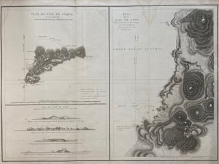
Paris: L'Imprimerie de la Republique, 1797. Map. Engraving with hand coloring. Sheet measures 21 1/4" x 28" This chart depicts Easter Island, with a close-up of Cook's Bay. Relief is depicted by hachure, and elevation is shown from several vantage points. Points and peaks of the elevation views correspond to labels on the map. The Bay shows depths, and various structures are labeled. The map appeared as Plate 10 in "Atlas du Voyage de La Perouse." It is in very..... More
Cologne: Konemann, 1995. Hundreds of color photographs by Olaf Wipperfurth. 2 volumes, tall 4to, black cloth, d.w., pictorial board slipcase. Koln: Konemann, (1995). A fine set. Text in English, German and French. More
Boston: Little Brown, 1962. 8vo, blue cloth, lightly soiled d.w. Boston: Little Brown, (1962). Memoir of the South Seas. More
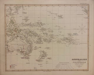
Gotha: Justus Perthes, 1850. Map. Engraving with hand outline coloring. Image measures 12" x 15" Incredibly detailed map in German of the Pacific Ocean, including Australia, Southeast Asia, and New Zealand. Island groups are extensively labeled, and hand coloring is used throughout to indicate colonial holdings. This map appeared in the 1853 issue of Stieler's Hand Atlas. In very good condition with minor spotting, and toning to margins - not affecting the image. The publishing firm of Justus Perthes (1749-1816)..... More
Cleveland: World, 1963. 8vo, green cloth, chipped and lightly soiled d.w. Cleveland: World, (1963). Presentation copy. More

Ithaca: Cornell University Press, 2019. 8vo, blue boards, d.w. Ithaca: Cornell University Press, (2019). First Edition. Fine. Warmly inscribed,"Bill" by the author on the title page. More
New York: Augustin, 1948. Photographs and other illustrations. 4to, black cloth, edgeworn d.w.. New York: J.J. Augustin, (1948). First Edition. Very good in very good(-) dust wrapper. More
I have received the book here in Egypt in excellent shape. I wish to express my extreme satisfaction for the excellent service you offered me. Thanks again!
Thank YOU sir! My Dad really wanted this book! My folks just bought a place in Spain, and I looked all over for this book! I'm so glad that I found it, can't wait to see his face on Christmas! Being that it's so old, he never thought he'd get one. Again, thank you!