
Burmese History Before 1287: A Defence of the Chronicles.
Oxford: Asoka Society, 1970. 46 pages. Tall slim 8vo, stiff yellow printed wrappers; some spotting on spine. Oxford: Asoka Society, 1970. First Edition. Very good(+). More

Oxford: Asoka Society, 1970. 46 pages. Tall slim 8vo, stiff yellow printed wrappers; some spotting on spine. Oxford: Asoka Society, 1970. First Edition. Very good(+). More

New York: Macmillan, 1980. Illustrated with b/w photographs. 304 pages. 8vo, black cloth backed red boards, d.w. (small tears to top edge of front panel). New York: Macmillan, (1980). First American edition. A fine copy in a very good(+) dust wrapper. More
Cambridge: Harvard University Press, 1976. 5 maps. 8vo, two-toned cloth, d.w. rubbed. Cambridge: Harvard University Press, 1976. Very good. More
Berkeley: University of California Press, 1942. Map. ix + 381pp., 8vo, cloth, d.w.; dust wrapper tattered. Berkeley: University of California Press, 1942. A very good copy. More
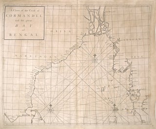
London: James and John Knapton, 1728. Sea Chart. Uncolored engraving.19 x 22 1/2 inches. This beautiful early sea chart of the Coromandel coast in Southeast India covers the entire eastern coast of India as well as the western coast of Burma (Myanmar) and southern Thailand. Extends from modern day Kanyakumari north to include the Ganges River Delta, the coast of Bangladesh and then south along western coast of Burma or Myanmar to Thailand. The northern parts of Sri Lanka or..... More
Garden City: Doubleday, 1946. Illustrated. 320 pages. 8vo, dark green cloth, pictorial d.w. (edgeworn). Garden City: Doubleday, 1946. First edition. Near fine in very good(+) dust wrapper. More

London: Cassell, 1964. Illustrated with b/w photographs. xiii + 231 pages. 8vo, green cloth, d.w. (wear and toning, faint soiling to verso; price-clipped). London: Cassell, (1964). First edition. Slight lean to spine, tiny spots of foxing to some leaves. A very good(+) copy in a very good(+) dust wrapper. More
London: Merrell, 2000. Edited by Elizabeth Dell. 250 photographs selected from The James Henry Green Collection. 192 pages, 4to, brown boards, d.w. London: Merrell, in association with The Green Centre for Non-Western Arts, (2000). A very good(+) copy in a very good(+) dust wrapper. More
London: Longmans, 1925. With a preface by Richard Carnac Temple. 7 illustrations and 5 colored maps. 415 pages. Thick 8vo, gilt-lettered blue cloth (small library stamp inside cover, otherwise clean). London: Longmans Green, 1925. First A very good(+) copy. More
Baltimore: Galahad Press, 1999. Illus. 772pp. 8vo, pr. wrs. Baltimore: Galahad Press, (1999). Near Fine. More
New York: Random House, 1981. Black & white photographic illustrations. 302 pages. 8vo, blue cloth with gilt lettering, pictorial d.w. New York: Random House, (1981). First Edition. Some pages lightly toned. A near fine copy in a near fine dust wrapper. More
AMS, 1972. 8vo, turquoise cloth in original shrinkwrap. AMS, 1972. A fine copy. More
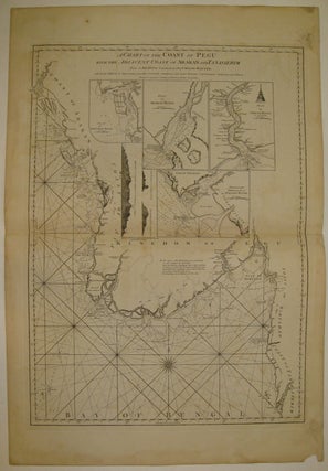
London: Laurie & Whittle, 1799. Sea chart. Uncolored copper plate engraving. Image measures 30 5/8" x 22". Magnificent and intricate sea chart showing the coast of the Burman Peninsula from the Bay of Bengal to the Gulf of Martaban. Details include rhumb lines, depths, and a compass rose. Dotted lines indicate rivers whose paths are not definitively known. Four insets show close ups of the Martaban River, the Arakan River, the Sirian River and the entrance of the Perseen River..... More
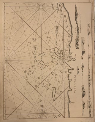
London: Laurie & Whittle, 1761. Sea chart. Uncolored copper plate engraving. Image measures 18 1/4 x 24 1/2 inches. The Tenasserim Hills are part of a long granite mountain ridge that is older than the Himalayas. The Burmese range form a barrier between the Andaman sea and the Gulf of Thailand. Elevations shown in side profile, oriented to the left. Tiny islands and reefs described in detail but not named.Published in "The East-India Pilot, or Oriental Navigator, on One Hundred..... More
New York: Farrar, Straus & Giroux, 2006. Black & white photo illustrations. 361pp. 8vo, yellow boards, d.w. New York: Farrar, Straus & Giroux, (2006). First Edition. Near fine in a near fine dust wrapper. More

New York: Farrar, Straus & Giroux, 2006. Illustrated. 361 pages, 8vo, yellow boards, d.w. New York: Farrar, Straus & Giroux, (2006). First Edition. A fine copy in a fine dust wrapper. More
Vienna: 1956. Color & b/w illustrations. 150pp., 4to, cloth, dust wrapper; small tear on d.w. spine, cardboard slipcase. Wien, (1956). Very good. More
New York: Harcourt, 1967. Illustrated. xi + 237 pages, 8vo, black cloth, d.w. New York: Harcourt, Brace & World, (1967). First edition. A very good(+) copy in a very good dust wrapper. More
London: Fisher Unwin, 1925. Black and white illustrations. 372 pages, thick tall 8vo, red cloth. London: Fisher Unwin, 1925. Second Edition. Fine. More
New York: Norton, 1946. Frontispiece, illustrations and maps by Phoa Lieng Sing and Lucas Manditch. 268pp., 8vo, beige cloth, stained, page edges foxed. New York: W.W. Norton, (1946). First Edition. A good copy. More
Philadelphia: Judson, 1930. Illustrated with b/w photos. 174 pages. Short 8vo, red cloth. Philadelphia: Judson, (1930). First edition. A good only copy--foxing to pages, frontis detached, sunned spine, soiling to cloth, previous owner signature on endpaper. More
1965. illus. 8vo, cloth, d.w. Bloomington: Indiana UP, (1965). More

1964. Signed black and white photograph of Adlai Stevenson, United States ambassador to the United Nations center. Flanked by Burmese diplomat and the third secretary-general of the United Nations, U Thant. On the other side, Francis Taylor Pearsons Plimpton, deputy US ambassador to the UN. Inscription reads "For Susan Schiff - with admiration for a fine photographer - Adlai E. Stevenson 1964". Photograph from photojournalist Susan Schiff-Faludi's personal collection. Please inquire for more information. Adlai Ewing Stevenson II was an..... More
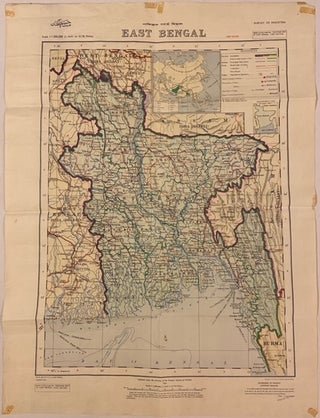
Murree: Surveyor General of Pakistan, 1954. Map. Color lithograph. First edition. Sheet measures 26" x 34 1/4" This map of East Bengal, known as present-day Bangladesh, was published by the Government of Pakistan in 1954. The province of East Bengal existed from 1947 to 1955, when it was dissolved and renamed as "East Pakistan". This map provides fascinating insight into this brief historical period of the region. Shows roads, railways, cities, towns, and villages, as well as places of archeological..... More
This morning in Arnhem I did receive the book in fine condition. Thank you for your careful sending!
Received the book today and I thank you for such prompt service, I'm delighted and I know my mother-in-law will be particularly pleased.