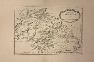
Carte de L'Indoustan 1e. Feuille
Paris: Bellin, 1764. Map. Engraving with hand coloring. Image measures 8 3/4" x 12 1/4" This map of the northern India depicts the region from present-day Pakistan to the Gulf of Bengal, extending north to Kabul, and centered on the city of Delhi. A lovely Baroque title cartouche adorns the map. Mountains are rendered pictorially, and cities, towns, islands, and coastal features are labeled. From "Le Petit Atlas Maritime", published in 1764. In excellent condition, with wide margins as issued..... More