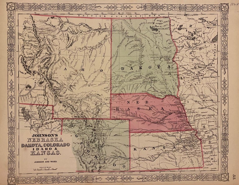
Johnson's Nebraska, Dakota, Colorado, Idaho, & Kansas
Philadelphia: Johnson and Ward, 1864.
Map. Steel engraving with original hand coloring. Image measures 12 3/4" x 15 1/2".
Classic 1864 map of the west, with Kansas, Nebraska, Dakota, Idaho, and parts of Colorado. Counties, major towns and cities, routes, railroads, and waterways are labeled. Notations describing indigenous populations are included throughout. This is the first map to depict the Idaho Territory, which was officially organized in 1863. It covers a much larger region than the state of Idaho, encompassing almost all of present-day Wyoming and part of Montana, which was organized as its own territory in 1864. The map also features various routes explored for the proposed Pacific Railroad. A fascinating snapshot of western expansion during a time of rapid change. Two closed tears to lower margin. Minor chips at edges.
Alvin Jewett Johnson (1827-1884) was one of the most prolific American publishers of the 19th century. He opened his own company in 1856 that produced atlases, maps and encyclopedias, working over the following decades with Benjamin Ward and later his son in the business of publishing and updating the legacies of advanced American cartography. This map demonstrates his commitment to the advancement of both cartographic knowledge and beautiful design.
Binding: Unbound
Language: English
Price: $225.00
Item #310079