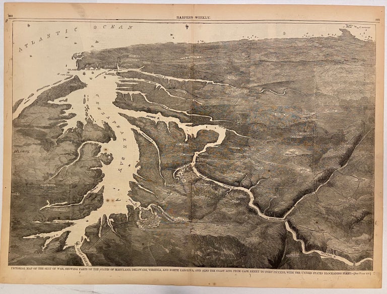
Pictorial Map of the Seat of War, Showing Parts of the States of Maryland, Delaware, Virginia, and North Carolina, and also the Coast Line From Cape Henry to Fort Pickens, with the United States Blockading Fleet
Harper & Brothers, 1861.
View. Uncolored Wood engraving. Image measures 13 7/8" x 20 3/8".
This double-page bird's eye view of the Chesapeake Bay region was published at the start of the Civil War. Looking southward from Maryland, the view extends along the Atlantic coast, showing the Florida panhandle in the distance. Cities are depicted pictorially, and ships are illustrated outside each major coastal city. A description on page 359 reads "We publish a large Birds-Eye View of the Seat of War in Virginia and the neighborhood, which will enable our readers to follow the march of the armies intelligently." The text includes notes on prominent locations included in the map. For example, "Fredericksburg enjoys good natural facilities for military defense, from its contiguity to the Potomac, and is now being used as the concentrating point for a large body of rebel troops." Rivers, railroads, towns, and cities are labeled. Published as a supplement to the June 8, 1861 issue of Harper's Weekly.
Harper's Weekly was a New York-based illustrated political magazine published from 1857 until 1916. The magazine featured foreign and domestic news, fiction, essays on many subjects, and humor. Its most well-known contributor was Thomas Nast, who made his career doing political cartoons for the publication.
Binding: Unbound
Language: English
Price: $165.00
Item #299997