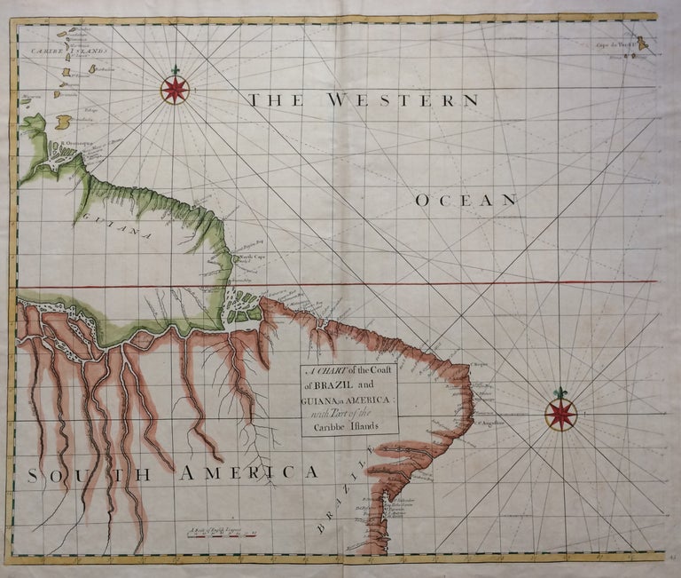
A Chart of the Coast of Brazil and Guiana in America: with Part of the Caribbe Islands
James and John Knapton, 1728.
Sea Chart. Colored engraving. Sheet measures 21 1/4" x 25". Image measures 19 1/2" x 23 1/2".
This stunning map of the western hemisphere depicts Guiana and Brazil in South America presented on Edward Wright's projection, also called a globular projection. It features rhumb lines to facilitate navigation. The map focuses more on the coastlines rather than the interiors.
This chart was made for the 1728 issued of "Atlas maritimus & commercialis, or, A general view of the world, so far as relates to trade and navigation". The atlas which was meant to compete with Mount and Page's popular "English Pilot", was a collaboration between some of the leading cartographers of the time, including Sir Edmund Halley, John Senex, Nathaniel Cutler, Steven Parker and Daniel Defoe. The atlas unfortunately failed to achieve commercial success as great as its rival, making this a hard-to-find map.
The map is in good condition with minor wear along the original folds and overall toning. Some toning over joint. Original plate mark is visible.
John Senex (1678-1740) was a kind of Renaissance man of the 18th-century map world, working at times as a scholar, surveyor, engraver, astrologer, book seller and publisher of maps, atlases and globes. In a short period, he developed from an apprentice into one of the most important cartographers of the period and became a Fellow of the Royal Society of London, as well as Official Geographer to Queen Anne of Great Britain. Although well regarded for his pocket-size maps, Senex is probably best known for his globes, which display a knowledge of astronomy equal to the skill of their craftsmanship. After his death in 1740 his wife Mary continued his business and continued to produce and sell cartographic works of high quality. Together, their work represents a successful and valuable partnership in 18th-century mapmaking and publishing.
Sir Edmond Halley (1656--1742) was an English astronomer, geophysicist, mathematician, meteorologist, and physicist known for computing the orbit of the eponymous Halley's Comet. He was the second Astronomer Royal in Britain after John Flamsteed. Globular Projection maps were invented by Halley, Harris and Senex. This is a wonderful example of their collaborative work.
Binding: Unbound
Edition: First
Language: English
Price: $500.00
Item #279748