
A Newe Mape of Tartary; 1626 John Speed Map of Tartary
London: George Humble, 1626.
Map. Engraving with hand coloring. Image measures 15.25" x 19.75".
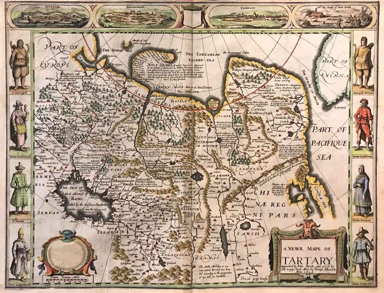
This beautiful carte a figures map of Tartary by John Speed presents the many geography speculations found at a time when parts of Asia were largely unexplored by Europeans. Extends from Armenia eastward to include part of North America and includes the Arctic Sea and Nova Zembla.
Korea is presented as an Island while the Kamchatka Peninsula is entirely absent. The Straits of Anian, believed to be associated with the mythical Northwest Passage is identified. The Great Wall of China is depicted in a grand style, south of which lies the Kingdom of China. Throughout, several kingdoms, important cities, rivers, lakes, islands, mountains, and other topographical features are noted. These includes important cities which were part of the ancient Silk Route.
The Caspian Sea, presented along its East-West Axis according to the practice of the time, is identified by various names (Sea of Sala otherwise Bachu, called by the Russians Chualenske More, in old time the Caspian and Hircan Sea). Further north Tazota Island, from the Roman geographer Pliny the Elder, appears in the Arctic Circle.
Beijing or Peking appears north of the Great Wall and is identified by the name Cambalu, as used my Marco Polo. Interesting notations are also included throughout, including one north of the Great Wall reading, "In this Country is a hil out of which they dig earth called by Pliny terra Asbestus, having fine veines like grasse which being spun and weaved yeeld cloth that wil nut burn in the fire".
The map is surrounded on the left and right with illustrations of the costumes and people from various parts of the region. Along the top border, four views are included detailing the cities Astrakan, Samarkand, Cambalu, and a view of the house of Nova Zembla.
Engraved by Dirck Grijp. Appears in Speed's important "Prospect of the Most Famous Parts of the World". The map is in good condition with some wear along the original centerfold. Overall foxing and some tape residue long the top margin from framing. Very good impression. English text verso.
John Speed (1552-1629) is widely considered to be the most famous English cartographer of the 17th century. His atlas "The Theatre of the Empire of Great Britaine" contained the first set of individual county maps of England and Wales, as well as significant town plans that are in many cases the first visual records of their subjects. This important map of Asia is a wonderful example of his work.
Binding: Unbound
Language: English
Price: $3,000.00
Item #273459