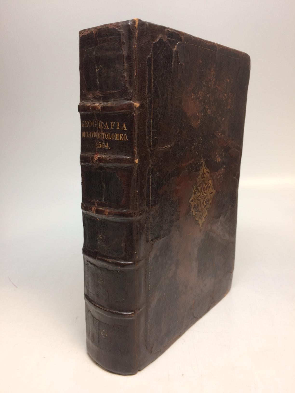
La Geografia di Claudio Tolomeo Alessandrino, Nuouamente tradotta di Greco in Italiano, da Ieronimo Ruscelli; Con Espositioni del medesimo, particolari di luogo in luogo, & uniuersali sopra tutta il libro, & sopra tutta la Geografia, o modo di far la descrittione di tutto il mundo...
Venice: Giordano Ziletti, 1564.
3 parts in 1. Each part has a separate title page with large printer's device. Part 2: Espositioni et Introduttioni Universali di Girolamo Ruscelli, sopra tutta la Geografia di Tolomeo. Part 3: Discorso Universale di M. Gioseppe Moleto mathematico. Illustrated with 63 (of 64) fine double-leaf copper engraved maps, including the rare "World in Hemispheres". Additional large in-text engravings and decorative initials throughout. [8], 358, [110], [204], [48] index, 47 pages. Short thick 4to, bound in old calf with gilt devices on covers, neatly re-cased (binding well-rubbed but very sound; very clean copy, virtually free of foxing; one map ink stained; lacks the final world map "Carta Marina"), a.e.g. Venetia: Appresso Giordano Ziletti, 1564. Text in Italian. Bookplate of Otto Orren Fisher pasted on inside cover. Manuscript note in ink on title page reads: Ex Libris Stephan Tiapas.
Second edition of Ruscelli's Italian translation, very similar to the edition of 1561, and containing the same series of maps. The double- page maps are partly based on those of Jacopo Gastaldi in the edition of 1548, but on a larger scale. According to Nordenskiold, two important innovations were introduced (by the 1561 edition) into cartographical literature. One: the division of the Map of the World in two hemispheres. Two: The re-issue of the Zeno Map of the Arctic Regions, which had appeared first 3 years before. "If the remarkable map in this little work had not received extensive circulation, under the sanction of Ptolemy's name, it would probably have been forgotten. During nearly a whole century it exercised an influence on the mapping of the northern countries, to which there are few parallels in the history of cartography".
Girolamo Ruscelli (c. 1504-1566) was a Venetian editor, whose maps are primarily based on those by Jacopo Gastaldi (1548) but with many of his own additions and reproduced on a larger scale. Ruscelli introduces several important innovations in this volume through his 37 "modern" maps, which cover Europe, Africa, Asia and the New World. Ruscelli includes a double hemisphere world map, which was the first of its kind to be used in an atlas, and "Carta Marina Nuova Tavola", a rare sea chart of the world. He includes a revised version of the Zeno map of the Arctic, first published in 1558. The Zeno map describes the purported journey of the author's ancestors in the 1390s to Greenland, Iceland, the mythical islands of Frisland and Icaria, and what is now thought to be Newfoundland and Labrador. While Zeno shows Greenland connected to Norway, Ruscelli has updated the map by eliminating this land bridge. Despite its inaccuracies and inclusion of mythical lands, the Zeno map persisted as the prevailing map of the Arctic and Greenland for many years. Six other New World maps include the South American continent, Brazil, Central America and the Baja Peninsula, the eastern coast of North America, Cuba and Hispaniola. Claudius Ptolemy (90-168 CE) was a Roman geographer and mathematician living in Egypt, who compiled his knowledge and theories about the world's geography into one seminal work. Although his maps did not survive, his mathematical projections and location coordinates did. During the Renaissance revival of Greek and Roman works, "Geographia" was rediscovered by monks and based upon Ptolemy's detailed instructions, the maps were recreated. The first printed edition of "Geographia" with maps was published in Bologna in 1477. A rare and exciting edition for any collector. Sabin 66504
Binding: Hardcover
Condition: Very Good(+)
Language: Italian
Price: $11,000.00
Item #265015