

Vol. 8 of 29 Atlases of Insurance Maps for Brooklyn. East New York
New York: Sanborn Map Company, 1928.
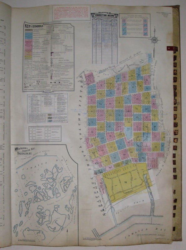
Atlas. Lithograph with original hand coloring. Massive elephant folio. Decorative calligraphic titles, indices, and key maps. Contains a set of 76 detailed maps of East New York along with changes recorded on paste-on correction slips through 1973. Quarter leather binding with gilt title on front and spine. Original protective canvas cover in very good condition.
This volume includes an inset "Map of Islands of Jamaica Bay, Brooklyn, NY", Sunrise Highway and Conduit Avenue Extension. The Sanborn map collection consists of a uniform series of large scale maps, dating from 1867 to the present depicting the commercial, industrial, and residential sections of some twelve thousand cities and towns in the United States, Canada, and Mexico. The maps were designed to assist fire insurance agents in determining the degree of hazard associated with a particular property and therefore show the size, shape and construction of dwellings, commercial buildings, and factories as well as fire walls locations of windows and doors, sprinkler systems, and types of roofs. The maps also indicate widths and names of streets, property boundaries, building use, and house and block numbers. They show locations of water mains, giving their dimensions, and of fire alarm boxes and hydrants. Sanborn maps are an unrivaled source of information about the structure and use of buildings in American Cities. The collection includes some fifty thousand editions of fire insurance maps comprising an estimated seven hundred thousand individual sheets. The Library of Congress holdings represent the largest extant collection of maps produced by the Sanborn Map Company. The majority of the maps were acquired by the Library through copyright deposit, but the collection was substantially enriched in 1967 when the Bureau of the Census transferred to the Library of Congress a complete set. The 1,899 loose-leaf binders were particularly noteworthy because they included later editions than those previously acquired by the Library. The Bureau of the Census set of maps had been regularly updated by printed, paste-on corrections supplied by the Sanborn Map Company, whereas the Library of Congress copies were retained in the form in which they were copyrighted.
Binding: Hardcover
Condition: Very Good
Language: English
Price: $650.00
Item #214841