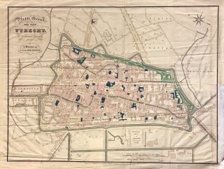
Platte Grond der Stad Utrecht
Utrecht: Nicolaas van der Monde, 1838. Map. Engraving with original hand color. Image measures 14.5" x 19.75". This 1836 Dutch map by Nicolaas van der Monde depicts the city of Utrecht in the Netherlands. Beautifully detailed, the map notes individual streets, buildings, waterways, and other topographical features. The map was engraved by W C van Baarsel and Petrus Nicolai Tuyn. In average condition with verso repairs and reinforcements along the margins. Creases along folds. Lower right margin extended. Edge wear..... More