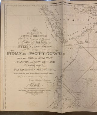
To The Honourable the Court of Directors of the United Company of Merchants Trading to the East Indies, Steel's New Chart of the Indian and Pacific Oceans;; from the Cape of Good Hope to Canton and New Zeeland: Including all the Passage to India and China.
London: J.W. Norie, 1822. Map. Uncolored engraving. 22 x 76 1/4 inches. (one of two sheets). This large 1822 map is the top half of Steel's sea chart of the Indian Ocean and Pacific Ocean. Even though this map is only the top portion, it includes most of the land areas depicted on the full map--North and East Africa, Arabia, India, Southeast Asia, the East Indies, Singapore, and the Philippines--and is absent only the southern part of Africa and Australia..... More