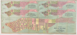
Map of the City of New York, Showing Its Political Divisions and Subdivisions November 1870
New York: John Hardy, 1870. Color lithograph. 17.5" x 39.5". Expertly repaired on verso. In very good condition. This is a large 1870 map of New York City issues by John Hardy. Actually five maps on one sheet, each map depicts a different aspect of the political landscape of the city. The large map at the bottom shows Ward Boundaries, Assembly Districts, and Election Districts. Four smaller maps on top are divided into Wards and Senate Districts, Wards and Congressional..... More
