
The Sinclairs of Old Fort Des Moines; A Historical Romance.
12mo, cloth, d.w. Cedar Rapids: Torch, 1927. More
12mo, cloth, d.w. Cedar Rapids: Torch, 1927. More
New York: Valentin, 1944. A collection of 83 classic nursery rhymes, along with 85 whimsical drawings by Alexander Calder. xxii, 130, [6] pages. Short folio, burgundy cloth-backed pictorial boards, uncut edges. New York: Curt Valentin, 1944. Limited first edition, signed. Printed by S. A. Jacobs at the Golden Eagle Press. From a total of 700 copies this is number 15 of only 60 copies on Sevir mould paper, signed and numbered by Calder. Lacks the original drawing, as usual. Unfortunately..... More
Illus. 383pp. 8vo, cloth. London, (1951). More
Conshohocken: Combined Publishing, 1999. Illus. 8vo, pr. wrs. (Conshohocken): Combined Publishing, (1999). Fine. More
Philadelphia: The University of the Arts, 1995. An unusual artist's book -- colorful illustrated pages folded accordion-style with die-cut pages to reveal, when extended, a peep through of a circus scene depicting the title action. Philadelphia: The University of the Arts, 1995. Limited first edition -- number 8 of only 20 copies, signed by Engelbart. Scarce. More
New York: Abbeville, 1991. Illustrated throughout in color. 240pp. Square 4to, green cloth, d.w. (large closed tear on rear panel). New York: Abbeville Press, (1991). First edition. A fine copy in a very good dust wrapper. More
New York: Scribner, 2005. 356 pages. 8vo, brown cloth-backed white boards with gilt lettering at spine, pictorial d.w. New York: Scribner, (2005). Pages toned, otherwise a fine copy in a fine dust wrapper. More

New York: Johnson & Browning, 1859. Map. Engraving with original hand coloring. Image measures 13" x 15 7/8". Classic map of Iowa divided into counties. Shows towns, major routes, railroads and waterways. A few closed tears tears to edges, not affecting the image. Alvin Jewett Johnson (1827-1884) is one of the most prolific American publishers of the 19th century. He opened his own company in 1856 that produced atlases, maps and encyclopedias. The company made great maps based on those..... More

New York: Johnson & Browning, 1861. Map. Engraving with original hand coloring. Image measures 12" x 16.75". Nice map of Iowa and part of Nebraska, divided into counties. Shows towns, major routes, railroads and waterways. A few scattered chips and tears to edges, image unaffected. Alvin Jewett Johnson (1827-1884) is one of the most prolific American publishers of the 19th century. He opened his own company in 1856 that produced atlases, maps and encyclopedias. The company made great maps based..... More
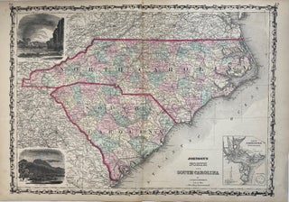
New York: Johnson and Browning, 1862. Map. Engraving with original hand coloring. Image measures 17.5" x 24". Beautiful double page map of North and South Carolina. Delineates counties, towns, major routes, waterways and railroads. Includes an inset of Charleston Harbor and views of "Chimney Rocks & French Broad River" and "Table Mountain". Minor toning and wear to original fold lines. Alvin Jewett Johnson (1827-1884) is one of the most prolific American publishers of the 19th century. He opened his own..... More
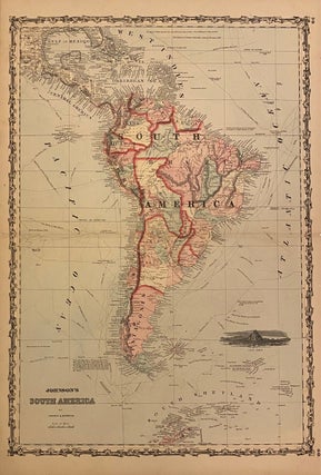
New York: Johnson & Browning, 1861. Map. Engraving with original hand coloring. Image measures 24 1/2" x 17". New York: 1861. Beautiful map of the continent extending from Gulf of Mexico to the South Shetland Islands. Includes black and white view of Cape Horn and paths and dates of historical explorations. Some splitting along centerfold, reinforced with archival tape. Otherwise in very good condition. A dark, crisp impression with vibrant hand-colored outlines. Alvin Jewett Johnson (1827-1884) is one of the..... More

New York: 1856. Map. Lithograph with full original coloring. 12 3/4 x 15 1/2 inches. Beautiful map of Canada with viviid color shown as a British Colony. Forts, rivers, mountains and towns are noted throughout. Alaska is shown as 'Russian Possessions'. In good condition with some light toning and small chips to margins. Alvin Jewett Johnson (1827-1884) is one of the most prolific American publishers of the 19th century. He opened his own company in 1856 that produced atlases, maps..... More
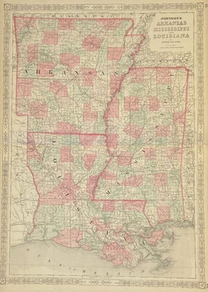
New York: Johnson & Ward, 1863. Map. Steel engraving with original hand coloring. Image measures 24.25" x 17.25". Classic map of Arkansas, Mississippi and Louisiana divided into counties and townships. Shows all major towns, cities, routes, waterways and railroads. Alvin Jewett Johnson (1827-1884) is one of the most prolific American publishers of the 19th century. He opened his own company in 1856 that produced atlases, maps and encyclopedias. The company made great maps based on those by J.H. Colton and..... More
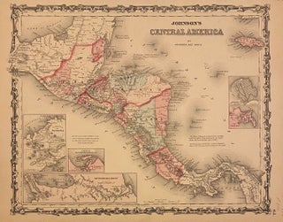
New York: Johnson & Ward, 1863. Map. Engraving with original hand coloring. Image measures 12 1/2" x 15 1/2" Clear and detailed map of Central America published in 1863. An ornate decorative border surrounds the map. Includes views of The Isthmus of Panama, The Nicaragua Route, and the harbor of San Juan de Nicaragua, as well as grid plans of the City of Panama, and Aspinwall City on the island of Manzanilla. In very good condition. Archival tape repair to..... More
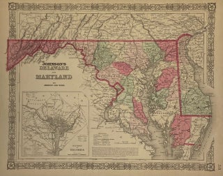
New York: Johnson & Ward, 1864. Map. Engraving with original hand coloring. Image measures 12.75" x 15.75". Nicely detailed map of Delaware and Maryland showing counties, towns, waterways and railroads. Includes a black and white inset of the District of Columbia. A few small chips and tears to left edge. Alvin Jewett Johnson (1827-1884) is one of the most prolific American publishers of the 19th century. He opened his own company in 1856 that produced atlases, maps and encyclopedias. The..... More

New York: Johnson & Ward, 1864. Map. Engraving with original hand coloring. Image measures 13 1/2" x 18 1/8". Nice city plan of Washington D.C. Shows wards, streets, parks, notable buildings and institutions, railroads and waterways. Includes images of the capitol building, the Washington Monument and the Smithsonian Institution. In good condition. Alvin Jewett Johnson (1827-1884) is one of the most prolific American publishers of the 19th century. He opened his own company in 1856 that produced atlases, maps and..... More

New York: Johnson & Ward, 1866. Map. Engraving with original hand coloring. Image measures 13 1/2" x 18 1/8". Fine city plan of Washington D.C. Shows wards, streets, parks, notable buildings and institutions, railroads and waterways. Includes images of the capitol building, the Washington Monument and the Smithsonian Institution and the signature 4 star border. In this 1866 edition, Arlington Heights is noted as well as Uniontown. Alvin Jewett Johnson (1827-1884) is one of the most prolific American publishers of..... More
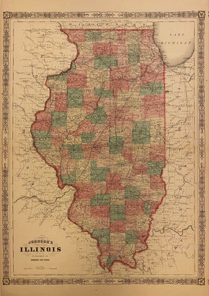
New York: Johnson & Ward, 1865. Map. Engraving with original hand coloring. Image measures 23.25" x 17.25". Nicely detailed map of Illinois divided into counties showing towns, waterways and railroads. Minor scattered foxing. Alvin Jewett Johnson (1827-1884) is one of the most prolific American publishers of the 19th century. He opened his own company in 1856 that produced atlases, maps and encyclopedias. The company made great maps based on those by J.H. Colton and Johnson produced a newly updated version..... More
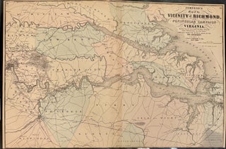
New York: Johnson & Ward, 1865. Map. Engraving with original hand coloring. Image measures 17.75" x 26.5". This map of Richmond and the surrounding era is hand-colored by counties. Compiled from the official maps of the War Department in 1864, it includes information about the peninsular campaign in Virginia, showing the line of advance and retreat of the Union Army, several battles and other details. As a subtitle notes, the map also shows "the interesting localities along the James, Chickahominy..... More
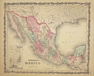
New York: Johnson and Ward, 1863. Map. Engraving with original hand coloring. Image measures 12.5" x 15". This beautiful 1863 map was issued by Johnson and Ward. The map includes Texas, Guatemala and other nearby regions. It features an inset featuring the Territory and Isthmus of Tehuantepec, the site of a proposed trans-continental canal similar to the Panama Canal. The canal was never built. Several cities, towns, canals, and topographic details are noted throughout the map, including "uninhabited" deserts with..... More

New York: Johnson & Ward, 1864. Map. Engraving with original hand coloring. Image measures 17.75" x 24". Beautifully detailed double page map of Wisconsin and Michigan divided into counties and townships. Shows cities, major routes, railroads and waterways. Alvin Jewett Johnson (1827-1884) is one of the most prolific American publishers of the 19th century. He opened his own company in 1856 that produced atlases, maps and encyclopedias. The company made great maps based on those by J.H. Colton and Johnson..... More
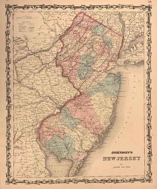
New York: Johnson & Ward, 1862. Map. Engraving with original hand coloring. Image measures 15.25" x 12.5". Greatly detailed map of New Jersey, enclosed by an ornate boarder. Counties are delineated by color. Eastern Pennsylvania and Delaware are visible, as well as New York City. Small chip on lower right hand corner, does not affect image. Alvin Jewett Johnson (1827-1884) is one of the most prolific American publishers of the 19th century. He opened his own company in 1856 that..... More
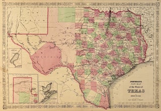
New York: Johnson & Ward, 1864. Map. Engraving with original hand coloring. Image measures 16 1/2" x 24 3/8" Beautifully detailed double page map of Texas divided into counties, with the northern part of the state in an inset. Shows towns, waterways, major routes, railroads and topographical details. Includes uncolored inset maps of Galveston Bay and Sabine Lake. In very good condition, with minor chips and several closed tears and repairs to edges. Minimal scattered spots. Lovely fretwork border with..... More
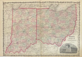
New York: Johnson & Browning, 1862. Map. Engraving with original hand coloring. Image measures 17" x 24". Beautifully detailed double page map of Ohio and Indiana divided into counties and townships. Shows towns, major routes, waterways and railroads. Includes image of the state capitol building in Columbus. In excellent condition. Alvin Jewett Johnson (1827-1884) is one of the most prolific American publishers of the 19th century. He opened his own company in 1856 that produced atlases, maps and encyclopedias. The..... More
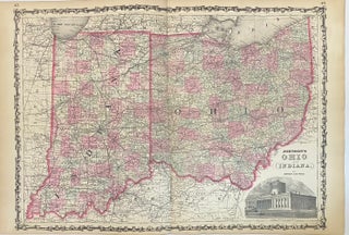
New York: Johnson & Ward, 1863. Map. Engraving with original hand coloring. Image measures 17" x 24". Beautifully detailed double page map of Ohio and Indiana divided into counties and townships. Shows towns, major routes, waterways and railroads. Includes image of the state capitol building in Columbus. In excellent condition. Alvin Jewett Johnson (1827-1884) is one of the most prolific American publishers of the 19th century. He opened his own company in 1856 that produced atlases, maps and encyclopedias. The..... More
Hello. The Richard Lower (Tractatus de Corde) has arrived and it is a nice copy. Thanks for getting the minor restorations done and sending this so promptly.
I usually receive my packages as soon as delivered. However, this one had quite a night outside in a snow storm. Thanks to the extra care in packaging and double layer of wrapping cardboard and plastic bag, the book survived in pristine condition.... It sat in a three foot snow drift pounded by snow plows, in minus 25Temps overnight and was discovered this afternoon, the top of the package peeking out of the drift. If not for the attention to packaging and packing materials, this book would have been destroyed. Please let the people who package our treasures know that they make a difference. Whether in person or mail order, you folks rock. Best wishes from the (damned) frozen Adirondacks...