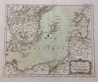
Carte de la Mer Baltique
Bellin, 1764. Map. Engraving with original hand coloring. Image measures 8.75 x 10.75 inches. Page measures 13 x 14.25 inches. I Beautiful map of the south Baltic Sea including part of Southern Sweden, Poland, Lithuania, Latvia and Estonia. Jacques Nicolas Bellin (1703-1772) was the official hydrographer to the French king and the first person to hold the title of "Ingénieur de la Marine of the Depot des cartes et plans de la Marine" (chief engineer of the French Hydrographical Office)..... More