
Afrique (Cote Nord) A L'est Du Detroit De Gilbraltar Levant Entre La Mer Egee Et Le Canal De Suez.
Paris: 1968. One folding map. 8vo, cloth. Paris: Imprimerie Nationale, 1968. More
Paris: 1968. One folding map. 8vo, cloth. Paris: Imprimerie Nationale, 1968. More
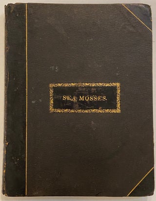
8vo in 3/4 dark brown leather, spine rubbed with laid title on front cover. 40pp with 35 actual specimens carefully preserved on white cards tipped in to each page. p18 has small tape repair otherwise in very good condition. London circa 1890. Exquisite 19th century scrapbook of artfully arranged seaweed specimens. Seaweed collecting was, a sub category of scrapbooking, and a popular activity for women during the Victorian era. It was considered a wholesome way for women to engage with..... More
London: Macmillan, 1964. Illustrated throughout. Tall 8vo, cloth. London: Macmillan, 1964. A Chief Chemist's memoir of 20 years whaling in the Antarctic Ocean. More
New York: Walker, 1982. Illustrated by David Wool. 64p. blue boards, d.w. New York: Walker & Co., (1982). First Edition. More
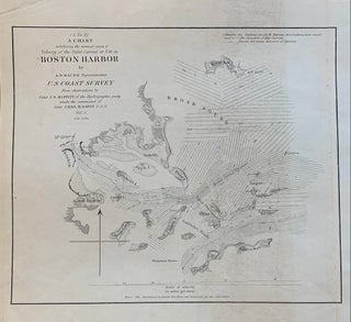
Washington: Government Printing Office, 1851. Sea chart. Uncolored engraving. Image measures 7.5 x 9 inches. This fantastically detailed sea chart issued by the United States Coast Survey in 1851 beautifully depicts the Boston Harbor and tidal currents. It extends as far north as Nahant, as far south as Petticks Island, to Hull, and as far west as Boston.The map is in good condition, with minor toning. Alexander Dallas Bache (1806-1867) was an incredibly prolific surveyor, who worked as the superintendent..... More
New York: Basic Books, 1957. Illustrated. 325pp., 8vo, cloth, d.w. New York: Basic Books, (1957). Very good. More
436pp., illus. in b/w. Thick 8vo, cloth, d.w. Boston: Little Brown, (1969). Very good. More
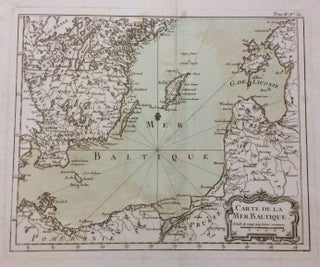
Bellin, 1764. Map. Engraving with original hand coloring. Image measures 8.75 x 10.75 inches. Page measures 13 x 14.25 inches. I Beautiful map of the south Baltic Sea including part of Southern Sweden, Poland, Lithuania, Latvia and Estonia. Jacques Nicolas Bellin (1703-1772) was the official hydrographer to the French king and the first person to hold the title of "Ingénieur de la Marine of the Depot des cartes et plans de la Marine" (chief engineer of the French Hydrographical Office)..... More
illus. 8vo, cloth; (edges of corners worn). Garden City: Hanover House, (1955). More
many color illus. 4to, cloth, d.w. N.Y.: Abrams, (1989). vg. More
Profusely illustrated, 214pp, 4to, cloth. N.Y.: Playboy Press, 1974. Very good in worn dust jacket. More
27 color plates. 48 b/w illus. 4to, cloth, d.w.; (d.w. lightly soiled and chipped, otherwise very good). Paris: Editions R. Sicard, (1964). Photographic survey of the coral reefs off of New Caledonia. Text in French. More
illus., some in color. sq. 4to, cloth, d.w. N.Y.: Macmillan, (1977). vg. More
New York: Norton, 1950. Illustrated in b/w, 261pp. 8vo, cloth, d.w. (d.w. price-clipped and worn). New York: W.W. Norton & Company, Inc., (1950). More
New York: Citadel Press, 1958. b/w photo Illus. 279pp. 8vo, blue cloth, d.w. chipped, spine ends of cloth faded. New York: The Citadel Press, (1958). More
New York: Abrams, 1993. 385 illustrations, including 361 full-color plates. 446 pages, large 4to, cloth, d.w. New York: Abradale Press/Harry N. Abrams, (1993). A near fine copy in a near fine dust wrapper. More
Translated by J.F. Bernard. Profusely illustrated, 302pp, 4to, cloth; previous owners inscription on flyleaf. New York: Doubleday, 1971. Very good in worn dust jacket. More
126 color illustrations, 4to, cloth; large ink stamp on flyleaf. N.Y.: Doubleday, 1974. Very good in very good dust jacket. More
(Volume 9): Pharaohs of the Sea. color illus. 4to, cloth, d.w. N.Y.: World, (1973). vg. More
New York: World, 1974. Profusely illustrated, 144pp. 8vo, boards. N.Y.: World, 1974. Very good in very good dust jacket. Volume XVIII, The Ocean World of Jacques Cousteau. More
Profusely illustrated, 144pp, 4to, boards. N.Y.: World, 1973. Very good in very good dust jacket (small chip lower front edge). Volume 11, The Ocean World of Jacques Cousteau. More
many color illus. 4to, brds., d.w. N.Y.: World, (1974). More
many color illus. 4to, boards, d.w. N.Y.: World, (1974). vg. More
color illus. 4to, cloth, d.w. N.Y.: World, (1973). vg. More
color illus. 4to, cloth, d.w.; (ex-lib). (N.Y.): Danbury, (1975). More
If there is a heaven, it looks a lot like your store. What a great place to spend an afternoon!
Hi, I just wanted to thank you for the wonderful care you took in getting the book to me. Also, your description was accurate -- so thank you and hope to do business again.