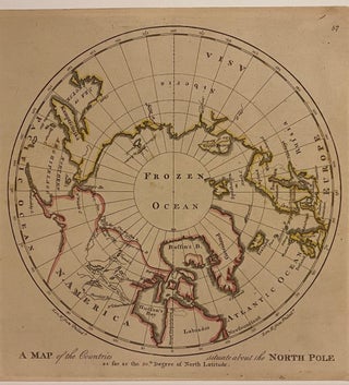
A Map of the Countries situated about the North Pole as far as the 50th Degree of North Latitude
Philadelphia: M. Carey, 1814. Map. Engraving with hand coloring. Image measures 10" x 10", sheet measures 10 3/8" x 17" This 1814 map of the North Pole is centered on the Arctic Circle, labeled as "Frozen Ocean", and oriented along the meridian of Philadelphia, where this map was published. The northern coast of Eurasia is carefully delineated, while the northern edge of North America is less clear. Notations in the northwest indicate the sea extending to the 70th degree of..... More