
The Peyote Religion Among The Navaho.
Illustrated. 454 pages, small 4to, printed wrappers. (N.Y.): Wenner-Gren, 1966. vg. More
Illustrated. 454 pages, small 4to, printed wrappers. (N.Y.): Wenner-Gren, 1966. vg. More
Norman: University of Oklahoma Press, 1973. Illustrated with black and white photographs throughout. 220 pages. 8vo, light blue boards, dust wrapper, worn, spine faded, with a tear along back fold. Norman: University of Oklahoma Press, (1973). A near fine copy, slightly rubbed, in a very good dust wrapper. More
Norman: University of Oklahoma, 2011. Foreword by David L. Boren. Introduction by B. Byron Price. Nearly 200 color plates. xi + 275pp., 4to, blue cloth, d.w. Norman: University of Oklahoma Press, (2011). A fine copy in a near fine dust wrapper. Chapters by various authors. More
New York: Knopf, 2016. Illustrated in color and in black and white. xv, 330 pages. 8vo, light grey boards, d.w. (scuffed). New York: ALfred A. Knopf, 2016. First Edition. Inscribed at title page by the author. Near fine in a very good(+) dust wrapper. More
8vo, cloth. Lincoln: Univ. of Nebraska Press, (1960). More
Washington: National Geographic, 1974. 448 illus., 362 in color. 4to, cloth, d.w. (Washington): National Geographic, (1974). vg. More
Glorieta: Rio Grande Press, 1969. Many illustrations, Frontis. in color and folding. 8vo, green boards, boards soiled. (Glorieta: Rio Grande Press, 1969. More
8vo, cloth-backed boards, d.w. New York, 1980. First edition. A novel based on the Muckaluck Indian War. More
Santa Fe: School of American Research, 1999. Extensively illustrated with color photographs. xiii + 224 pages, 4to, stiff, glossy pictorial wrappers. Santa Fe: School of American Research, (1999). A near fine copy. More
Banning: Malki Museum, 1968. Illustrated. 15 pages, thin 12mo, pictorial wrappers; residue of price sticker on front cover, minor bumping to lower corner. Banning: Malki Museum Press, (1968). A very good(+) copy. Malki Museum Brochure No. 4. More
New York: Macmillan, 1966. Illustrated. 371 pages. 8vo, red cloth, faded at spine ends. New York: Macmillan, (1966). Fifth printing. A very good copy, lacking the dust wrapper. More
London: Thames & Hudson, 1970. With 365 illustrations including 37 color plates. 344 pages, 4to, grey cloth, dust wrapper. London: Thames & Hudson, (1970). A near fine copy in a good dust wrapper (tattered at corners). More
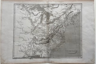
London: Longman, Hurst, Rees & Orne. Map. Original uncolored engraving. Image measures 10 1/4" x 12 1/2". This detailed map of the United States depicts the eastern half of the country, including the Great Lakes, Appalachian Range, and the Mississippi Delta. Published shortly after the Louisiana Purchase, the map features the area west of the Mississippi in lesser detail, noting Native American tribes and villages, rivers, and cities. The Florida peninsula is not depicted. Cities, isles, bodies of water, mountain..... More
Chicago: Childrens Press, 1992. Illustrated. Square 4to, printed wrappers. Chicago: Childrens Place, 1992. Juvenile Edition. Near Fine. More
Flagstaff: KC Publications, 1968. Many color and black-and-white illustrations. 72 pages, 4to, printed wrappers. Flagstaff: KC Publications, 1968. vg. More
Atlanta: Turner, 1993. 449 illustrations, 301 in color. 479 pages. Square 4to, white cloth (spine sunned and front cover illustration and spine lettering lightly faded). Atlanta: Turner Publishing, (1993). A very good(+) copy lacking dust wrapper. More
Oklahoma: University Press, 2004. Illustrated sparingly in black and white. xii, 212 pages. Slim 8vo, blue cloth-backed boards with red lettering, d.w. (scratched). Norman: University of Oklahoma Press, (2004). Near fine in a very good dust wrapper. More
New York: Putnam, 1979. color illustrations 4to, cloth, d.w. New York: Putnam, (1979). vg. More
Terre Haute: AST Press, 1998. Illustrated. 8vo, tan cloth, d.w. creased on front flap. (Terre Haute: AST Press, 1998). Very good. More
New York: Henry Holt, 1996. Illustrated. 540 pages, 8vo, 1/2 black cloth, d.w. New York: Henry Holt, (1996). Very good. More
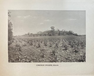
Washington: National Photographic Library, 1907. Rotogravure. Sheet measures 22 1/2" x 28" Large black and white photograph of the Monks Mound in Cahokia, Illinois. Published by the National Photographic Library, founded by Dr. Henry Mason Baum. Embossed seal below title, N.P.L. X in lower left image corner. This print is in very good condition with minor wear at margins. Hard to find. The National Photographic Library was founded in 1906 by Dr. Henry Mason Baum and was among the first..... More
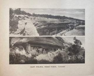
Washington: National Photographic Library, 1907. Rotogravure. Sheet measures 22 1/2" x 28" Beautiful photographic diptych of the Cliff Palace in Mesa Verde, Colorado. Published by the National Photographic Library, founded by Dr. Henry Mason Baum. Embossed seal below title, N.P.L. VII in lower left image corner. This print is in very good condition with minor wear at margins. Hard to find. The National Photographic Library was founded in 1906 by Dr. Henry Mason Baum and was among the first institutions..... More
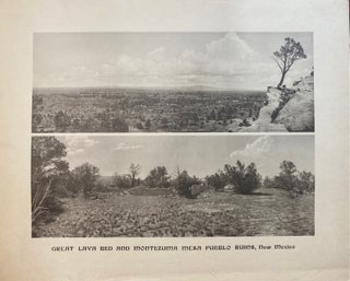
Washington: National Photographic Library, 1907. Rotogravure. Sheet measures 22 1/2" x 28" Large print featuring two photographs of a Great Lava Bed and Montezuma Mesa Pueblo Ruins, in New Mexico, today known as El Malpais National Park. Published by the National Photographic Library, founded by Dr. Henry Mason Baum. Embossed seal below title, N.P.L. VIII in lower left image corner. This print is in very good condition with minor wear at margins. Hard to find. The National Photographic Library was..... More
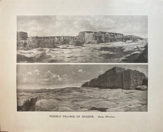
Washington: National Photographic Library, 1907. Rotogravure. Image measures 16 1/4" x 22 1/4" Sweeping panorama views of the Pueblo village of Acoma, New Mexico. Published by the National Photographic Library, founded by Dr. Henry Mason Baum. Embossed seal below title, N.P.L. IX in lower left image corner. This print is in very good condition with minor wear at margins. Hard to find. The National Photographic Library was founded in 1906 by Dr. Henry Mason Baum and was among the first..... More
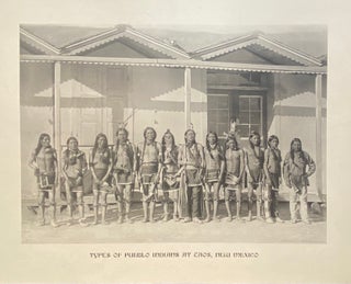
Washington: National Photographic Library, 1907. Rotogravure. Sheet measures 21 7/8" x 26". Large photograph depicting twelve young Native American men in traditional dress, taken in Taos, NM. Published by the National Photographic Library, founded by Dr. Henry Mason Baum. Embossed seal below title, N.P.L. in lower left image corner. This print is in very good condition with minor wear at margins. Hard to find. The National Photographic Library was founded in 1906 by Dr. Henry Mason Baum and was among..... More
I received an out of print book from your store in perfect condition and you took the time and energy to wrap it carefully for protection. I am related to the writer of the book and was so pleased to receive a copy in perfect condition... Because you made the effort to get this book to me in great condition, I wanted to make the effort to thank you!
I saw CNN student news on the other day and impressed how you ladies doing at the bookstore. I am Japanese woman and we value and treasure ancient things. Plus I am a genuine bookworm who prefer printed volumes than electric gadget. So I wanted to say it was a great interview and wonderful to know that there are someone who try to preserve old things rather than sell them and go to Carribean or wherever to swing in hammock. Hope I can visit you someday. Love and respect,