
The Successors of Genghis Khan.
New York: Columbia University Press, 1971. Translated from Persian by John Andrew Boyle. 372 pages, 8vo, blue cloth. New York: Columbia University Press, 1971. A very good(+) copy. More
New York: Columbia University Press, 1971. Translated from Persian by John Andrew Boyle. 372 pages, 8vo, blue cloth. New York: Columbia University Press, 1971. A very good(+) copy. More
London: Luzac, 1958. Translated from the Russian and revised by the author with the assistance of H. A. R. Gibb. Folding map at rear. xxii + 513 pages, tall 8vo, black cloth (spine evenly sunned and pages lightly toned). London: Luzac and Company, 1958. Second edition. A very good(+) copy. More
New York: McGraw-Hill, 1976. Black & white and color illustrations throughout. 264 pages. 8vo, turquoise cloth with gilt lettering at the spine, pictorial d.w. New York: McGraw-Hill, (1976). A near fine copy in a very good(+) dust wrapper. More
New York: Atheneum, 1979. 16 illustrations, 4 maps. 190 pages. Small 8vo, blue cloth, dust wrappe. New York: Atheneum, 1979. A very good(+) copy in a very good dust wrapper. More
New York: Oxford University Press, 1989. Illustrated in color and in black and white. xiii, 176 pages. 4to, blue cloth-backed boards, d.w. (spine sunned). New York: Oxford University Press, 1989. A near fine copy in a near fine dust wrapper. More
New York: Sheed and Ward, 1955. Translated by a nun of Stanbrook Abbey. Fold out map at rear illustrated in black and white. lii, 246 pages. 8vo, light blue cloth, d.w. (spine sunned, edgeworn at spine, corners bumped). New York: Sheed and Ward, 1955. Some neat pencil marginalia, corners bumped, worn at spine. A very good copy in a very good dust wrapper. The Makers of Christendom series. More
New York: Barnes & Noble Books, 1999. A few maps. 8vo, 1/2 maroon cloth, d.w. lightly soiled. New York: Barnes & Noble Books, (1999). Very good. More
Taipei: Ch'eng Wen, 1970. 5 volumes, 8vo, blue cloth; Volume 1 binding is rippled and the top edges of volume 5 are rippled, not affecting the text blocks. Taipei: Ch'eng Wen Publishing, 1970. A very good copy, internally clean. More
New York: Abrams, 1966. Translated from German by E.D. Phillips. 54 illustrations, including 36 in color. 112 pages, large 8vo, cloth, d.w.; small hole to spine of dust wrapper. New York: Harry N. Abrams, (1966). A near fine copy in a very good dust wrapper. More
Cambridge: Harvard University Press, 1958. 2 Volumes. Frontis. 763 pages, 8vo, red cloth, d.w. (soiled) Cambridge: Harvard University Press, 1958. Very good(+) in very good dust wrappers. Translated from the text of Mirza Muhammad Qazvini by John Andrew Boyle. More
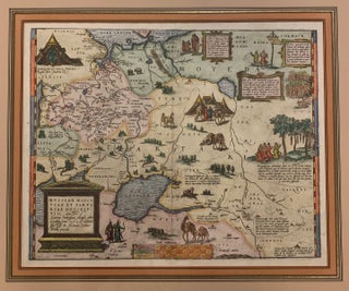
Antwerp: Ortelius, Abraham, 1608. Map. Engraving with beautiful hand coloring. Image measures 14" x 17.5". Gold frame with empire matting 22 1/2 x 25 1/2 inches. Exquisite circa 1608 map of western Russia from the Baltic States, shows the Gulf of Finland, to just beyond the Ob' River in Western Siberia. Includes the Caspian Sea. Richly decorated with folkloric vignettes with descriptions of obscure religious rites to match. Compilation map based on travel accounts. From "Theatrum Orbis Terrarum". Not examined..... More
New York: Praeger, 1969. Illustrated in black and white. 208 pages. 8vo, orange cloth, d.w. (spine sunned, laminate bubbling near spine, price clipped). New York: Praeger, (1969). A near fine copy in a very good(+) dust wrapper. Ancient People and Places series. More
Berkeley: University of California, 1988. 3 maps. vii + 322 pages, 8vo, red cloth. Berkeley: University of California Press, (1988). A very good(+) copy. More
New York: Dorset Press, 1988. 221 pages. 8vo, 1/2 cloth, d.w. (slightly scuffed). New York: Dorset Press, (1988). A near fine copy in a near fine dust wrapper. Translated from the German by Helga and Stuart Drummond. More
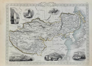
London: Tallis, John, 1851. Map. Steel engraving with early outline color. Image measures 9.75" x 12.75". This map of Tibet, Mongolia and Manchuria offers both geographical and cultural overviews. It extends from modern day Himachal Pradesh in northern India to Sakhalin Island and the Sea of Okhotsk in the North Pacific Ocean, corresponding to the ancient Mongol Empire of Genghis Khan. Karakorum, Genghis Khan's abandoned capital is noted here. The region is abundantly labeled with the names of cities, rivers..... More
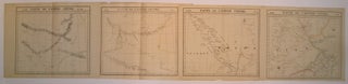
Brussels: Vandermaelen, Phillipe Marie, 1827. Map (set of 4). Large format lithograph with original hand outline color. Each image measures 18.75" x 20 5/8", 18 5/8" x 20 5/8", 18.5" x 20 3/8", Beautifully detailed set of four regional maps of northern China and southern Mongolia. Mountains are delicately treated with hachure marks and major rivers, waterways and cities are also shown. Notable inclusions from the west to the east: Plate 44 shows the very northwestern tip of China (Xinjiang..... More
I flew to NY from CA a couple of weeks ago, and while walking 59th, happened upon Argosy... Amazing! I had very little wiggle room in my time between meetings, but I made sure I came back the next morning, also. I'm so impressed, and reading about the family history of the store impressed me even more. Thank you for having such a marvelous bastion of knowledge there in the city! I was truly impressed.
As an Interior Decorator I am on the constant lookout for source material for my clients. I recently completed a Studio pied a terre in the Georgian period for Mr. David Brown at Lincoln Center. That is, we were almost finished with only the artwork to be designed and purchased. I have a passion for antique architectural prints and I can't believe that I didn't know about Argosy Books. After all Designers don't really like to share their finds with others. I was in a cab, looking out the window as we passed by Argosy Books and noticed a fine selection of framed prints hanging in the window. I had found my oasis! I now head first to Argosy for all my print work and framing. What a treasure and a real lifesaver for design business! Thanks eternal.