
Common Man Mythic Vision: The Paintings of Ben Shahn
New York: Princeton University Press, 1998. Illustrated in black and white and color. 195 pages, 4to, pictorial wrappers. New York: Princeton University Press, (1998). A fine copy. More
New York: Princeton University Press, 1998. Illustrated in black and white and color. 195 pages, 4to, pictorial wrappers. New York: Princeton University Press, (1998). A fine copy. More
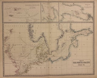
Edinburgh: John Thomson. Map. Engraving with original hand colored outline. Image measures 19 1/2" x 24" Impressive sea chart of the North and Baltic Seas, extending from the eastern coast of England to St. Petersburg. Includes insets of the Harbour of Heligoland, the Port of Revel, and the Harbour of St. Petersburg. Coastlines are carefully rendered, with towns and rivers labeled. Shows marine routes, sandbanks, and depths by soundings. The map is in good condition with chips and tears at..... More
I can't begin to thank you for the personal care and attention you all gave to me on Saturday - when I came to Argosy during your tech breakdown. I love the four marvelous books I purchased for my nephew and the generous wrapping you provided. I shall always remember the experience and look forward to seeing you again soon. With appreciation!
I have received the Paul Johnson book, and everything was excellent. I want to thank you for your efforts and professional courtesy in this transaction, as it was one of the best I've experienced over the past year. I hope that I can do more business in the future with Argosy Books. Thanks again.