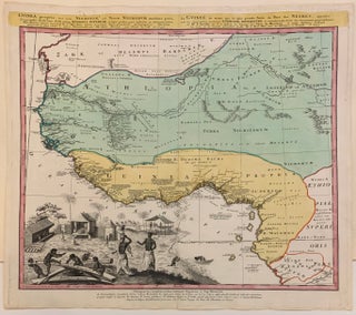
Guinea Propria, Nec Non Nigritiae Vel Terrae Nigorum
Nuremberg: 1743. Map. Engraving with original coloring. In good condition with light foxing. 20 x 21 3/4 inches. Haunting map of West Africa with a focus on Guinea and Senegal. The interior is not thoroughly mapped but port cities are listed and labelled carefully. The Niger River (in Mali) is noted but its course was not yet known to reach the Atlantic by European map makers. Letters indicate which country controls which port: Dutch (H), English (A), Danish (D), and..... More