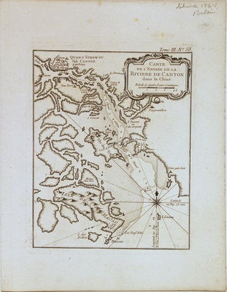
Carte de l'Entree de la Riviere de Canton dans la Chine
Paris: Bellin, Nicolas, 1764. Map. Copper plate engraving. Uncolored. Image measures 8 1/2" x 6 3/4". This impressive 1764 map by Bellin depicts the mouth of the River Canton, including Macao, Shenzhen, Guangzhou (historically called Canton) and the region that would eventually become Hong Kong. The islands are depicted with beautifully rendered coastlines. Depth soundings are included along the channel (Shizi Ocean) and several place names noted. The Island of Macao shows elevations with Macao City identified. Near the top..... More