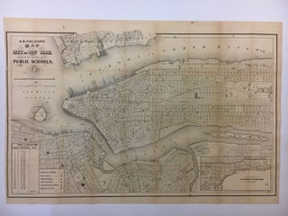
Map of the City of New York Showing the Locality of the Public Schools
New York: Baptist & Taylor, 1864. Map. Lithograph. Page size 17 1/4" x 25 3/4". Image size 16 1/2" x 25 1/4", some foxing and toning to map with 403pp. 12mo, original brown blind-stamped brown cloth, gold insignia on front cover. New York: Hall of the Board of Education. 1864. Very good(+). Fascinating 1864 map of Manhattan showing part of Brooklyn, Hunters Point, Ravenswood and Astoria featuring school locations. Includes an inset of upper Manhattan, ward boundaries, five different school..... More
![Item #243962 [Case of Large School Maps]. RAND MCNALLY, CO](https://argosybooks.cdn.bibliopolis.com/pictures/243962.jpg?width=320&height=427&fit=bounds&auto=webp&v=1375459883)
