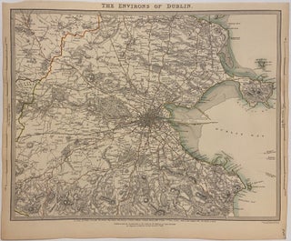
Plan of the City of Dublin Showing Increase in Buildings During 35 Years (1870-1905)
London: Weller & Graham, 1906. Map. Lithograph. London: Weller & Graham, 1906. Image measures 16 1/8" x 18 1/2" Detailed map from the early 20th century highlighting the urban development of Dublin between 1870 and 1905. The map shows tramways constructed between 1872 and 1904, delineated in blue. Buildings erected between 1870 and 1905 are shown in red. Published in Appendix J of the "Report of the Royal Commission on London Traffic". Original fold lines as issued. In excellent condition..... More