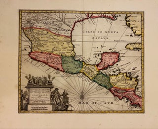
Nouvelle Espagne, Nouvelle Galice, et Guatimala
Leiden: Van der Aa, Pierre, 1729. Map. Engraving with full hand coloring. Image measures 11 1/2" x 14". Leiden: 1729. Finely engraved map of Mexico and Central America. Beautifully detailed, the map labels regions, towns, rivers, lakes, and coastal features. Mountains are depicted pictorially. Includes parts of Florida and Cuba. Features an elaborate title cartouche in the lower left corner. In excellent condition with full margins and lavish original color wash. Pieter van der Aa (1659-1733) was a Dutch publisher..... More
