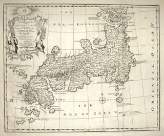
A New and Accurate Map of the Empire of Japan
Map. Engraving. Image measures 14 x 17". This map of the Empire of Japan owes its detail to the writings of Jesuit missionaries and Portuguese and Dutch explorers. The interior of the archipelago is described in great detail, with the names of cities, towns, rivers, and lakes dispersed among pictorial mountains. Furthermore, the map contains ample information about many the smaller islands of the archipelago, which are often accompanied by explanatory notes about discovery and colonialism. Some significant features of..... More

![Item #273380 [Southeast Asia]; Rare 1725 Map of East Indies and South East Asia. RENNEVILLE](https://argosybooks.cdn.bibliopolis.com/pictures/273380.jpg?width=320&height=427&fit=bounds&auto=webp&v=1487284208)