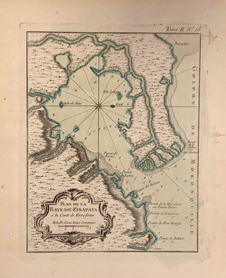
Plan de la Baye de Zisapata
Paris: Jacques Nicolas Bellin, 1764. Map. Uncolored engraving. Image measures 8 3/4" x 6 1/2" Lovely nautical chart of the Bay of Cispata, Colombia. Indicates depths by soundings. Points, rivers, and islands are labeled. Jacques Nicolas Bellin (1703-1772), was the official hydrographer to the French king and the first person to hold the title of "Ingenieur de la Marine of the Depot des cartes et plans de la Marine" (chief engineer of the French Hydrographical Office)... More