
L'univers Magique de Lyonel Laurenceau.
Quebec: 1986. Many color illustrations. 4to, black boards. (Quebec: Laurenceau, 1986). Near Fine. Scarce. More
Quebec: 1986. Many color illustrations. 4to, black boards. (Quebec: Laurenceau, 1986). Near Fine. Scarce. More
Seattle: 1902. Many photo illustrations by E. A. Hegg. 126pp. Oblong 4to, original tan cloth, spine rebacked in new black cloth, covers soiled, front flyleaf and some margins of plates lightly soiled, upper right corners of plates creased, inner hinge strengthened. Seattle, (1902). First Edition. Entire text is published photo illustrations of Alaska and the Yukon Territory. There is one folding panorama of Dawson, Yukon Territory. The images are bright. More
Boston: Houghton Mifflin, 1965. Illus. 423pp. 8vo, brown cloth, d.w. chipped and dampstained. Boston: Houghton Mifflin, (1965). More
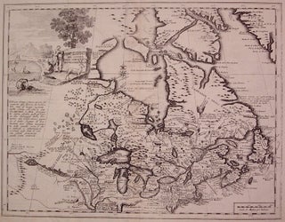
Venice: Giovanni Battista Albrizzi, 1740. Map. Uncolored engraving. Image measures 13" x 16.75". Exquisite map of Canada showing the Great Lakes in detail with beautiful country vignette cartouche. Detailed explorers notes engraved throughout including Baron di Lahontan's accounts of the West. Some discoloration along centerfold and edges but in pleasing black and white state. Giovanni Battista Albrizzi (1698-1777) was a prominent Venetian publisher of books and maps. He inherited his business from his father and was part of a family..... More
Toronto: Macmillan, 1976. 8vo, pr. wrs., wrappers lightly soiled. (Toronto): Macmillan, (1976). More
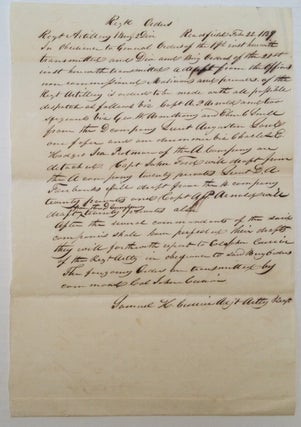
Readfield: 1839. 1 page, 11 x 7.75 inches, Readfield, February 22, 1839. Outstanding and historically important autographed document regarding a dispute between Maine and New Brunswick, signed "Samuel K. Currier," Adjutant, Regiment Artillery 1st Brigade - 2nd Division. In part: "In obedience to General Orders of the 19th, instituted and herewith transmitted...of the 21st...a draft of the Regiment Artillery is ordered to be made with all possible dispatch as follows...vis...Capt. A. P. Arnolds and two sergeants; George W. Armstrong from..... More
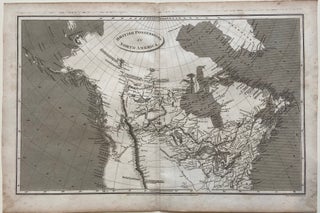
London: Longman, Hurst, Rees & Orne, 1809. Map. Original uncolored engraving. Sheet measures 11 1/2" x 17 1/8". This detailed map shows British territories in North America. Although published in 1809, it was made after an 1804 map by Arrowsmith that captured an important moment in North American history at the start of westward expansion. The map includes the Arctic Circle, from Greenland to the Bering Strait, extending south to 35 degrees, the convergence of the Missouri and Mississippi Rivers..... More
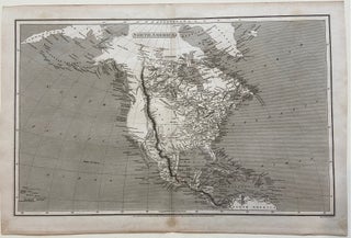
London: Longman, Hurst, Rees & Orne, 1809. Map. Original uncolored engraving. Sheet measures 11 1/2" x 17 1/8". This detailed map shows North America. The map includes the Arctic Circle, from Iceland to eastern Asia, extending southward to the Caribbean coast of South America. The Rocky Mountain Range is depicted prominently, drawn as one cordillera extending from Canada and connecting to the Sierra Madre mountains through Mexico and the Cordillera Central in Central America. The combined ranges are labeled "the..... More
394 text illus. sq. 4to, cloth, d.w. Univ. of Toronto Pr., (1964). More
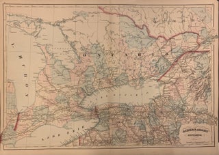
New York: Asher & Adams, 1873. Map. Lithograph original hand coloring. Image measures 17 1/4" x 24". This large scale 1873 map depicts Ontario, Canada and it's RR systems. Districts are hand colored and railway lines are labeled. City and town names occur as well as stops along the routes. Rivers, bays, capes, islands and other topographic features are also noted throughout. Small chips to corner, does not affect image. Asher & Adams were publishers based in Washington and New..... More
Baltimore: The Order of Colonial Lords, 1927. Illustrated. 22 pages, thin 8vo, printed wrappers. Baltimore: The Order of Colonial Lords in America April, 1927. A fine copy. More
London: John Murray, 1836. Illustrated with a large folding map, 16 engraved plates, some text illustrations. x, [2], 663pp., thick 8vo, 3/4 brown calf; (rubbed, corners bumped, light foxing on some pages and plate margins, full page inscription by previous owner on flyleaf). London: John Murray, 1836. Very good. A fine source for both the early exploration of the far North as well as ethnology, includes details about Back's commerce with the Cree, Chippewa, and Coppermine Indians, and information relating..... More
13 maps and 12 plans, in color, some folding. 18mo, cloth; (text dampstained, maps and plans not stained; cloth lightly soiled, otherwise very good). Leipzig: Baedeker, 1907. More
New York: Dodd, Mead & Co., 1885. 20 maps and plates, some of the maps are folding. 2 volumes. 8vo, original green cloth, ex-lib, cloth lightly soiled on both volumes, corners lightly bumped on both volumes, foxing to Frontis. and title-page margin in both volumes, inner hinges strengthened in volume II. New York: Dodd, Mead, (1885). First Edition. "A pioneer work of highest grade...The author analyzes the episode of the Revocation, the flight from various parts of France, the refuge..... More
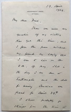
Ottawa, Canada: 1939. 2 pages (front and back), 8 x 5 inches, Government House, Ottawa, April 19, 1939. Written to powerful New York attorney Frederic R. Coudert during a lecture tour of Canada, in part: "...Nothing is settled yet and I will try and send you a line from Toronto if I have made any final arrangements while I am here. I only came over to give off these lectures which I hoped might be of use in Canada at..... More
New Brunswick: Rutgers University Press, 1962. Illus. 8vo, two-toned cloth, d.w. lightly soiled, corners bumped on covers. New Brunswick: Rutgers University Press, (1962). Some songs with printed English translation. More
Toronto: University of Toronto Press, 1996. Illus. Small 4to, pr. wrs. Toronto: University of Toronto Press, (1996). Fine Presentation copy from one of the editors, John O'Brian, to Nan (Rosenthal). From the library of Nan Rosenthal, who was a curator of modern art at the Metropolitan Musuem of Art and National Gallery of Art, with her ownership signature. More
Montreal: Dodd-Simpson, 1915. Illustrated with hundreds of b/w photographic reproductions. 3 volumes. Short slim 4tos, original beige cloth with decorative pictorial covers; one volume stained on cover and all are well-worn at corners with spines darkened and a bit rippled. Montreal: Dodd-Simpson, 1915. Overall a very good(-) set. A Complete History of the opening period of the Great European Conflagration from the Servian incident to the turning back of the German invaders from the Gates of paris. More
Winfield: Wedgestone Press, 1983. Ed. by Thomas Brott and Phillip Kelley. Illus. 128pp. 8vo, pr. wrs. (Winfield): Wedgestone Press, (1983). Fine. More
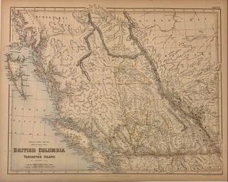
Edinburgh: Fullarton, Archibald, 1857. Map. Color engraving. Image measures 16" x 20 3/4". 1857. This is a wonderful map of the West Coast of Canada. Abundantly labeled with the names of cities, ports, rivers, mountains. Describes as far North as Hudson Bay Territory and Sikani Indian territory. Show the newly discovered gold fields in the upper Fraser River region called 'Cariboo diggings'. From Fullarton's "Royal Illustrated Atlas", considered the last highly decorative atlas published in England. Beautifully engraved and colored..... More
New York: Fleming H. Revell, 1925. Illus. 8vo, half tan cloth, spine lightly soiled, edges of corners lightly worn. New York: Fleming H. Revell, (1925). Presentation copy. Narrative of the author's travels. Pages 1-152 are on New Mexico. Pages 153-196 are on Newfoundland. Pages 226-282 are on Guyana. More
Rosedale, 1993. Foreword by Jack Nicklaus, Photography by Nancy Westway. Extensively illustrated. 224 pages, 4to, blue cloth, d.w. Printed by Friesen for Rosedale Golf Club, (1993). A fine copy in a fine dust wrapper. More
Greenwich: New York Graphic Society, 1973. Color frontispiece, 118 color and 103 black and white illustrations. 224pp., thick 4to, brown cloth, d.w.; (slightly chipped). Greenwich, CT: New York Graphic Society, (1973). Very Good (+). More
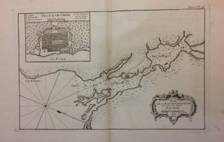
Paris: Jacques Nicolas Bellin, 1763. Map. Uncolored engraving. Image measures 8.25" x 13.75", sheet measures 12" x 19". Some light fading and staining at edges. In very good condition. A fantastic early map of Halifax, published in Bellin's 'Petit Atlas Maritime'. Inset shows the town plan of Halifax.Jacques Nicolas Bellin (1703-1772), was the official hydrographer to the French king and the first person to hold the title of "Ingénieur de la Marine of the Depot des cartes et plans de..... More
New York: Viking, 1967. Essays, poems and journals edited by Milton Wilson. 56 pages in full color, 144 pages in black and white photogravure, 10 maps and line drawings. 324 pages. Folio, gilt-lettered black cloth. New York: Viking Press, (1967). First edition. Small gift inscription on title page and cloth is a bit dusty, else a very good(+) copy. More
The book arrived yesterday, was beautifully packaged for careful shipping and is exactly as described... I am thrilled to have this book to add to my library. Looking forward to additional purchases. Many thanks.
I have just received the copy of I, Robot Screenplay published by Easton Press and signed by Harlan Ellison which I ordered just after the middle of June 2003. The book arrived in the condition in which it was sent and I am glad that I ordered it from you. Will certainly order from Argosy Book Store again in future!