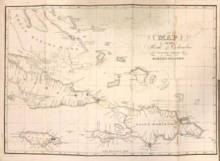
Map of the Route of Columbus, on arriving among the Bahama Islands
Wicks Nautical Store, 1841. Map. Measures 15.5 x 20.75". Miniature sailing chart showing the route of Columbus from Oct. 11, 1492 up to approx. the 1st. of Dec. 1492. Also shown are the Great Bahama Bank, the Old Bahama Channel, part of Cuba, Jamaica, and Saint Domingo. Plan by D.G. Johnson. Lettered by D.R. Harrison. Dampstaining but otherwise in good condition. More