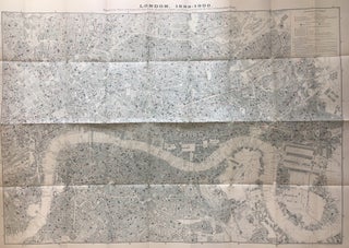
London, 1899-1900; Map showing Places of Religious Worship, Public Elementary Schools, and Houses Licensed for the Sale of Intoxicating Drinks
London: Stanford's Geographical Establishment, 1902. Map. Color lithograph. Image size 26" x 36 3/4", page size 27" x 40 1/4". Iconic map which was included in the final series of three of Charles Booth's "Life and Labour of the People of London." The last series was a conclusion of the previous two. This particular map was intended to highlight the hierarchy of social influences in London, showing an overwhelming number of houses that sell alcohol as compared to schools and..... More