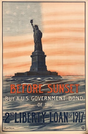
Before Sunset Buy a U.S. Government Bond of the 2nd Liberty Loan of 1917
New York: Sackett & Wilhelms Corporation, 1917. Original Poster. Lithograph. Measures 30 x 20". This poster features the Statue of Liberty superimposed on a faintly and artfully rendered American flag. Vibrant red, white, and blue lettering is superimposed over the sea beneath the statue, urging the population to buy bonds. This poster is in excellent condition, and is a wonderful document for anybody interested in American memorabilia. One of the few female artists designing posters during the war, Eugenie De..... More