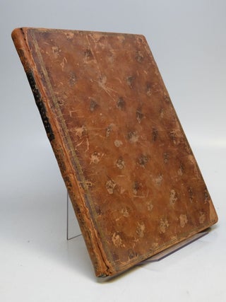
Birds Of The Caribbean.
New York: Viking, 1961. 98 color plates. 4to, green cloth, spine faded from sun exposure, cloth dampstained, bottom edge of back cover lightly worn, New York: Viking Press, (1961). More
16 plates including engraved t.p., with tissue guards. 4to, contemporary mottled calf, leather label, a.e.g.; (covers lightly worn, front cover lightly bowed, internally very good except for a some foxing to the margins of the plates). Paris: Ponce and Godefroy, n.d., [1784]. "First French book with a title-page mentioning the United States." Howes C-576. This copy is "another issue" according to Howes, USIANA, with no separate title-page. It was published in the same year as the issue with a separate..... More
New Haven: Yale University Press, 1923. in the years 1774 to 1776. Illus. 8vo, 3/4 gray cloth, boards worn on edges, pages slightly wavy throughout. New Haven: Yale University Press, 1923. Author stayed in St. Kitts, Antigua, Wilimington, North Carolina, and Lisbon. More
London: Longman, Hurst, Rees & Orne. Map. Original uncolored engraving. Image measures 10" x 16". This detailed map of the West Indies covers the southern portion of the US extending to the Northern coast of South America. Includes Mexico, Central America, the Gulf of Mexico, the Florida Peninsula, and the Caribbean Sea. Cities, isles, bodies of water, mountain ranges and coastal features are labeled. The map is in good condition. Minimal wear along original folds. Minor stains to lower margin..... More
Chapel Hill: University of North Carolina Press, 2007. Illus. 427pp. 8vo, two-toned cloth, d.w. Chapel Hill: University of North Carolina Press, (2007). Fine. More
New York: Duell Sloan and Pearce, 1966. illus. 8vo, blue cloth, front cover very lightly dampstained. New York: Duell, Sloan and Pearce, (1966). More
Kingston: Sangster's Book Store, 1966. Notes and Introduction by Rex Nettleford. Illus. 8vo, red cloth, d.w. with a small amount of light edgewear and inner flaps creased, bookplate of previous owner. (Kingston): Sangster's Book Store, (1966). First Edition. Jamaica Dialect Poems. More
illus. 8vo, cloth, d.w. Garden City, 1974. More
Bermuda: Trade Development Board, 1936. 51 illustrations, 8 full page watercolors by Adolph Treidlerin, the black & white plates are photographic illustrations by David Knudsen, Walter Rutherford, Thurman Rotan and F.S. Lincoln. 94 pages, tall slim folio, blue and silver cloth. n.p.: (Bermuda Trade Development Board), 1936. Designed and produced by James Albert Wales and Lorraine Follett. Printed in the U.S.A. by Edward Stern & Company, Inc. Philadelphia. Limited First Edition. Near Fine. 1029 of 2000 numbered copies... More
Albany: State University of New York Press, 2006. 8vo, black boards. Albany: State University of New York Press, (2006). Very good. More
Rio Piedras: Universidad de Puerto Rico, 1979. 4 volumes, bound in five. 1500; 702; 601; 621 pages. Tall 8vos, red leatherette with highly decorative spines, edgeworn & spotted d.w. Rio Piedras: Universidad de Puerto Rico, (1979). Light spotting on fore-edge and a few bent corners, else a near fine set in good dust wrappers. More
Paris: Horizions de France, 1958. 100 photo Illus., two maps. 4to, pr. wrs. Paris: Horizons de France, (1958). Very good. More
London: Laurie & Whittle, 1794. Map. Copper plate engraving. Original hand coloring outlines and modern hand coloring on cartouche and scale. Page measures 41 1/2" x 47". Stunning wall map of North America, Central America and the West Indies, published in 1794. Features an ornate title cartouche with a Native American male, female and child lounging amidst furs, cloth, a parrot and a monkey. The map details topographical elements, locations of Native American tribes, extensive place names, forts, waterways and..... More
Boston: T.G. Bradford, 1846. Map. Engraving with original hand coloring. Image measures 11.25 x 14". This desirable 1846 map of the West Indies was issued by T. G. Bradford. It extends from southern Florida to the Gulf of Panama and the Spanish Main and includes the Bahamas, the Leeward and Windward Islands. An inset near top center details the Bermudas. Towns, rivers, mountains and various other important topographical details are noted. Copyrighted to 1838, the map is corrected to 1846..... More
London: Reader's Union, 1963. 8vo, cloth, d.w. London: Reader's Union, 1963. Account of the author's work in the London Dept. of Child Welfare. More
London: Collins and Harvill Press, 1980. Edited and completed by Nicholas Guppy. Illus. 8vo, green cloth, d.w. London: Collins and Harvill Press, (1980). First Edition Memoirs of growing up in Trinidad in the latter part of the 19th century. Nicholas Guppy was the author's nephew. More
Berkeley: University of California Press, 2002. A few maps. 8vo, pr. wrs. Berkeley: University of California Press, (2002). Fine. More
New York: Greenberg, 1947. 10 maps. 8vo, maroon cloth, d.w. and cloth lightly soiled, d.w. chipped. New York: Greenberg, (1947). More
London: Verso, 1988. 197pp. 8vo, black cloth, d.w. with a few small tears, inner flaps of d.w. creased, back cover of cloth lightly soiled. London: Verso, (1988). First Edition. More
Durham: Duke University Press, 2001. 422pp. 8vo, blue cloth. Durham: Duke University Press, 2001. Near Fine. More
3 hand colored folding copperplate maps. 228pp. 8vo, 1/2 morocco: (rubbed, front cover detached). London: R. Baldwin, 1763. First edition. "This work is a classic in the field of colonial and Caribbean literature, embodying as it does one of the clearest statements of eighteenth century philosophy regarding the relations which should exist between a metropole and its outlying possessions." Ragatz, p. 284. Maps depict the Lesser Antilles and Grenada. Sabin 10232. Kress 6081. More
Philadelphia: Carey & Lea, 1822. Map. Engraving with original hand coloring. Image measures 15"x 14.5", image plus text measures 16.5" x 20.5". Beautiful map of Puerto Rico and the Virgin Islands on a large scale. An explanation of colonial activity is provided as well as the publisher's signature text surround pertaining to history, climate and culture. The map was printed in Carey & Lea's "Complete Historical, Chronological, and Geographical American Atlas". Very good condition with no chips or tears or..... More
Philadelphia: Carey & Lea, 1822. Map. Engraving with original hand coloring. Image measures 11.5" x 9.25", image plus text measures 16 5/8" x 20.5". Nice map of the Leeward Islands (also known as the Lesser Antilles), including information pertaining to history, climate and culture of Mariegalante, Deseada, Dominica, Aguilla, St. Martin, St. Bartholomew, Saba, Barbuda, St. Eustatia, St. Christopher's (St. Kitt's), Nevis, Antigua, Monserrat and Guadeloupe. From "A Complete Historical, Chronological, and Geographical American Atlas..." of 1822. Minor aging along..... More
Philadelphia: Carey & Lea, 1822. Map. Engraving with original hand coloring. Image measures 12.25" x 15 7/8", image plus text measures 16.75 " x 21.75". Nicely detailed map of the West Indies chain, including information pertaining to history, climate and culture. From "A Complete Historical, Chronological, and Geographical American Atlas..." of 1822. Minor aging along edges, a few small tears to bottom edge. More
Philadelphia: Carey & Lea, 1822. Map. Engraving with original hand coloring. Image measures 11 5/8" x 10", image plus text measures 16 5/8" x 20.75". Nice map of the Windward Islands, including information pertaining to history, climate and culture of Martinique, St. Lucia, St. Vincent, Barbados, Grenada, Trinidad and Tobago. From "A Complete Historical, Chronological, and Geographical American Atlas..." of 1822. Minor aging along edges, small chip to lower right corner. More
I have received the book here in Egypt in excellent shape. I wish to express my extreme satisfaction for the excellent service you offered me. Thanks again!
Your web site is among the very best offered in the antiquarian book trade, but more than that, it represents the store and its web business in a professional manner.