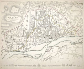
Warsaw
London: Baldwin & Cradock, 1844. Map. Engraving with hand outline coloring. Image measures 11.5 x 14.5". This detailed plan of Warsaw provides insight into the city's history. The map itself depicts the city around 1831, rendering in exacting detail the shapes of buildings and curves of streets that make up its structure. Within this rendering, a dashed line highlighted in yellow points out the boundary of the city in 1762. This inclusion reveals the extent of growth which the city..... More